A method for measuring the height of quadrotor UAV under strong wind conditions

A four-rotor UAV and height measurement technology, applied in the field of UAV navigation, can solve the problems of severe vibration, low applicability of laser and radar, and large noise in satellite navigation measurement height, so as to enhance the robustness of the system Effect

Active Publication Date: 2019-12-31
中国航天电子技术研究院
View PDF4 Cites 0 Cited by
  • Summary
  • Abstract
  • Description
  • Claims
  • Application Information

AI Technical Summary

Problems solved by technology

[0002] At present, UAV altitude measurement methods mainly include air pressure altitude, satellite navigation, ultrasonic, laser, radar, etc. Due to the limited load capacity of the quadrotor, the applicability of laser and radar is not high, and ultrasonic altimetry cannot meet most occasions due to the short measurement distance. Require
[0003] Under strong wind conditions, it is more difficult to measure the height of quadrotor UAVs. The strong airflow will greatly disturb the measurement of air pressure altitude, and the working environment of the airframe is harsh, the vibration is severe, the accuracy of the inertial sensor is degraded, and there may even be a failure state. Satellite navigation measurement altitude exists Noisy and lagging

Method used


Image

  • A method for measuring the height of quadrotor UAV under strong wind conditions
  • A method for measuring the height of quadrotor UAV under strong wind conditions
  • A method for measuring the height of quadrotor UAV under strong wind conditions

Examples


Embodiment Construction

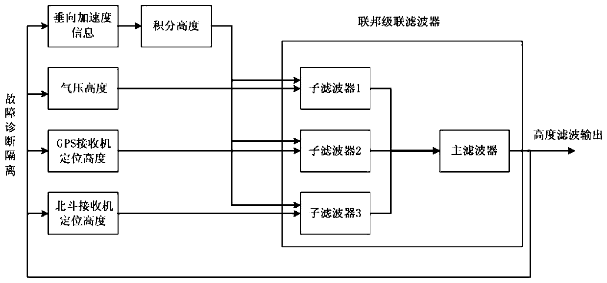
[0023] In order to make the object, technical solution and advantages of the present invention clearer, the present invention will be further described in detail below in conjunction with the accompanying drawings and embodiments. It should be understood that the specific embodiments described here are only used to explain the present invention, not to limit the present invention. On the contrary, the invention covers any alternatives, modifications, equivalent methods and schemes within the spirit and scope of the invention as defined by the claims. Further, in order to make the public have a better understanding of the present invention, some specific details are described in detail in the detailed description of the present invention below. The present invention can be fully understood by those skilled in the art without the description of these detailed parts.

[0024] The present invention will be further described below in conjunction with the accompanying drawings and ...


PUM


Abstract

The invention provides a height measurement method of a four-rotor-wing unmanned aerial vehicle under a strong wind condition. The method comprises the following steps: constructing a union cascade filter through first height information provided by an accelerometer, second height information provided by a barometric altimeter, third height information provided by a GPS (Global Positioning System) receiver and fourth height information provided by a Beidou receiver; and finishing height filtering output so as to realize height measurement. According to the height measurement method provided by the invention, the height can be directly measured in an invalid state under the conditions that satellite navigation height measurement causes relatively high noises and hysteresis is serious; and feedback adjustment can be used for enhancing the system robustness and the flight safety is not influenced.

Description

technical field [0001] The invention belongs to the technical field of unmanned aerial vehicle navigation, and in particular relates to a method for measuring the height of a four-rotor unmanned aerial vehicle under strong wind conditions. Background technique [0002] At present, UAV altitude measurement methods mainly include air pressure altitude, satellite navigation, ultrasonic, laser, radar, etc. Due to the limited load capacity of the quadrotor, the applicability of laser and radar is not high, and ultrasonic altimetry cannot meet most occasions due to the short measurement distance. Require. [0003] Under strong wind conditions, it is more difficult to measure the height of quadrotor UAVs. The strong airflow will greatly disturb the measurement of air pressure altitude, and the working environment of the airframe is harsh, the vibration is severe, the accuracy of the inertial sensor is degraded, and there may even be a failure state. Satellite navigation measurement...

Claims


Application Information

Patent Timeline
Patent Type & Authority Patents(China)
IPC IPC(8): G01C5/00G01C5/06G01S19/14
CPCG01C5/005G01C5/06G01S19/14
Inventor 倪书豪姜梁王富贵于翔海龚晶郭庆徐发洋
Owner 中国航天电子技术研究院
Why Eureka
Try Eureka