
A multi-lens and multi-detector aerial camera single-center projection conversion method

A technology of central projection and conversion method, applied in the field of aero-optical remote sensing, which can solve the problem of precision control that is rarely answered, fails to clarify the process link of multi-center projection to single-center projection, and fails to define the splicing model to the equivalent virtual image splicing Accuracy and other issues

Active Publication Date: 2018-10-19
BEIJING RES INST OF SPATIAL MECHANICAL & ELECTRICAL TECH
View PDF6 Cites 0 Cited by
  • Summary
  • Abstract
  • Description
  • Claims
  • Application Information

AI Technical Summary

Problems solved by technology

There are at least two deficiencies in the area array stitching imaging technology of existing aerial surveying and mapping cameras: on the one hand, the above-mentioned core issues are rarely disclosed, and the various process links of multi-center projection to single-center projection are not clarified; on the other hand, few answers are given. The accuracy control problem of the transformation from the central projection to the equivalent monocentric projection, and the influence of the stitching model on the stitching accuracy of the equivalent virtual image cannot be clarified

Method used


Image

  • A multi-lens and multi-detector aerial camera single-center projection conversion method
  • A multi-lens and multi-detector aerial camera single-center projection conversion method
  • A multi-lens and multi-detector aerial camera single-center projection conversion method

Examples


Embodiment Construction

[0046] Specific embodiments of the present invention are further described in detail below.

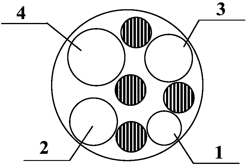
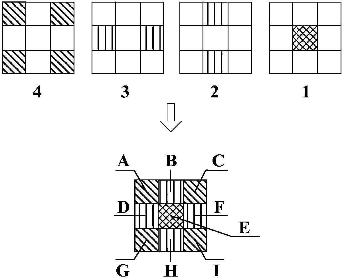
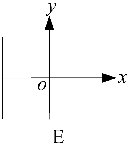
[0047] 1) for figure 1 The lens diagram of the multi-lens and multi-detector aerial camera shown, 1, 2, 3 and 4 represent four panchromatic lenses, and the corresponding four cameras (hereinafter referred to as panchromatic lens 1~4 cameras) are polycentric projections Imaging, the number and distribution of detectors contained in each, see figure 2 . figure 2 A~I in the table represent the number of detectors: E is the center detector, corresponding to figure 1 The panchromatic lens 1; B, H corresponding figure 1 The panchromatic lens 2; D, F corresponding figure 1 Panchromatic lens 3; A, C, G, I corresponding figure 1 Panchromatic lens4. choose figure 2 The image of the center detector E in is used as the reference image, and its geometric center point is taken as the origin o of the image plane coordinate system to construct a right-hand plane Cartesian coordinate system,...


PUM


Abstract

The invention provides a single-center projection transformation method of a multi-lens and multi-detector aerial camera. The single-center projection transformation method comprises the following steps: 1) establishing a virtual image space coordinate system with uniform standards; 2) establishing a mathematical model for reflecting a related position relation between multi-lens cameras and a related position relation between a plurality of detectors; 3) solving combined position elements and distortion parameters of a plurality of lenses and the plurality of detectors through static geometric calibration; 4) establishing a mathematical mode for related position changes of images of the plurality of detectors in a dynamic flight process; 5) obtaining identical points of overlapped regions of the images of the plurality of detectors through rapid matching of short-baseline images; 6) establishing a self-calibration error equation according to an identical points coordinate error minimum principle; 7) carrying out a point-by-point method and finishing iterative solution according to a least squares adjustment principle, so as to obtain accurate related position element in the dynamic flight process. The method provided by the invention is universally applicable to generation of equivalent single-center projection virtual images of a multi-lens and multi-detector area array splicing type aerial mapping camera.

Description

technical field [0001] The invention belongs to the technical field of aerial optical remote sensing, and relates to a method for converting a multi-lens and multi-detector spliced ​​aerial surveying and mapping camera from multi-center projection to equivalent single-center projection. Background technique [0002] Area array cameras with large format, large field of view, and high pixel resolution are the inevitable development direction of imaging sensors in the field of photogrammetry. However, limited by the technical bottleneck and high cost of a single large-format CCD\CMOS device, it has become a mainstream method to construct an equivalent large-format sensor array by combining multiple lenses and multiple detectors. [0003] The core problem of the multi-lens and multi-detector splicing construction of the area array aerial surveying camera is how to normalize the multi-center projection during imaging into an equivalent single-center projection conformation. Ther...

Claims


Application Information

Patent Timeline
Patent Type & Authority Patents(China)
IPC IPC(8): G01C11/04G06T3/20
CPCG01C11/04G06T3/20
Inventor 姚娜林招荣尚志鸣钟灿刘秀王丽王哲李冰李林鹏
Owner BEIJING RES INST OF SPATIAL MECHANICAL & ELECTRICAL TECH
Learn More