
A Method of Dynamic Customization of Spatial Data Thematic Map Based on Web

A technology of spatial data and thematic maps, which is applied in the fields of network data retrieval, other database retrieval, electronic digital data processing, etc. It can solve the problem of insufficient release methods of multi-source spatial data, lack of flexibility in map release, long processing time of online browsing data, etc. question

Active Publication Date: 2020-10-23
INST OF REMOTE SENSING & DIGITAL EARTH CHINESE ACADEMY OF SCI
View PDF3 Cites 0 Cited by
  • Summary
  • Abstract
  • Description
  • Claims
  • Application Information

AI Technical Summary

Problems solved by technology

[0007] Aiming at the above-mentioned technical problems in related technologies, the present invention proposes a method for dynamically customizing spatial data thematic maps based on Web, which is used to solve the problem of insufficient intelligence and openness of multi-source spatial data publishing, long processing time of online browsing data and lack of map publishing. question of flexibility

Method used


Image

  • A Method of Dynamic Customization of Spatial Data Thematic Map Based on Web
  • A Method of Dynamic Customization of Spatial Data Thematic Map Based on Web
  • A Method of Dynamic Customization of Spatial Data Thematic Map Based on Web

Examples


Embodiment Construction

[0054] The following clearly and completely describes the technical solutions in the embodiments of the present invention. Obviously, the described embodiments are only some of the embodiments of the present invention, but not all of them. All other embodiments obtained by persons of ordinary skill in the art based on the embodiments of the present invention belong to the protection scope of the present invention.

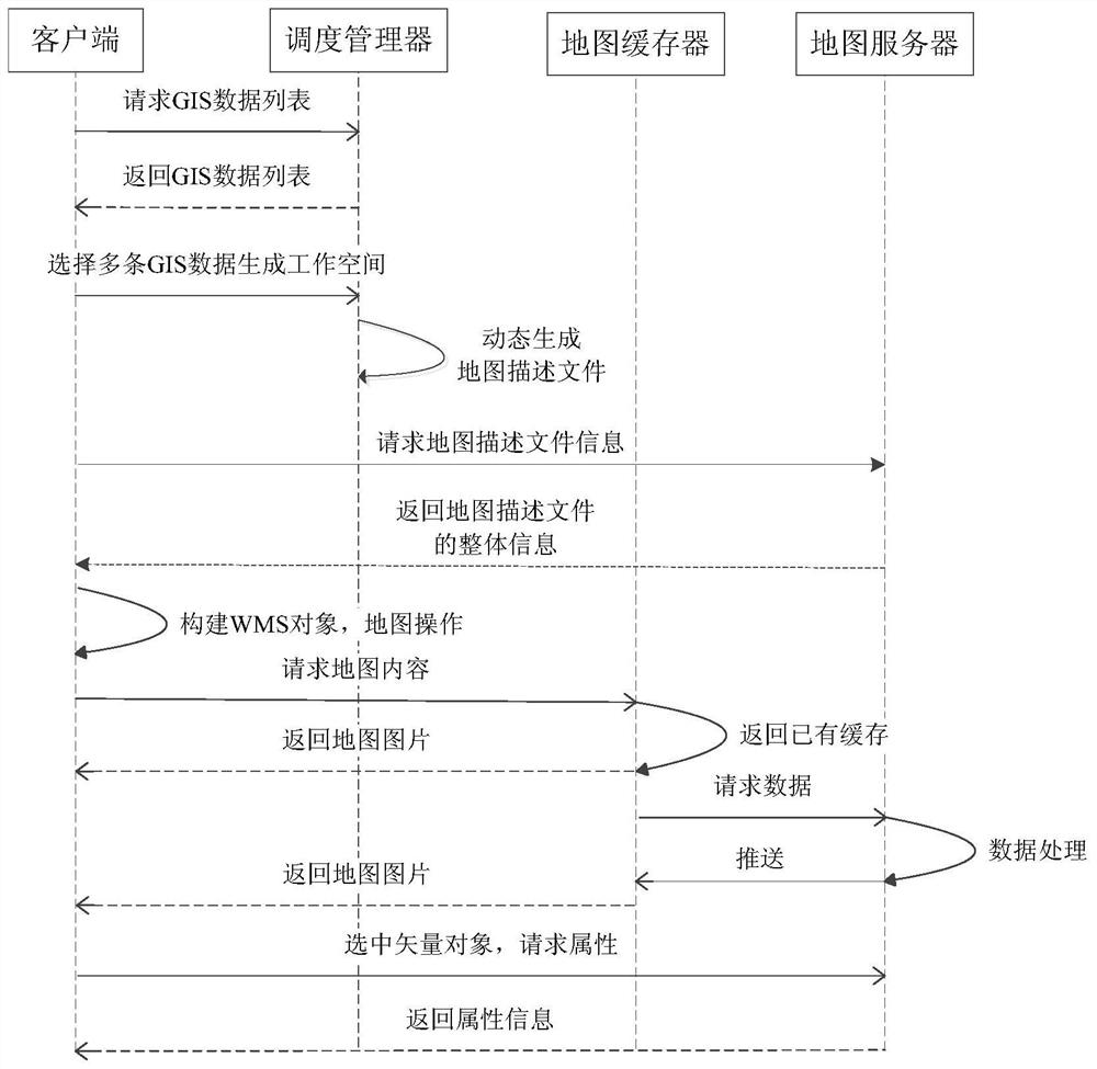
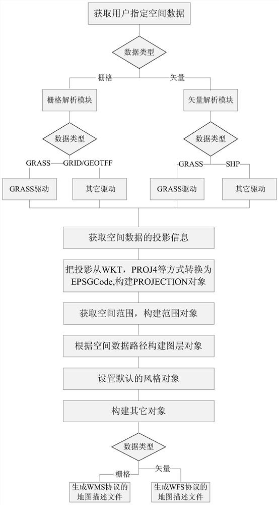
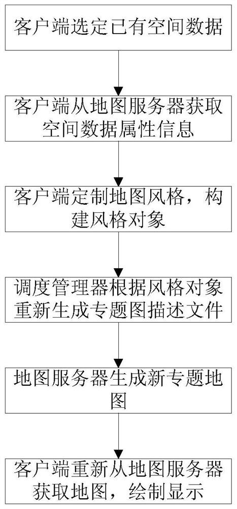
[0055] like figure 1 As shown, a web-based method for dynamically customizing spatial data thematic maps includes the following steps:

[0056] S1. Dynamic generation of map description files: parse objects required by map description files from spatial data, and generate map description files according to user-specified data;

[0057]S2. On-demand customization of thematic maps: modify the map description file online through server customization, and the map server publishes a new map;

[0058] S3. Dynamic and static caching: use caching and tile pre-generation...


PUM


Abstract

The invention discloses a web-based dynamic customizing method for spatial data thematic maps. The web-based dynamic customizing method includes the steps of S1, dynamic generation of map description files, S2, thematic map customization as required, S3, dynamic and static caching, and S4, dynamic issuance of spatial data. The web-based dynamic customizing method has the advantages that dynamic issuance strategies for the spatial data are provided, and technologies such as generating maps based on OGC (open geospatial consortium) protocols according to needs as well as dynamic and static caching are realized; the problems that multisource spatial data issuance modes are not intelligent, flexible and open enough, online spatial data browsing time is long and user experience is poor are further solved; users without professional backgrounds can define map styles by themselves and browse any spatial data specified by themselves, dynamic and efficient issuance, as required, of network thematic maps is realized, and browsing efficiency of the spatial data is improved at the visualization level.

Description

technical field [0001] The invention relates to the technical field of dynamic distribution of spatial data, in particular to a method for dynamically customizing a Web-based spatial data thematic map. Background technique [0002] The spatial data processed by GIS has multiple sources and heterogeneity. With the development of big data, the geospatial data to be processed by GIS also has the characteristics of massive, complex, and wide coverage. These characteristics of geospatial data have brought great challenges to the comprehensive utilization of data and the release of maps on the Internet. [0003] Data processed by web-based GIS is generally stored in clusters or storage systems, while browsing Figure 1 Generally, it is carried out on the client side, and the network map based on LAN or WAN is currently the main form of displaying server-side data. The main problems in map release at this stage are: [0004] (1) The way of data publishing is not intelligent and o...

Claims


Application Information

Patent Timeline
Patent Type & Authority Patents(China)
IPC IPC(8): G06F16/9537G06F16/957
CPCG06F16/9537G06F16/9574
Inventor 王力哲赵灵军
Owner INST OF REMOTE SENSING & DIGITAL EARTH CHINESE ACADEMY OF SCI
Learn More