Method for detecting geological structures of coal mine excavation roadway in various directions by using excavation signals

A signal detection and geological structure technology, applied in seismic signal processing, seismology, measurement devices, etc., can solve the problems of delaying coal mine excavation and mining work, endangering the life safety of coal mine personnel, and not changing with time, and achieving control of coal mine geological Effects of disasters, reduction of casualties, and improved detection efficiency

Inactive Publication Date: 2017-05-31
北京中矿大地地球探测工程技术有限公司
View PDF4 Cites 15 Cited by
  • Summary
  • Abstract
  • Description
  • Claims
  • Application Information

AI Technical Summary

Problems solved by technology

[0002] It is easy to miss some small structures in the stage of coalfield surface exploration, such as small and medium faults in coal seams, collapse columns, etc. These small structures are difficult to find in the stage of coalfield general survey and exploration or even mining area detailed survey, whether it is drilling or other geophysical methods. Accuracy, the effect is not obvious, and the cost increase caused by increasing the accuracy of ground exploration is huge. These geological structures in the coal seam, such as small faults, collapse columns and scour zones, seriously threaten the safe production of coal mines, especially in the stage of coal mine roadway excavation Because the geological conditions of coal seams cannot be ascertained in advance, the geological structures in coal seams often cause production accidents such as landslides, roof caving, water inrush and gas outburst, which cause huge economic losses to coal mine production and seriously endanger the lives of coal mine personnel. During the excavation of coal mine roadway, it is one of the main tasks of coal production enterprises to detect the distribution of the geological structure a

Method used


Image

  • Method for detecting geological structures of coal mine excavation roadway in various directions by using excavation signals
  • Method for detecting geological structures of coal mine excavation roadway in various directions by using excavation signals
  • Method for detecting geological structures of coal mine excavation roadway in various directions by using excavation signals

Examples


Example Embodiment

[0028] The technical solutions of the present invention will be clearly and completely described below in conjunction with the accompanying drawings of the present invention. Obviously, the described embodiments are only a part of the embodiments of the present invention, rather than all the embodiments. Based on the embodiments of the present invention, all other embodiments obtained by those of ordinary skill in the art without creative work shall fall within the protection scope of the present invention.

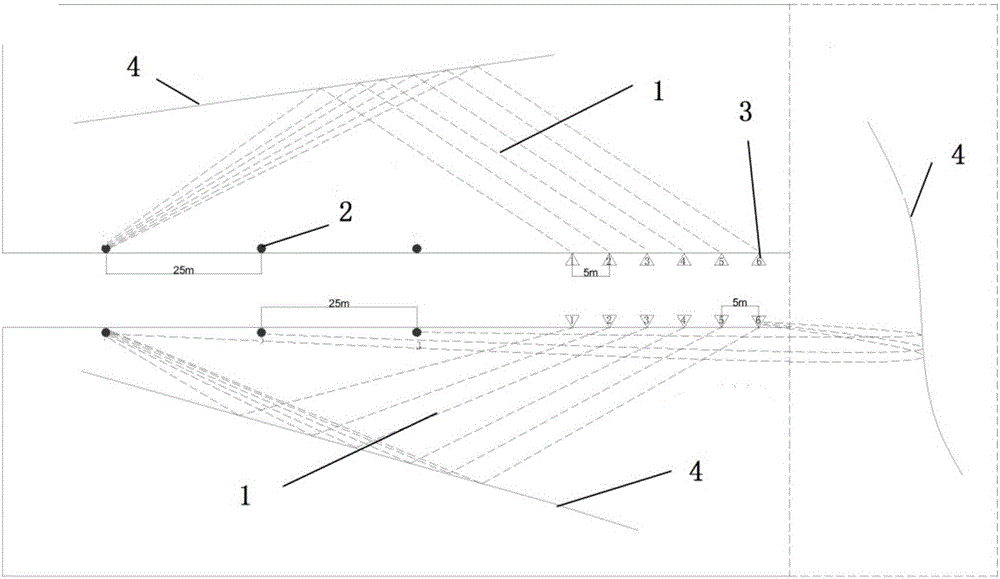
[0029] Such as figure 1 As shown, the embodiment is a typical advanced detection 3D model of a roadway. The model contains 1 roadway. There is a 45-degree inclined fault in front of the tunnel tunnel, and the two sides of the fault are rocks of different formations. Arrange seismic survey lines on the 2 side of the roadway in the model, such as figure 2 The specific positions of stratum 1 and stratum 2 are shown. Through numerical simulation based on the 3D elastic wave equa...


PUM


Abstract

The invention discloses a method for detecting the geological structures of a coal mine excavation roadway in various directions by using excavation signals. The method comprises the following steps of: hardware connection and system arrangement; data acquisition; seismic data preprocessing; data processing analysis and offset imaging; and comprehensive geological interpretation. With the method of the invention adopted, conditions such as coal seam occurrence, geological structures, stress and pressure of a left working face, a right working face and the front of an excavation face can be timely predicted; coal mine geological hazards can be effectively controlled; casualties due to geological causes can be reduced. According to the method of the invention, the coal cutting shock of an excavator is adopted as a seismic origin so that seismic detection is performed, and therefore, normal production arrangements will not be affected, and the method is economical and effective; and the use of explosives is avoided, and construction is securer.

Description

technical field [0001] The present invention is designed in the technical field of coal mine roadway excavation and coal mining, and is mainly used for detecting geological anomalies such as small faults, collapse columns, goafs and scour zones in front of the face of coal mine roadways, and specifically relates to a method for detecting coal mines using excavation-driven signals. The geological structure method in all directions of the roadway. Background technique [0002] It is easy to miss some small structures in the stage of coalfield surface exploration, such as small and medium faults in coal seams, collapse columns, etc. These small structures are difficult to find in the stage of coalfield general survey and exploration or even mining area detailed survey, whether it is drilling or other geophysical methods. Accuracy, the effect is not obvious, and the cost increase caused by increasing the accuracy of ground exploration is huge. These geological structures in the ...

Claims


Application Information

Patent Timeline
IPC IPC(8): G01V1/145G01V1/28G01V1/30
CPCG01V1/145G01V1/288G01V1/302G01V1/306G01V2210/1232G01V2210/324G01V2210/44G01V2210/48G01V2210/624
Inventor 何良李志勇
Owner 北京中矿大地地球探测工程技术有限公司
Why Eureka
Try Eureka