Intelligent scheduling and monitoring method for UAV swarms

An intelligent dispatching, unmanned aerial vehicle technology, applied in control/regulation systems, vehicle position/route/altitude control, instruments, etc., can solve the problems of limiting disaster rescue assessment, emergency control processing, inability to achieve interaction, loss, etc. Achieve the effect of rationally allocating flight area and flight time, realizing timely replenishment of electric energy, and avoiding leakage side problems.

Active Publication Date: 2020-07-10
ZHENGZHOU SHUANGJIE TECH CO LTD
View PDF8 Cites 0 Cited by
  • Summary
  • Abstract
  • Description
  • Claims
  • Application Information

AI Technical Summary

Problems solved by technology

When users use drones for aerial photography and other applications, they usually use the drone to shoot the current environmental scene, and save the captured environmental images in the memory card. The captured environmental image, although this method can capture the required environmental image, but the user needs to wait until the drone has finished shooting the entire process to obtain the required environmental image from the memory card, and cannot know in time what the drone is. The content of the shooting cannot monitor and operate the drone in real time
Due to the frequent occurrence of various natural disasters and emergencies, if the progress of the situation cannot be understood in time, it will seriously limit the rescue assessment of disasters and the control and handling of emergencies, resulting in more serious casualties and economic losses
[0003] On the other hand, the amount of image information formed by UAV photography is very large. Considering the equipment cost and self-weight of the equipment, the existing UAV cannot realize long-distance transmission, and the UAV installed with wireless communication can only In areas with strong signal, data can be transmitted via wife or bluetooth
Cause communication delay reception problem, can not achieve interaction, can not achieve the purpose of real-time monitoring
[0004]Thirdly, the existing unmanned monitoring methods through drones can only be used for the monitoring of small-scale areas. When faced with large-scale and ultra-long-distance monitoring, It is impossible to automatically realize the regional and time coordination of multiple sorties
And it is unavoidable to avoid the occurrence of blind spots and repeated monitoring
However, in the existing technology, the monitoring methods used to achieve wide range and no dead angle are mostly used to improve the mileage performance of multi-helix helicopter UAVs, increase the number of take-off sorties for frequent monitoring and simultaneous monitoring
In fact, no matter how the flight mileage of the helicopter UAV increases, there is a range limit, and it must return in time to recharge in the end
Especially when faced with a fault problem and must make an emergency landing or return, the monitoring effect will be greatly affected

Method used


Image

  • Intelligent scheduling and monitoring method for UAV swarms
  • Intelligent scheduling and monitoring method for UAV swarms

Examples


Embodiment 1

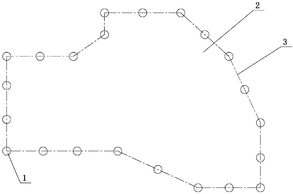
[0015] Embodiment 1: A kind of unmanned aerial vehicle swarm intelligent scheduling monitoring method, see figure 1 , multiple communication platforms are set on the edge of the monitored area, usually evenly spaced at equal intervals. The communication platform is equipped with wireless communication equipment that can transmit image information with the drone. Since the drone continuously records and stores a large amount of data through the high-definition camera, it is not easy to transmit through the wireless network (wireless network transmission not only has poor signal stability, but also requires a lot of traffic. large and expensive). When the drone is close to a communication platform, the image information transmission in the local area network can be established with the drone through the wife to ensure fast and efficient data transmission. The drone adopts a multi-helix drone, which can control the flight speed and stay in the air. When the drone passes through ...

Embodiment 2

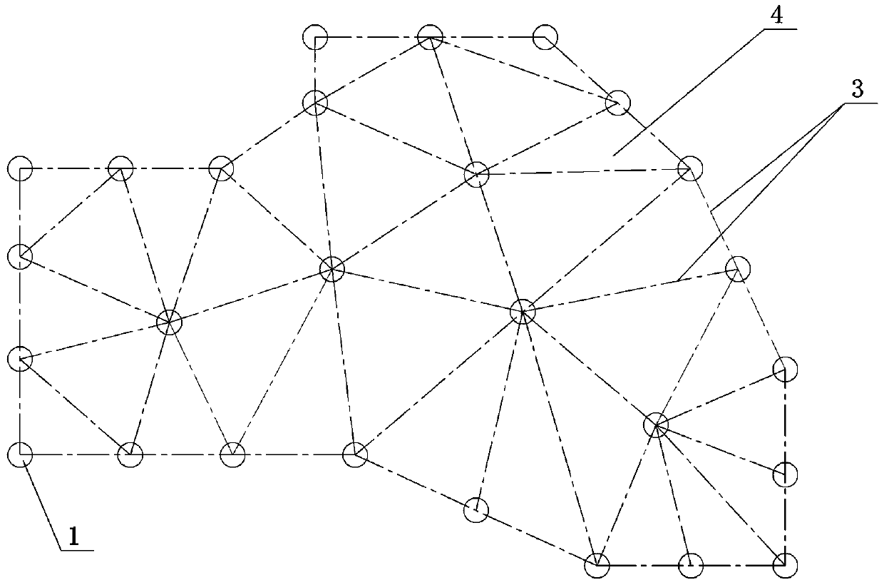
[0023] Embodiment 2: another kind of unmanned aerial vehicle swarm intelligent scheduling monitoring method, see figure 2 , a plurality of communication platforms are arranged on the edge or internal interval of the monitored area, and the monitored area is divided into a plurality of monitoring areas. When performing wireless monitoring tasks, start multiple drones at the same time for monitoring, coordinate the time points and flight routes of multiple drones passing through the monitored area, and ensure that each drone does not pass through the same monitored area at the same time area, and each UAV covers all monitored areas within the specified time.


PUM


Abstract

The invention discloses an unmanned aerial vehicle group intelligent scheduling monitoring method. According to the invention, n communication platforms are arranged at intervals on the edges of or inside a monitored region so that the monitored region is divided into p monitored regions. The communication platforms are provided with wireless communication devices capable of conducting image information transmission with the unmanned aerial vehicles and devices capable of transmitting with a general server either in a wired manner or a wireless manner. The time and flying routes across the monitored regions of m unmanned aerial vehicles are coordinated so as to ensure that at the same time, the unmanned aerial vehicles fly across different monitored regions. According to the invention, the real-time transmission problem of a great amount of image information can be solved so as to meet the purpose of putting monitoring in place. With the method, the problem of the unmanned aerial vehicles to keep their normal flying state only under the condition of frequency power charging could be solved; the problem for effective scheduling of unmanned aerial vehicles at different times is solved. Therefore, a proper flying region and flying time are realized, and repetitive monitoring and missed detection are avoided.

Description

technical field [0001] The invention belongs to the technical field of aerial photography monitoring and management, and in particular relates to an intelligent dispatching and monitoring method for drone swarms. Background technique [0002] With the development of UAV technology, its applications are becoming wider and wider, and it is indispensable in both civilian and military fields. In particular, the application of aerial photography and monitoring is becoming more and more extensive. UAVs are used as Aerial photography tools have become the mainstream of current development. UAVs can be used in monitoring applications such as aerial photography, forest protection, and disaster investigation. At present, the drones suitable for civilian use are basically multi-helix helicopter drones, equipped with lithium batteries, GPS positioning modules and flight drive modules, as well as shooting equipment and storage devices. When users use drones for aerial photography and o...

Claims


Application Information

Patent Timeline
Patent Type & Authority Patents(China)
IPC IPC(8): G05D1/10
CPCG05D1/104
Inventor 魏鲁双
Owner ZHENGZHOU SHUANGJIE TECH CO LTD
Why Eureka
Try Eureka