Intelligent unmanned aerial vehicle group scheduling and monitoring system

An intelligent dispatching and monitoring system technology, applied in closed-circuit television systems, measuring devices, surveying and navigation, etc., can solve the problems of restricting disaster rescue assessment, emergency control and processing, inability to realize interaction, and huge amount of image information, etc., to achieve reasonable The effect of allocating flight areas and flight times, avoiding leakage side problems, and avoiding repeated monitoring

Active Publication Date: 2017-06-13
ZHENGZHOU SHUANGJIE TECH CO LTD
View PDF19 Cites 5 Cited by
  • Summary
  • Abstract
  • Description
  • Claims
  • Application Information

AI Technical Summary

Problems solved by technology

When users use drones for aerial photography and other applications, they usually use the drone to shoot the current environmental scene, and save the captured environmental images in the memory card. The captured environmental image, although this method can capture the required environmental image, but the user needs to wait until the drone has finished shooting the entire process to obtain the required environmental image from the memory card, and cannot know in time what the drone is. The content of the shooting cannot monitor and operate the drone in real time
Due to the frequent occurrence of various natural disasters and emergencies, if the progress of the situation cannot be understood in time, it will seriously limit the rescue assessment of disasters and the control and handling of emergencies, resulting in more serious casualties and economic losses
[0003] On the other hand, the amount of image information formed by UAV photography is very large. Considering the equipment cost and self-weight of the equipment, the existing UAV cannot realize long-distance transmission, and the UAV installed with wireless communication can only In areas with strong signal, data can be transmitted via wife or bluetooth
Cause communication delay reception problem, can not achieve interaction, can not achieve the purpose of real-time monitoring
[0004]Thirdly, the existing unmanned monitoring methods through drones can only be used for the monitoring of small-scale areas. When faced with large-scale and ultra-long-distance monitoring, It is impossible to automatically realize the regional and time coordination of multiple sorties
And it is unavoidable to avoid the occurrence of blind spots and repeated monitoring
However, in the existing technology, the monitoring methods used to achieve wide range and no dead angle are mostly used to improve the mileage performance of multi-helix helicopter UAVs, increase the number of take-off sorties for frequent monitoring and simultaneous monitoring
In fact, no matter how the flight mileage of the helicopter UAV increases, there is a range limit, and it must return in time to recharge in the end
Especially when faced with a fault problem and must make an emergency landing or return, the monitoring effect will be greatly affected

Method used


Image

  • Intelligent unmanned aerial vehicle group scheduling and monitoring system
  • Intelligent unmanned aerial vehicle group scheduling and monitoring system
  • Intelligent unmanned aerial vehicle group scheduling and monitoring system

Examples


Embodiment 1

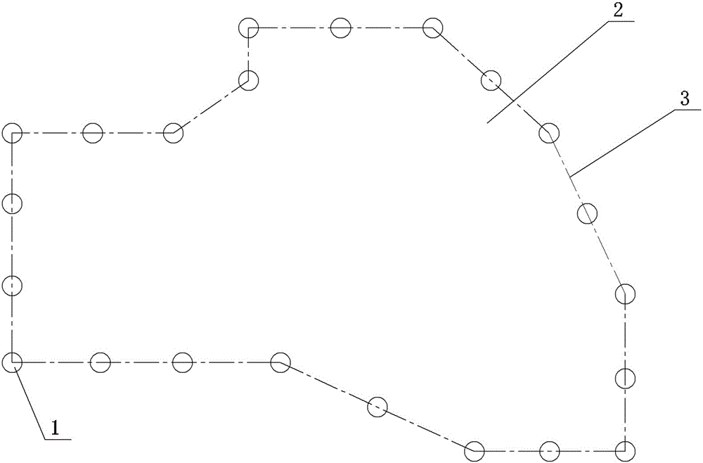
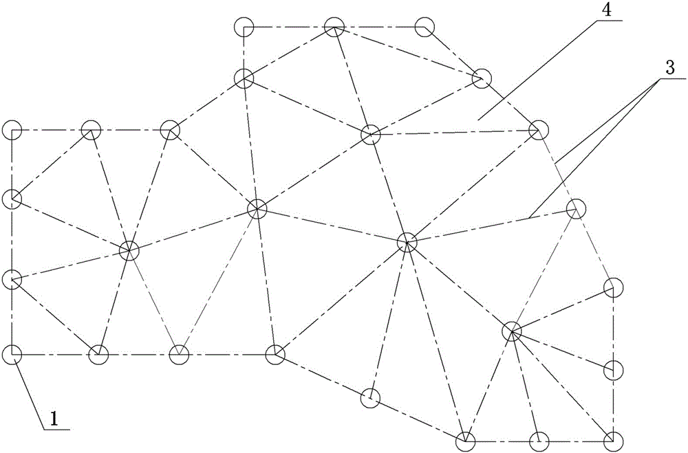
[0026] Embodiment 1: A kind of unmanned aerial vehicle swarm intelligent dispatching monitoring system, see figure 1 or figure 2 , figure 1 A plurality of communication platforms 1 are set on the edge of the monitored area, figure 2 It is to divide the detected area 2 into p monitoring areas. The communication platform 1 is equipped with a wireless communication device capable of transmitting image information with the UAV. Since the UAV continuously records and stores a large amount of data through the high-definition camera, it is not easy to transmit through the wireless network (wireless network transmission not only has poor signal stability, but also requires traffic large and expensive). When the drone is close to a certain communication platform 1, the image information transmission in the local area network can be established with the drone through the wife to ensure fast and efficient data transmission. The drone adopts a multi-helix drone, which can control th...

Embodiment 2

[0034] Embodiment 2: Another intelligent dispatching and monitoring system for UAV swarms. On the basis of Embodiment 1, the wired charging device is modified to a wireless charging device. See Image 6 , the inside of the unmanned aerial vehicle landing platform 7 is provided with an inner cavity, and a charging transmitter coil 38 is installed in the inner cavity, and the charging transmitter coil 38 is connected with the mains through the normally open end of the relay, and whether the coil of the relay is energized will be controlled by the controller.

[0035] see Figure 7 with Figure 8 A base 31 is clamped on the parallel rod bracket at the bottom of the drone, and a charging receiving coil 33 is arranged inside the base 31 . The base 31 on the parallel bar bracket 36 at the bottom of the drone is provided with a draw-in groove 30, and the upper part of the draw-in groove 30 is provided with a fastener 32, and one end of the fastener 32 is hinged on the side wall of t...

Embodiment 3

[0040] Embodiment 3: Another UAV swarm intelligent dispatching and monitoring system, which is improved on the basis of Embodiment 1 or Embodiment 2. The difference from Embodiment 1 or Embodiment 2 is that Embodiment 1 or Embodiment 2 The fixed communication platform is adopted, and the mobile communication platform is adopted in this embodiment.

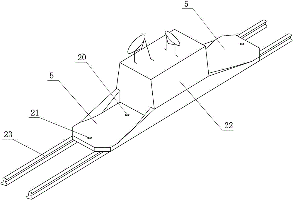
[0041] see Figure 8 As shown, the mobile communication platform includes a car body and a track 23 with a driving force, and the track wheels at the bottom of the car body 22 of the mobile communication platform are matched and installed on the track 23; wireless communication equipment and a GPS positioning module are arranged in the car body and a power supply module; the wireless communication device is used to establish long-distance communication with the server and short-distance communication with the UAV; the side of the car body is provided with a UAV lifting platform. The front end and the rear end of the unmanned aeria...


PUM


Abstract

The invention discloses an intelligent unmanned aerial vehicle group scheduling and monitoring system. A plurality of communication platforms are arranged on the edge or inside a monitored area at intervals; the communication platforms are provided with wireless communication equipment which can transmit image information with an unmanned aerial vehicle, and equipment for wired or wireless transmission with a host server; time points and flying routes of a plurality of unmanned aerial vehicles flying through the monitored area can be coordinated; a wired charge device or a wireless charge device is adopted as a power charger; and the communication platforms are fixed or moveable communication platforms. By adopting the intelligent unmanned aerial vehicle group scheduling and monitoring system, the problem of real-time transmission of massive image information can be solved, and thus the purpose of monitoring can be met. The problem that the unmanned aerial vehicles need to be charged frequently to keep a normal fly state can be solved. The problem that multiple unmanned aerial vehicles cannot be effectively scheduled at different moments can be solved, the purpose that flying areas and flying time are reasonably allocated can be achieved, and repeated monitoring and monitoring omission can be avoided.

Description

technical field [0001] The invention belongs to the technical field of aerial photography monitoring and management, and in particular relates to an intelligent dispatching and monitoring system for unmanned aerial vehicles. Background technique [0002] With the development of UAV technology, its applications are becoming wider and wider, and it is indispensable in both civilian and military fields. In particular, the application of aerial photography and monitoring is becoming more and more extensive. UAVs are used as Aerial photography tools have become the mainstream of current development. UAVs can be used in monitoring applications such as aerial photography, forest protection, and disaster investigation. At present, the drones suitable for civilian use are basically multi-helix helicopter drones, equipped with lithium batteries, GPS positioning modules and flight drive modules, as well as shooting equipment and storage devices. When users use drones for aerial photo...

Claims


Application Information

Patent Timeline
Patent Type & Authority Applications(China)
IPC IPC(8): G01C11/00H04N7/18
CPCH04N7/18G01C11/00Y02T10/7072Y02T10/70Y02T90/16
Inventor 魏鲁双
Owner ZHENGZHOU SHUANGJIE TECH CO LTD
Why Eureka
Try Eureka