
Arrangement method of ground detector for spaceborne laser altimeter calibration

A laser altimeter and detector technology, which is applied to instruments, radio wave measurement systems, etc., can solve problems such as cumbersome processes of ground detectors

Active Publication Date: 2017-06-20
自然资源部国土卫星遥感应用中心
View PDF3 Cites 7 Cited by
  • Summary
  • Abstract
  • Description
  • Claims
  • Application Information

AI Technical Summary

Problems solved by technology

For some space-borne laser altimeters with low laser pulse repetition frequency, the layout of ground detectors involves a more cumbersome process, and each link needs to be linked together.

Method used


Image

  • Arrangement method of ground detector for spaceborne laser altimeter calibration
  • Arrangement method of ground detector for spaceborne laser altimeter calibration
  • Arrangement method of ground detector for spaceborne laser altimeter calibration

Examples


Embodiment Construction

[0056] The invention will be described more fully below with reference to the accompanying drawings, which illustrate exemplary

[0057] Example.

[0058] According to the embodiment of the present invention, the space-borne laser altimeter can be randomly selected to carry out the ground detector layout work of the on-orbit geometric calibration; preferably, the embodiment of the present invention uses the laser altimeter calibration of the No. 3 02 satellite As an example, the laser detector layout during the on-orbit test is used as an example data, but it is not limited to this. The calibration test of the 02 star laser altimeter on August 9, 2016 was randomly selected as an example, and this test was implemented in strict accordance with the present invention.

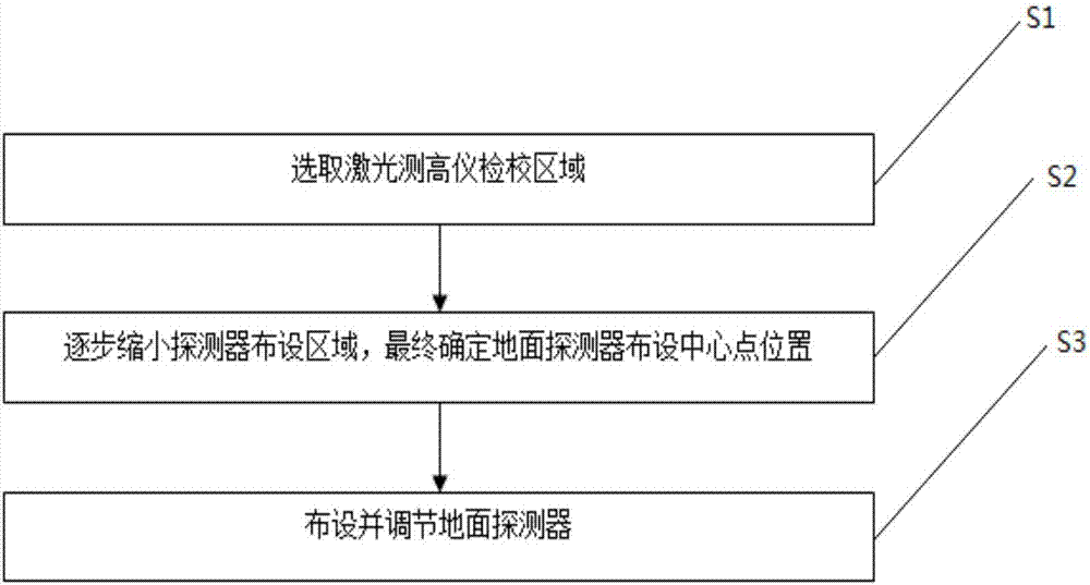
[0059] like figure 1 As shown, the ground detector laying method for spaceborne laser altimeter calibration proposed by the present invention specifically includes three steps:

[0060] S1, select the laser alt...


PUM


Abstract

The invention discloses an arrangement method of a ground detector for spaceborne laser altimeter calibration. The method comprises the following steps that S1, a laser altimeter calibration area is selected; S2, a detector arrangement area is gradually reduced in the laser altimeter calibration area selected in the step S1, and finally the arrangement central point position of the ground detector is determined; and S3, the ground detector is arranged and adjusted at the arrangement central point position of the ground detector determined in the step S2. Implementation of each step is reasonably arranged so that the arrangement efficiency of the detector can be enhanced to a great extent, orderly performing of arrangement of the ground detector can be guaranteed and the working efficiency can be greatly enhanced.

Description

technical field [0001] The invention relates to the field of on-orbit geometric calibration of space-borne laser altimeters, in particular to a layout method for ground detectors used for calibration of space-borne laser altimeters, which is applied to on-orbit geometric calibration of space-borne laser altimeters school test. Background technique [0002] The on-orbit geometric calibration test of the spaceborne laser altimeter is of great significance to improve the accuracy of the laser altimeter, and it is one of the necessary steps before the laser altimeter data participates in the actual production. [0003] At present, the most operable and universal method of on-orbit geometric calibration of spaceborne laser altimeter is the ground detector method, that is, a ground infrared detector array of a certain size is arranged in the ground area where the satellite is about to pass. , to capture the laser spot, and achieve the purpose of calibrating the laser altimeter th...

Claims


Application Information

Patent Timeline
Patent Type & Authority Applications(China)
IPC IPC(8): G01S7/497
CPCG01S7/497
Inventor 唐新明付兴科谢俊峰窦显辉莫凡范大昭高小明朱广彬唐洪钊王甄铭
Owner 自然资源部国土卫星遥感应用中心
Learn More