Unmanned aerial vehicle positioning method based on computer vision

A technology of computer vision and positioning method, applied in the field of unmanned aerial vehicles, can solve the problems of lack of inspection operation ability, low safety of unmanned aerial vehicle line inspection, and inability to achieve precise positioning, so as to reduce the complexity of manual manipulation, The effect of improving the level of operation intelligence and reducing the risk of serious consequences

Inactive Publication Date: 2017-06-27
SICHUAN POWER EHV OVERHAUL
View PDF4 Cites 14 Cited by
  • Summary
  • Abstract
  • Description
  • Claims
  • Application Information

AI Technical Summary

Problems solved by technology

At present, many areas where power transmission lines are located belong to signal blocking areas. When drones fly into these signal blocking areas, the existing positioning technology does not have the ability to conduct inspections under non-visual conditions, and cannot achieve accurate positioning. Moreover, the existing UAV positioning technology is highly dependent on the operator. Misoperation by the operator can easily lead to serious consequences, and the safety of UAV line inspection is low.

Method used


Image

  • Unmanned aerial vehicle positioning method based on computer vision
  • Unmanned aerial vehicle positioning method based on computer vision
  • Unmanned aerial vehicle positioning method based on computer vision

Examples


Embodiment

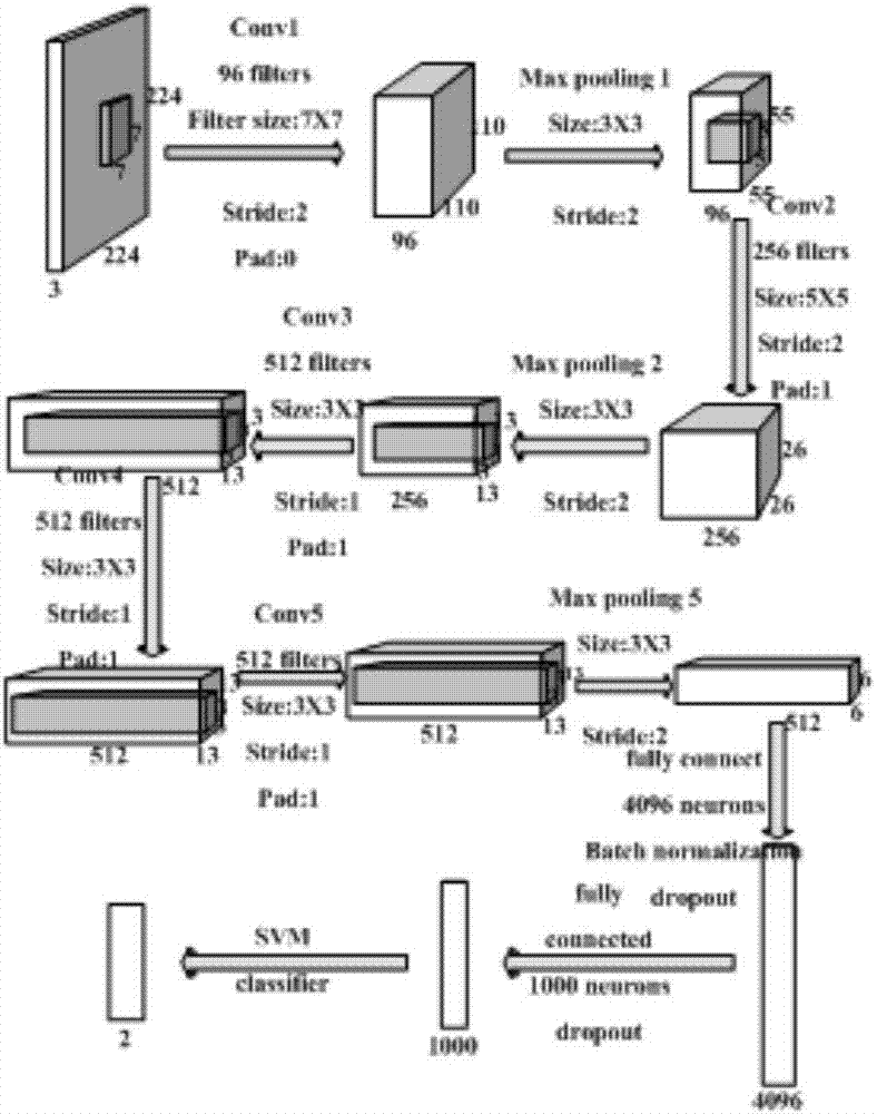
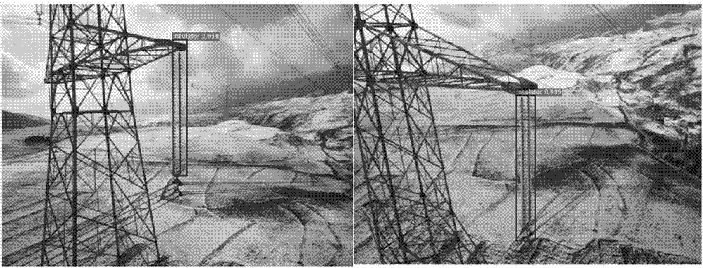
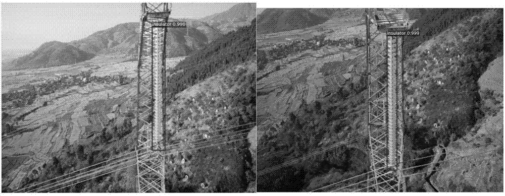
[0057] Using drones, samples were collected from insulators on different transmission lines in different seasons. The training samples are 4000 aerial images of insulators, including 2000 images of glass insulators and 2000 images of porcelain insulators. A convolutional neural network is used to train the disc-shaped suspension porcelain and disc-shaped suspension glass insulators to be detected. In order to reduce the workload of labeling, each selected training sample only contains a pair of insulator strings, showing horizontal, vertical and angular distributions respectively.


PUM


Abstract

The invention discloses an unmanned aerial vehicle positioning method based on computer vision capable of realizing local precise positioning in a signal barrier region. The unmanned aerial vehicle positioning method based on computer vision realizes local precise positioning of an unmanned aerial vehicle by combining a computer vision technology with a pseudo phase distance ranging technology, endows the unmanned aerial vehicle with a work capacity in a non-intervisible environment and changes the condition that an existing unmanned aerial vehicle only can be operated and transmit videos in an intervisible environment, and further extends the work distance of the unmanned aerial vehicle and extends the adaptive capacity of the operating condition. Meanwhile, dependence of the unmanned aerial vehicle on an operator is reduced greatly, so that the complexity of manual operation is reduced. More operating tasks are dehumanized, the risk of severe consequences due to microoperation of the operator is greatly reduced, the safety of line patrol of the unmanned aerial vehicle is enhanced, and the operating intelligent level of the unmanned aerial vehicle can be greatly enhanced. The method is of practical significance in enhancing the integral level of a patrol operation. The method is suitable for being popularized and applied in the technical field of unmanned aerial vehicle.

Description

technical field [0001] The invention relates to the technical field of unmanned aerial vehicles, in particular to a computer vision-based positioning method of unmanned aerial vehicles. Background technique [0002] With the introduction of new technologies, new methods and new management concepts, UAVs have gradually gained attention and have begun to be used in power transmission line inspection operations, making up for the shortcomings of traditional manual inspections to a certain extent, especially in high mountains and other difficult labor. The regional advantage is more obvious. Among them, the UAV has a slow flight speed and has a fixed-point hovering function, which can conduct detailed observation of specific patrol targets, which is conducive to defect discovery. [0003] In harsh environments such as high altitude, low temperature, and no-man’s land, power transmission lines need aerial robots such as drones to participate in operations. They must be independe...

Claims


Application Information

Patent Timeline
Patent Type & Authority Applications(China)
IPC IPC(8): G01C11/00G06K9/00G06K9/62
CPCG01C11/00G01C11/36G06V20/13G06F18/2411
Inventor 杨蔚周辉杨生兰杨颖锐杜毅伍家红赵强
Owner SICHUAN POWER EHV OVERHAUL
Why Eureka
Try Eureka