Accurate one-point positioning method for single-frequency GPS receiver

A GPS receiver, precise single-point positioning technology, applied in the direction of positioning, beacon systems using radio waves, measuring devices, etc.

Active Publication Date: 2009-04-08
杭州亚龙智能科技有限公司
View PDF2 Cites 57 Cited by
  • Summary
  • Abstract
  • Description
  • Claims
  • Application Information

AI Technical Summary

Problems solved by technology

Its disadvantages are: 1) At least two GPS receivers need to be used for synchronous observation, a reference station and a mobile station; 2) There must be a strong spatial correlation between the mobile station and the reference station; 3) The coordinates of the reference station The error will be directly transmitted to the coordinates of the mobile station. When the user switches between several reference stations with different accuracy, the positioning results will be inconsistent.
[0009] 1) Some errors in single-point positioning cannot be eliminated by means of difference, and must be corrected using various models and parameter estimation methods:
[0010] a. The irregularity of the moisture content of the troposphere makes the correction accuracy of the model relatively low, which needs to be determined by parameter estimation;
[0011] b. Double-difference observations cannot be used to eliminate the influence of the ionosphere, and the ionosphere model must be used to weaken its influence, or the half-sum correction of the combination of pseudorange and phase must be used;
[0012] 2) The noise in the observed value is very large, which cannot be detected by the method of combining values, which will inevitably increase the difficulty of cycle slip detection, especially for observations with small cycle slips;
[0013] 3) Since single-station data cannot use double-difference observations to eliminate various errors, model correction cannot completely eliminate various errors, and the ambiguity of non-difference phase observations does not necessarily have integer characteristics, so its ambiguity resolution very difficult

Method used


Image

  • Accurate one-point positioning method for single-frequency GPS receiver
  • Accurate one-point positioning method for single-frequency GPS receiver
  • Accurate one-point positioning method for single-frequency GPS receiver

Examples


Embodiment 1

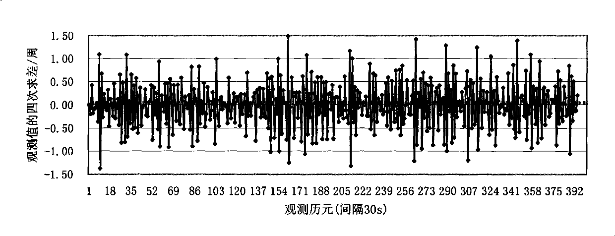
[0124] refer to Figure 12 , a precise single-point positioning method for a single-frequency GPS receiver, comprising a GPS data reading and preprocessing step, an error correction solution step, and a result output step, the preprocessing step including detecting and repairing a cycle slip, The detection and repair steps of the cycle slip include:

[0125] 1) The m carrier phase observations without cycle slip φ i Bring into formula (1) for polynomial fitting;

[0126] i=1,2,...m; m>(n+1)

[0127] (1)

[0128] The polynomial coefficients in the formula are obtained by the least square method, and according to the fitted residual V i Calculate the error:

[0129] σ ( j ) = V i V i m -...

Embodiment 2~3

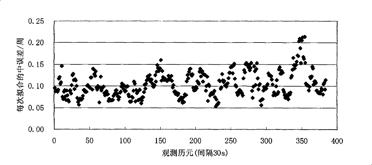
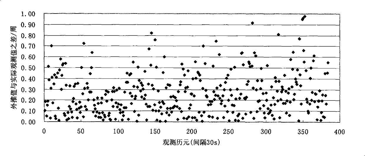
[0224] Examples 2-3: Comparison of solution accuracy between grid model and semi-sum correction method

[0225] In this embodiment, the data of IGS tracking stations BJFS (bjfs0150.07O) and WUHN (wuhn0150.07O) on January 15, 2007 are respectively solved by ionospheric grid model and half-sum correction method. In the data processing, only the L1 and C / A code data in the observed values ​​are used for the calculation of the data of the IGS tracking station. Statistical results such as Figure 8-11 shown.

[0226] As can be seen from the figure:

[0227] 1) Using the grid model to correct, the accuracy of 5 decimeters can be achieved in the N and E directions. But the accuracy in the U direction is about 1 meter;

[0228] 2) Using the semi-sum correction, the accuracy of about 2 decimeters can be achieved in the N, E, and U directions;

[0229] 3) It is obvious that the semi-sum correction method achieves higher accuracy than the grid model correction method. The main reas...


PUM


Abstract

The invention relates to a precise single point positioning method of a single-frequency GPS receiver, which comprises GPS data reading and pretreating steps, error correcting and resolving steps and a result output step, wherein the pretreating step comprises the cycle slip exploration and restoration which comprises the following steps: (1) m non-cycle-slip carrier phase observed values Phi are substituted into a formula and the polynomial fitting is then carried out; (2) a calculated polynomial coefficient is used for extrapolating a carrier phase observed value Phi of the next epoch which is then compared with the actual observed value Phi; (3) the carrier phase observed values of the first epoch and the i-1 epoch are utilized to obtain the variance ratio of the carrier phase observed values. The invention comprehensively utilizes the polynomial fitting method and the carrier phase variance ratio method to explore the cycle slip, combines the gross error correction to realize the precise single point positioning of a single-frequency GPS receiver, thereby effectively realizing the high-precision positioning and navigation of a GPS system.

Description

(1) Technical field [0001] The invention relates to a precise single-point positioning method for a single-frequency GPS receiver. (2) Background technology [0002] The GPS global positioning system is the abbreviation of the acronym NAVSTAR / GPS of the English "Navigation Satellite Timing And Ranging / Global Positioning System". It is a new generation of satellite navigation system developed by the U.S. Department of Defense in the 1970s. It is a satellite-based radio navigation and positioning system with omnipotence (land, ocean, aviation and aerospace), global, all-weather, continuity and Real-time navigation, positioning and timing functions can provide various users with precise three-dimensional positioning, speed measurement and time services. At present, GPS, as a new generation of satellite navigation and positioning system, has been widely used in the fields of military, transportation, surveying and mapping, high-precision time comparison, and resource investigat...

Claims


Application Information

Patent Timeline
Patent Type & Authority Applications(China)
IPC IPC(8): G01S1/02G01S5/02
Inventor 徐慧英朱信忠姚宜斌赵建民罗峰
Owner 杭州亚龙智能科技有限公司
Why Eureka
Try Eureka