NEXT series product OMAP and FPGA calculation system

A computing system and series product technology, applied in the field of navigation systems, can solve the problems of inability to complete navigation independently, low long-term navigation accuracy, and fast error divergence, and achieve the advantages of abundant I/O resources, fast computing speed, and powerful logic control capabilities. Effect

Inactive Publication Date: 2017-08-04
JIANGXI CRYSTAL BIOSENSOR TECH
View PDF0 Cites 1 Cited by
  • Summary
  • Abstract
  • Description
  • Claims
  • Application Information

AI Technical Summary

Problems solved by technology

[0006] The long-term navigation accuracy of the micro-inertial system is low, the error diverges quickly, and the navigation can

Method used


Image

  • NEXT series product OMAP and FPGA calculation system
  • NEXT series product OMAP and FPGA calculation system
  • NEXT series product OMAP and FPGA calculation system

Examples


Embodiment Construction

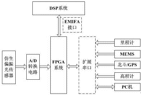
[0033] The specific embodiment of the present invention is: described a kind of NEXT series product OMAP and FPGA computing system, first, A / D conversion circuit converts the polarized light signal that bionic polarized light sensor collects into digital quantity, and MEMS data is input together FPGA system, the FPGA system integrates and preprocesses the data and inputs it into the DSP system through the EMIFA interface, and the DSP system performs navigation calculation on the received data, and then can obtain the speed and position information required for navigation, and input the altimeter information into the DSP system After calculation, the altitude information can be obtained. At the same time, the odometer data can be imported into the DSP system to calibrate the navigation calculation to make the calculation result more accurate. Finally, the navigation information can be displayed through the PC. It is used for hardware debugging of the system. Due to weather facto...


PUM

PropertyMeasurementUnit
Snraaaaaaaaaa

Abstract

The invention discloses an NEXT series product OMAP and FPGA calculation system, which consists of an FPGA system, a DSP system, a bionic polarization optical sensor, an A/D conversion circuit, a milemeter, an MEMS, a Big Dipper/GPS, an elevation meter and a PC, wherein the FPGA system is connected with the milemeter, the MEMS, the Big Dipper/GPS, the elevation meter and the PC through expansion serial ports, and is used for system data integration and preprocessing; the DSP system and the FPGA system are in two-way connection through an EMIFA interface of the DSP system, and is used for realizing the navigation calculation of the system; the bionic polarization optical sensor is used for collecting polarization light signals; the elevation meter is used for carrier altitude positioning; the PC is used for outputting attitude angle, speed and position information to realize the combined navigation function. The NEXT series product OMAP and FPGA calculation system has the characteristics that the structure is simple; the integration degree is high; the power consumption is low; the operation speed is high.

Description

technical field [0001] The invention belongs to the specific application of the navigation system field, and in particular relates to a NEXT series product OMAP and FPGA computing system. Background technique [0002] With the development of modern science and technology, the bionic polarized light sensor has become a research hotspot due to its unique advantages, and has been more and more widely used in navigation. Now that devices are becoming smaller and more integrated, micro-inertial measurement units have become the focus of inertial navigation research. Utilizing a Bionic Polarized Light Sensor Aided Micro Inertial Measurement Unit. Not only the scope of application is not limited, but also the error accumulation of inertial devices can be suppressed, so that the navigation accuracy of micro-inertial devices can be further improved. [0003] Abroad, as early as the 1960s, Professor Wehner of the School of Zoology at the University of Zurich in Switzerland studied t...

Claims


Application Information

Patent Timeline
IPC IPC(8): G01C21/20G01S19/48
CPCG01C21/20G01S19/48
Inventor 徐云鹏
Owner JIANGXI CRYSTAL BIOSENSOR TECH
Why Eureka
Try Eureka