
Accumulated snow identification method and system for synchronous satellite remote-sensing sequence images

A technology of synchronous satellite and recognition method, which is applied in the field of remote sensing image classification and recognition, and can solve problems such as complex preprocessing process, difficulty in obtaining satellite data, and difficulty in ensuring consistency in geometric correction

Active Publication Date: 2017-08-18
INST OF REMOTE SENSING & DIGITAL EARTH CHINESE ACADEMY OF SCI
View PDF5 Cites 7 Cited by
  • Summary
  • Abstract
  • Description
  • Claims
  • Application Information

AI Technical Summary

Problems solved by technology

However, these methods have many disadvantages: on the one hand, the preprocessing process is complicated, and different satellite data need to be geometrically corrected, atmospherically corrected, cropped, etc., and the accuracy of the geometric correction of the two data is difficult to ensure extremely high consistency
On the other hand, due to differences in spatial resolution, width, scanning area, etc., it is difficult to obtain two kinds of satellite data in the same area and at the same time, so the practicability of this method is low

Method used


Image

  • Accumulated snow identification method and system for synchronous satellite remote-sensing sequence images
  • Accumulated snow identification method and system for synchronous satellite remote-sensing sequence images
  • Accumulated snow identification method and system for synchronous satellite remote-sensing sequence images

Examples


Embodiment Construction

[0074] The purpose of the present invention is to provide a processing method and system for group intelligence multimodal data.

[0075]In order to make the above objects, features and advantages of the present invention more comprehensible, the present invention will be further described in detail below in conjunction with the accompanying drawings and specific embodiments.

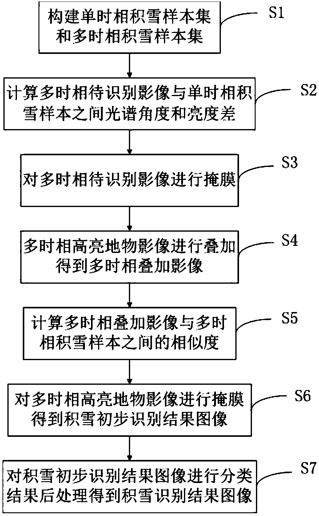
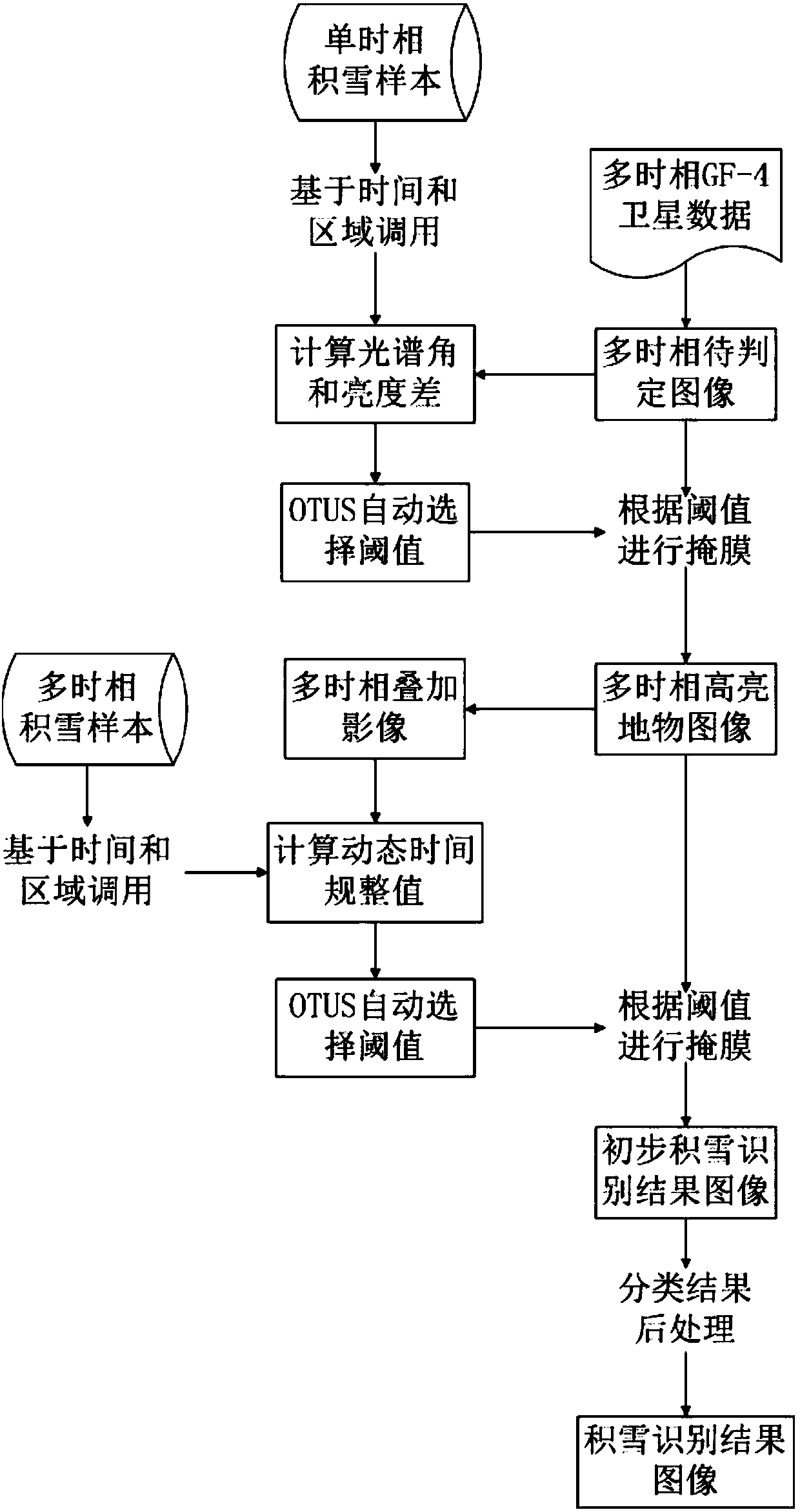
[0076] Such as figure 1 Shown, as a kind of implementable mode, a kind of snow cover identification method of synchronous satellite remote sensing sequence image, comprises the following steps:

[0077] S1. According to the geostationary satellite remote sensing image database, select the snow cover image without cloud information influence, and construct the single-temporal snow cover sample set and the multi-temporal snow cover sample set;

[0078] S2. Randomly select W single-temporal snow samples from the single-temporal snow sample set, and calculate the spectral angle and brightness difference be...


PUM


Abstract

The invention discloses an accumulated snow identification method and a system for synchronous satellite remote-sensing sequence images. Specifically, the method comprises the steps of calculating a spectral angle of a to-be-identified multi-temporal image relative to a single-temporal accumulated snow sample, and calculating the luminance difference between the to-be-identified multi-temporal image and the single-temporal accumulated snow sample; based on the spectral angle and the luminance difference, subjecting the to-be-identified multi-temporal image to mask treatment and generating a multi-temporal high-brightness object image; calculating a dynamic time warping value, and subjecting the multi-temporal high-brightness object image to mask treatment based on the dynamic time warping value so as to generate an accumulated snow preliminary identification result image; based on the accumulated snow preliminary identification result image, obtaining an accumulated snow identification result image by conducting the classification result post-processing method. In this way, the multi-temporal characteristics of synchronous satellite remote-sensing sequence images are fully utilized, while the influence of clouds is eliminated without any short-wave infrared waveband. Therefore, the accumulated snow in synchronous satellite remote-sensing sequence images can be rapidly and accurately identified.

Description

technical field [0001] The invention relates to the field of classification and recognition of remote sensing images, in particular to a snow recognition method and system for synchronous satellite remote sensing sequence images. Background technique [0002] The spatial distribution of snow is an important input factor for hydrological and meteorological models in mountainous and seasonal snow-covered areas. The study of snow distribution and its characteristics is of great significance for atmospheric circulation analysis, climate evolution, water resource utilization and disaster analysis. [0003] Li Sanmei et al. studied the principle of snow cover identification of domestic stationary meteorological satellite FY-2C data, and proposed a snow cover identification method based on the auxiliary factor function of the threshold method, which better solved the difference in the vast area within the full disk of FY-2C. Real-time snow cover monitoring problem under underlying ...

Claims


Application Information

Patent Timeline
IPC IPC(8): G06K9/00G06K9/62
CPCG06V20/13G06F18/22G06F18/24
Inventor 唐娉饶梦彬赵理君张正李艳艳张伟
Owner INST OF REMOTE SENSING & DIGITAL EARTH CHINESE ACADEMY OF SCI
Learn More