Ka-waveband TOPS InSAR system and working method thereof

A ka-band and wave-band technology, applied in the field of synthetic aperture radar imaging, can solve the problem of inability to achieve high-precision and large-scale sea surface height measurement, and achieve the effect of reducing the transmission power requirement and improving the receiving gain.

Inactive Publication Date: 2017-08-29
王辉
View PDF4 Cites 10 Cited by
  • Summary
  • Abstract
  • Description
  • Claims
  • Application Information

AI Technical Summary

Problems solved by technology

[0006] The problem solved by the present invention is that the existing spaceborne SAR interferometric altimetry method cannot realize high-precision and large-scale sea surface height measurement; in order to solve the problem, the present invention provides Ka-band TOPS InSAR system and its working method

Method used


Image

  • Ka-waveband TOPS InSAR system and working method thereof
  • Ka-waveband TOPS InSAR system and working method thereof
  • Ka-waveband TOPS InSAR system and working method thereof

Examples


Embodiment Construction

[0021] Hereinafter, the spirit and essence of the present invention will be further elaborated in conjunction with the drawings and embodiments.

[0022] It can be seen from the background technology that the traditional bottom-view altimeter cannot meet the high-precision requirements of sea surface measurement. The space-borne SAR interferometric altimetry method may require multiple satellites for network measurement, the system is complex and difficult, or the accuracy of single-satellite measurement is limited. The applicant analyzes the above problems, and in the present invention provides a Ka-band TOPS InSAR system and its working method that can obtain centimeter-level high-precision sea surface height data at a width of hundreds of kilometers.

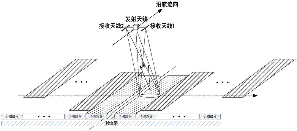
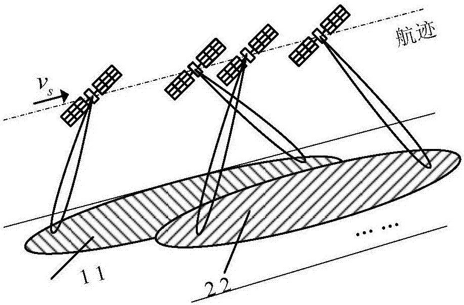
[0023] Such as figure 1 As shown, the Ka-band TOPS InSAR system provided by the present invention includes: a transmitting antenna mounted on a satellite, and on the same star, a first receiving antenna 1 and a second receivi...


PUM


Abstract

The invention discloses a Ka-waveband TOPS InSAR system and a working method thereof. The system comprises a transmitting antenna on a satellite and first and second receiving antennas positioned at the two sides of the transmitting antenna on the same satellite, and the antennas work in the Ka waveband.

Description

technical field [0001] The invention belongs to the technical field of synthetic aperture radar imaging, and in particular relates to a method for realizing a Ka-band TOPS InSAR system. Background technique [0002] With the further development of marine resources in countries around the world, obtaining high-precision marine data information in a large area has become an indispensable part of the utilization of marine resources. Through demand analysis and extensive research on marine data inversion, it is found that in order to obtain effective data products such as sea surface dynamic height, sea surface wave height, sea surface wind speed, seabed topography, ocean thermocline, and convergence area, it is necessary to measure sea surface height. [0003] But the spatial coverage of the traditional bottom-view altimeter is only about 10km. This is because the working principle of the traditional bottom-view altimeter is to transmit a signal to the sea surface, receive the...

Claims


Application Information

Patent Timeline
Patent Type & Authority Applications(China)
IPC IPC(8): G01S13/90
CPCG01S13/90G01S13/9023G01S13/904
Inventor 王辉郑世超姜漫孙志强谢少彪
Owner 王辉
Why Eureka
Try Eureka