Remote sensing image relative radiation correction method and system

A technology for relative radiometric correction and remote sensing images, applied in the field of audio and video, which can solve the problems of reducing the utilization rate of remote signaling data, large differences in image radiation, and difficulty in ensuring image radiation consistency, so as to ensure radiation consistency and strong applicability. , the effect of fast operation

Active Publication Date: 2017-09-29
INST OF REMOTE SENSING & DIGITAL EARTH CHINESE ACADEMY OF SCI
View PDF2 Cites 6 Cited by
  • Summary
  • Abstract
  • Description
  • Claims
  • Application Information

AI Technical Summary

Problems solved by technology

[0004] Although the existing relative radiation correction method can better ensure the radiation consistency between images, there are strict constraints on the image phase: the imaging time of the reference image and the target image are required to be similar, that is, the requirement can be different years, However, the month is required to be within one month, and the imaging time is within one hour. This constraint greatly limits the application of remote sensing data on a national or even global scale for land use and resource analysis. Due to differences and other reasons, the radiation of the image itself is quite different, and it is difficult to ensure the consistency of radiation between images, thus greatly reducing the utilization rate of remote signaling data

Method used


Image

  • Remote sensing image relative radiation correction method and system
  • Remote sensing image relative radiation correction method and system
  • Remote sensing image relative radiation correction method and system

Examples


Embodiment Construction

[0048] The following will clearly and completely describe the technical solutions in the embodiments of the present invention with reference to the accompanying drawings in the embodiments of the present invention. Obviously, the described embodiments are only some, not all, embodiments of the present invention. Based on the embodiments of the present invention, all other embodiments obtained by persons of ordinary skill in the art without making creative efforts belong to the protection scope of the present invention.

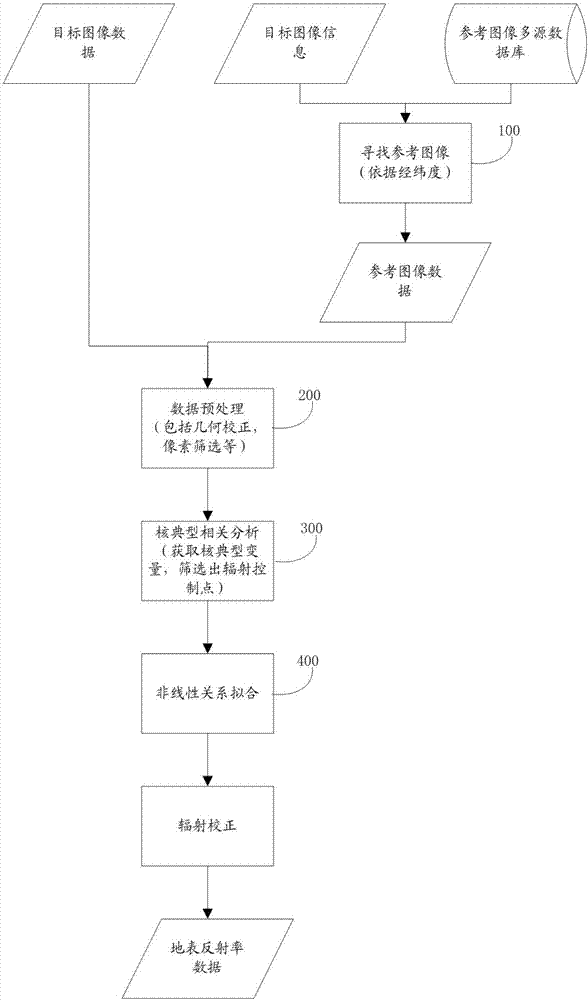
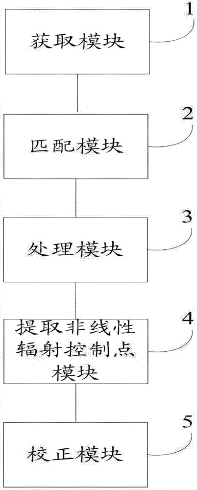
[0049] The object of the present invention is to provide a method and system for relative radiation correction of remote sensing images, so as to ensure the radiation consistency between images and improve the utilization rate of remote signaling data.

[0050] In order to make the above objects, features and advantages of the present invention more comprehensible, the present invention will be further described in detail below in conjunction with the accompany...


PUM


Abstract

The invention discloses a remote sensing image relative radiation correction method and system. The method comprises steps that firstly, a target image is acquired, and a reference image corresponding to the target image is determined according to the target image; secondly, the target image and the reference image are respectively pre-processed to acquire a reference image pixel point set and a target image pixel point set; thirdly, based on a nuclear typical correlation analysis method, a non-linear radiation control point is determined according to the reference image pixel point set and the target image pixel point set; and lastly, pixel points of the target image at each stage are corrected according to the non-linear radiation control point, and a surface reflectance value is acquired. The method is advantaged in that the non-linear radiation control point is determined based on the nuclear typical correlation analysis method, a problem of difficulty in guaranteeing image radiation consistency because of relatively large image radiation difference caused by relatively large time phase difference and sensor imaging geometric difference is solved, and the utilization rate of remote signaling data is substantially improved.

Description

technical field [0001] The invention relates to the field of audio and video technology, in particular to a method and system for relative radiation correction of remote sensing images. Background technique [0002] With the rapid development of remote sensing technology, the use of multi-sensor and multi-temporal remote sensing data for land use and land cover change monitoring, global resource and environment analysis, and climate change monitoring has become more and more widely used, broadening the scope of remote sensing data in time and space. Utilization, such large-area and large-dimensional data applications often have very high requirements for data set consistency, even higher than the accuracy requirements for a single image. [0003] For multi-scene data processing, due to the processing error of each scene data, the difference in acquisition time, and the difference in sensors, etc., after splicing, a "boundary" phenomenon appears near the data splicing line. T...

Claims


Application Information

Patent Timeline
Patent Type & Authority Applications(China)
IPC IPC(8): G06T5/00
CPCG06T5/005G06T2207/10032G06T2207/30181
Inventor 胡昌苗白洋唐娉张正李宏益赵理君
Owner INST OF REMOTE SENSING & DIGITAL EARTH CHINESE ACADEMY OF SCI
Why Eureka
Try Eureka