Optical remote sensing image surface reflectance inversion method based on a reference image library

A technology of surface reflectivity and reference image, applied in image data processing, graphic image conversion, still image data retrieval, etc., can solve the problems of difficult operation, high cost of atmospheric parameters, historical images, calculation of atmospheric parameters, etc.

Active Publication Date: 2019-06-11
INST OF REMOTE SENSING & DIGITAL EARTH CHINESE ACADEMY OF SCI
View PDF3 Cites 0 Cited by
  • Summary
  • Abstract
  • Description
  • Claims
  • Application Information

AI Technical Summary

Problems solved by technology

However, the absolute radiometric correction method requires atmospheric parameters during remote sensing imaging. The cost of synchronously measuring atmospheric parameters is high and it is not suitable for historical images. At the same time, the number of bands of high-resolution optical remote sensing images is small and generally does not contain short-wave infrared (2.1 μm) data. There are methods that are difficult to calculate atmospheric param

Method used


Image

  • Optical remote sensing image surface reflectance inversion method based on a reference image library
  • Optical remote sensing image surface reflectance inversion method based on a reference image library
  • Optical remote sensing image surface reflectance inversion method based on a reference image library

Examples


Embodiment Construction

[0065] The technical solution of the present invention will be further described in detail below in conjunction with the accompanying drawings, but the protection scope of the present invention is not limited to the following description.

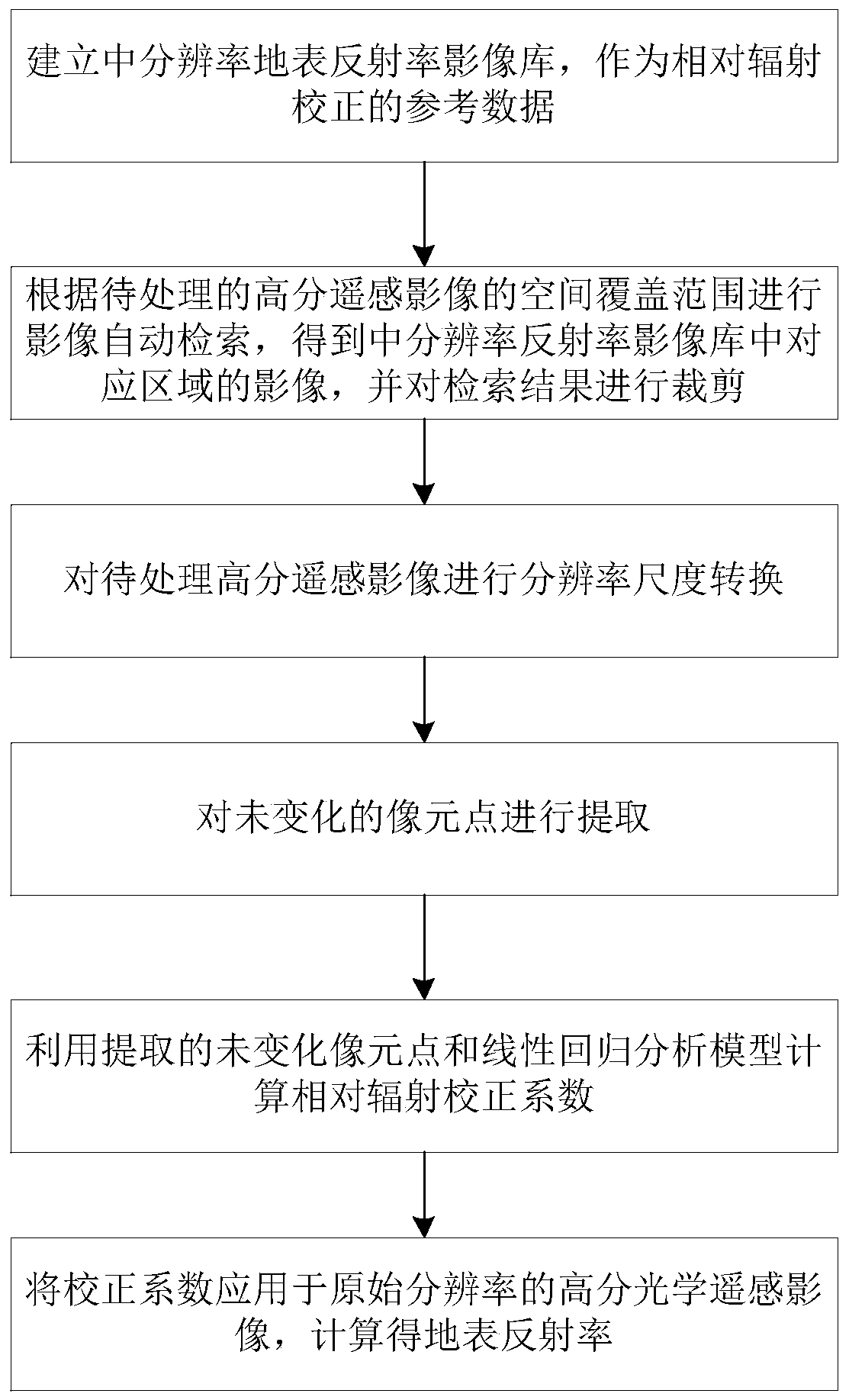
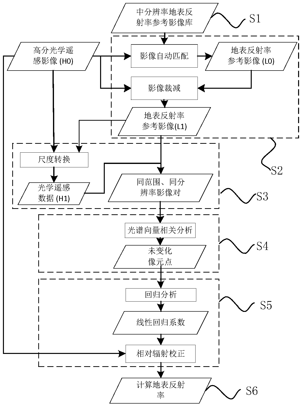
[0066] Such as Figure 1~2 As shown, a surface reflectance retrieval method for optical remote sensing images based on a reference image library includes the following steps:

[0067] S1. Establish a medium-resolution surface reflectance image library as reference data for relative radiometric correction:

[0068] Based on the medium-resolution and multi-spectral Landsat-8 data, a reference image library of surface reflectance was established. Landsat-8 data is the eighth satellite of the US Land Resources series satellite, and its Land Imager (OLI) sensor includes 9 bands, as shown in the table below:

[0069] serial number

band name

Band range (micron)

Spatial resolution (m)

1

Coastal band

0.433–0.453...


PUM


Abstract

The invention discloses an optical remote sensing image surface reflectance inversion method based on a reference image library, and the method comprises the following steps: S1, building a medium-resolution surface reflectance image library, and enabling the medium-resolution surface reflectance image library to serve as reference data of relative radiation correction; S2, automatic image retrieval is carried out according to the spatial coverage of the high-resolution remote sensing image to be processed, an image of a corresponding area in a medium-resolution reflectivity image library is obtained, and a retrieval result is cut; S3, performing resolution scale conversion on the to-be-processed high-resolution remote sensing image; S4, extracting the pixel points which are not changed; S5, calculating a relative radiation correction coefficient by using the invariable pixel point extracted in the step S4 and the linear regression analysis model; And S6, applying the correction coefficient to the high-resolution optical remote sensing image with the original resolution, and calculating to obtain the surface reflectance. The invention provides an optical remote sensing image surface reflectance inversion method based on a reference image library, which is stable in precision and strong in operability, can effectively process large-range and historical archived data, and realizes engineering processing of high-resolution remote sensing image surface reflectance inversion.

Description

technical field [0001] The invention relates to calculation of surface reflectance, in particular to an optical remote sensing image surface reflectance inversion method based on a reference image library. Background technique [0002] In remote sensing science, the element that can reflect the spectral characteristics of ground objects more stably is the reflectance of ground objects, which is one of the essential attributes of ground objects and the basic data for describing remote sensing information. Indispensable basic parameters, has important significance. However, during remote sensing imaging, due to the existence of the atmosphere, the atmospheric molecules, dust, and water vapor contained in the atmosphere absorb and scatter solar radiation, so that the apparent reflectance obtained from the original remote sensing image is inconsistent with the surface reflectance of the target. However, the obtained image data cannot truly reflect the reflection spectrum charac...

Claims


Application Information

Patent Timeline
IPC IPC(8): G06T3/00G06F16/53
Inventor 李利伟胡勇刘良云张兵
Owner INST OF REMOTE SENSING & DIGITAL EARTH CHINESE ACADEMY OF SCI
Why Eureka
Try Eureka