High-precision dynamic map data processing system and method based on roadside sensors

A data processing system and dynamic map technology, applied in the computer field, can solve the problems of low cost, large amount of data and high cost, and achieve the effect of reducing the cost of production

Active Publication Date: 2019-01-25
INST OF SOFTWARE APPL TECH GUANGZHOU & CHINESE ACAD OF SCI
View PDF9 Cites 0 Cited by
  • Summary
  • Abstract
  • Description
  • Claims
  • Application Information

AI Technical Summary

Problems solved by technology

[0012] In view of this, in order to solve the problems of large data volume, difficult processing, high cost and long map update cycle in the map collection method in the prior art, the present invention proposes a high-precision dynamic map data processing system and method based on roadside sensors, High-precision map generation is realized through roadside sensors and AI technology. The cost is low, and the generated results can effectively feed back the current state of road characteristics in real time, providing accurate driving assistance information for automatic driving.

Method used


Image

  • High-precision dynamic map data processing system and method based on roadside sensors
  • High-precision dynamic map data processing system and method based on roadside sensors
  • High-precision dynamic map data processing system and method based on roadside sensors

Examples


Embodiment 1

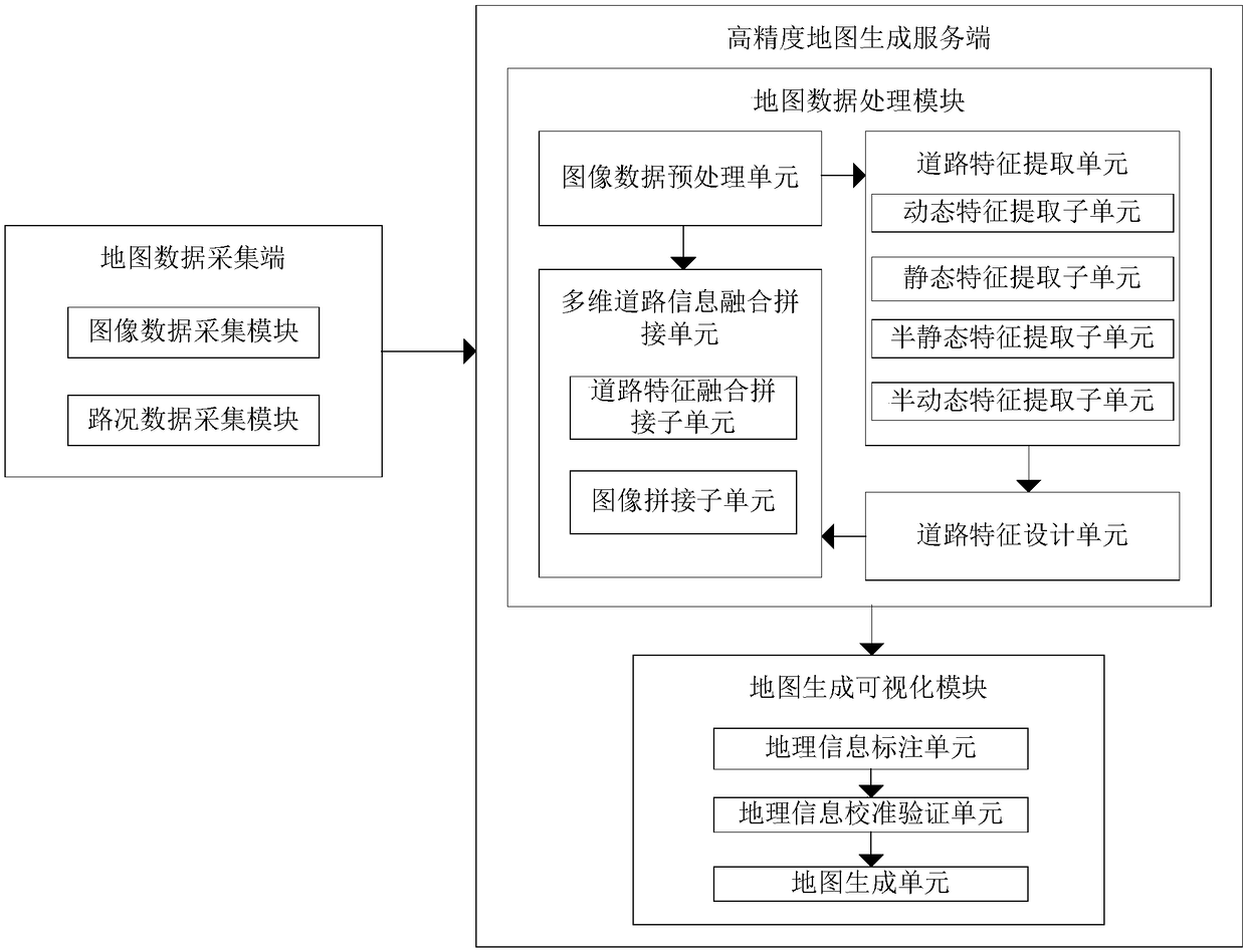
[0068] Such as figure 1 As shown, the present invention provides a high-precision dynamic map data processing system based on roadside sensors, including:

[0069] The map data collection terminal is used to provide massive and diversified map road raw data for the high-precision map generation server;

[0070] The high-precision map generation server is used to generate high-precision dynamic maps based on the massive and diversified map road raw data provided by the map data collection terminal;

[0071] The high-precision map generation server includes:

[0072] The map data processing module is used to extract road features from the original road data of the map, adopt a layered design for all road features, and splicing the same road information, first complete the fusion of road feature data at the road feature level, and finally complete at the image level Image stitching, the result of stitching generates a top view projection map of the road;

[0073] The map gener...

Embodiment 2

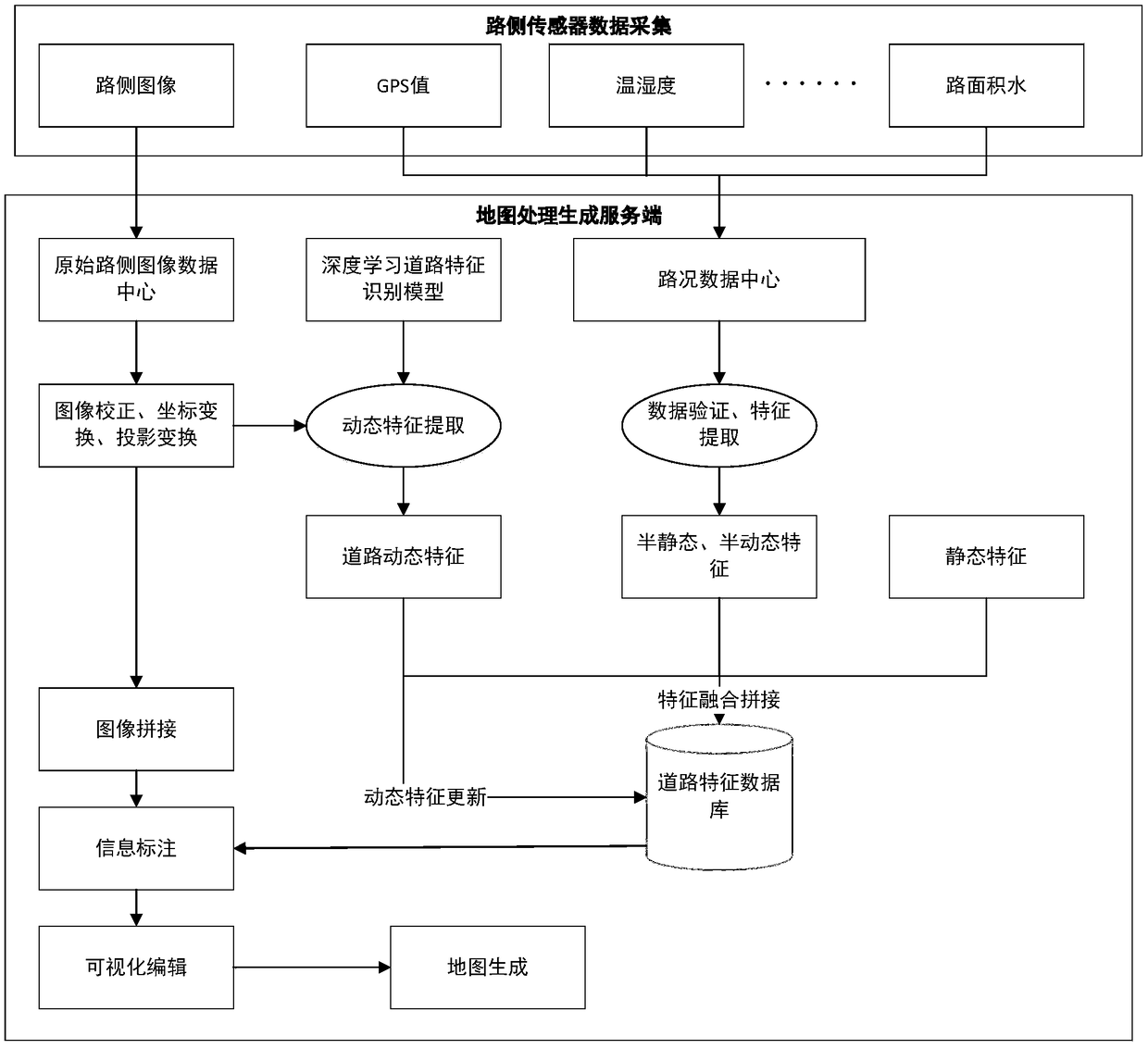
[0114] Such as Figure 5 As shown, the present invention is also a high-precision dynamic map data processing method based on roadside sensors, including:

[0115] S1. Collect a large amount of map original road image data and map original road condition data;

[0116] S2. Perform preprocessing of image correction, image coordinate transformation, and image projection transformation on the original road image data of the map. After the preprocessing, the image overlapping areas collected by the image data acquisition modules at adjacent positions can be aligned;

[0117] S3. Establish a deep learning road dynamic feature recognition model using deep learning and image recognition related AI technologies, and use the deep learning road dynamic feature recognition model to identify road dynamic features from the original road image data on the map;

[0118] Perform refined feature modeling based on existing navigation maps to obtain road static features;

[0119] Through the d...


PUM


Abstract

The invention discloses a system and method for processing high-precision dynamic map data based on roadside sensors. The system includes: a map data acquisition terminal, which provides massive and diversified original map road data for a high-precision map generation server; high-precision The map generation server includes: a map data processing module, which extracts road features from the original road data of the map, adopts a layered design for all road features, splices the same road information, and first completes road feature data fusion at the road feature level, and finally The image stitching is completed at the image level, and the result of the stitching generates a top-view projection map of the road; the map generation visualization module marks the road information on the top-view projection map, and the marked road information and the top-view projection map together form the map data of the high-precision map. Visually edit map data to generate high-precision dynamic maps. The invention can reduce the generation cost of the high-precision map and realize the fast updating of the high-precision dynamic map.

Description

technical field [0001] The invention relates to the field of computer technology, in particular to a high-precision dynamic map data processing system and method based on roadside sensors. Background technique [0002] At present, with the rapid development of autonomous driving technology, the importance of high-precision maps has become increasingly prominent, and has become an indispensable part of realizing unmanned driving and intelligent transportation. The accuracy of existing navigation maps is generally not high, and the entire road is used as an object to provide road information data or issue navigation instructions. This kind of navigation map is called a road-level map, which greatly simplifies the actual traffic environment and can provide The information content is small, the accuracy is low, and the ability to assist the driver is low. [0003] The map required for autonomous driving must not only have high precision, but also have a large number of rich det...

Claims


Application Information

Patent Timeline
Patent Type & Authority Patents(China)
IPC IPC(8): G06F16/29G06K9/00G08G1/0967
CPCG06F16/29G08G1/096783G06V20/54
Inventor 陈春艳陈升东崔莹袁峰陆聪
Owner INST OF SOFTWARE APPL TECH GUANGZHOU & CHINESE ACAD OF SCI
Why Eureka
Try Eureka