
A system and method for calculating the moving distance of an unmanned aerial vehicle

A technology of moving distance and calculation system, which is applied in the direction of control/regulation system, non-electric variable control, instrument, etc., and can solve the problems of unmanned stable control and inconsistent recognition of translation amount

Active Publication Date: 2020-05-08
GEER TECH CO LTD
View PDF6 Cites 0 Cited by
  • Summary
  • Abstract
  • Description
  • Claims
  • Application Information

AI Technical Summary

Problems solved by technology

[0006] The purpose of the present invention is to provide a system and method for calculating the moving distance of the UAV, which solves the problem of inconsistency in the recognition of the translation amount when the UAV is flying at different heights, so that the flying distance of the UAV can be accurately calculated, and the distance of the UAV can be accurately calculated. The purpose of human stability control

Method used


Image

  • A system and method for calculating the moving distance of an unmanned aerial vehicle
  • A system and method for calculating the moving distance of an unmanned aerial vehicle
  • A system and method for calculating the moving distance of an unmanned aerial vehicle

Examples


Embodiment Construction

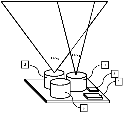
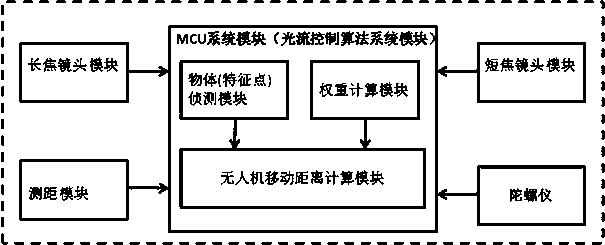
[0014] Such as figure 1 , 3 As shown, the UAV moving distance calculation system in this embodiment includes a telephoto lens module 1, a short-focus lens module 2, a ranging module 3, an optical flow control algorithm system module (MCU system module) 4 and a gyroscope 5. Each module is described in detail below:

[0015] The telephoto lens module 1 is used to provide the image acquired by the telephoto lens to the optical flow control algorithm system module 4 .

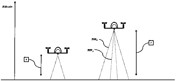
[0016] When the telephoto lens is determined, the resolution R of the telephoto lens 1 To determine the value, the angle of view FOV of the telephoto lens 1 to determine the value. Therefore, for the telephoto lens, the moving distance D of the drone calculated by the telephoto lens based on two frames of images 1 =P 1 / R 1 (H*2.0*tan(FOV 1 / 2)), P 1 is the amount of pixels moved by the object on the telephoto lens compared with the previous frame image, and H is the height of the drone obtained by the ran...


PUM


Abstract

The invention discloses a displacement distance calculation system and method for an unmanned aerial vehicle. Reasonable weights of a telephoto lens and a short lens are calculated by utilizing the difference of differentiation degrees of images of the lenses on a sensor when the telephoto lens and the short lens have different heights, then the unmanned aerial vehicle system can change calculation weights of the telephoto lens and the short lens according to different flight heights, so that an aircraft can keep extremely high differentiation degree at different flight heights relative to translation amounts in directions X and Y, and the problem that the differentiation degrees of the translation amounts are inconsistent on different flight heights is solved. Therefore, the flight distance of the unmanned aerial vehicle can be accurately calculated, and the aim of stably controlling the unmanned aerial vehicle is achieved.

Description

technical field [0001] The invention belongs to the technical field of unmanned aerial vehicles, and in particular relates to a system and method for calculating the moving distance of an unmanned aerial vehicle. Background technique [0002] Most of the existing optical flow vision modules for aircraft positioning are designed by combining the image module and the distance measurement module. value. [0003] If the image module adopts a single lens, when the flying altitude (Altitude) is high, the resolution (Pixel) of the image module for the distance (Distance) in the X and Y directions will decrease. From the following simple XY movement amount calculation formula, it can be seen that the calculated movement amount will have errors. [0004] [0005] If the image module adopts dual lenses, that is, a long-focus lens and a short-focus lens, the short-focus lens can obtain more scene information, but the recognition degree is low when the object distance is far away, ...

Claims


Application Information

Patent Timeline
Patent Type & Authority Patents(China)
IPC IPC(8): G05D1/08G05D1/10
CPCG05D1/0808G05D1/101
Inventor 黎凡炜蔡朝链林敬顺
Owner GEER TECH CO LTD
Learn More