Calculation method of fire point alarm distance for overhead transmission line mountain fire satellite monitoring
What is AI technical title?
AI technical title is built by Patsnap AI team. It summarizes the technical point description of the patent document.
A technology for overhead transmission lines and transmission lines, which is applied to fire alarms, forest fire alarms, alarms, etc., to achieve strong applicability
Active Publication Date: 2016-06-08
STATE GRID CORP OF CHINA +2
View PDF6 Cites 0 Cited by
Summary
Abstract
Description
Claims
Application Information
AI Technical Summary
This helps you quickly interpret patents by identifying the three key elements:
Problems solved by technology
Method used
Benefits of technology
Problems solved by technology
[0004] The technical problem to be solved by the present invention is to overcome the limitations of existing technologies in application, and propose a method that is accurate in calculation, avoids calculation errors, is not affected by regional changes, and greatly improves the alarm calculation of existing satellite mountain fire monitoring systems. Calculation method of fire point alarm distance for mountain fire satellite monitoring of overhead transmission lines with high accuracy
Method used
Image
Click on the blue label to locate the original text in one second.
Reading with bidirectional positioning of images and text.
Examples
Embodiment 1
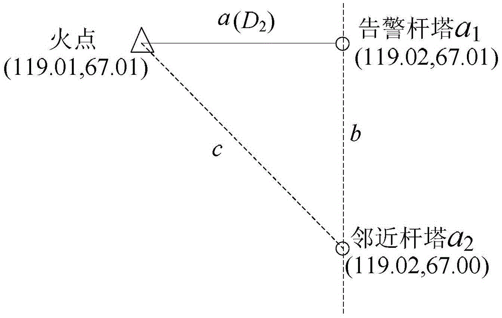
[0064] Calculate the warning distance of the fire point (119.01, 67.01) to the overhead transmission line.
[0065] (1) Calculate the spherical distance between the fire point and the surrounding overhead transmission line towers from the formula (1), and find the alarm tower closest to the fire point based on the distance a 1 , Its coordinates are (119.02, 67.01), the adjacent tower a on the same line as the alarm tower 2 The latitude and longitude coordinates are (119.02, 67.00), see figure 2 . The horizontal distance D from the fire point to the overhead transmission line 2 The calculation process is as follows:
[0066] First, convert the above three latitude and longitude coordinates into radians, namely:
[0067] (lon 0 , Lat 0 )=(2.077116343, 1.169545132);
[0068] (lon 1 , Lat 1 )=(2.077290876, 1.169545132);
[0069] (lon 2 , Lat 2 ) = (2.077290876, 1.169370599).
[0070] Substituting formulas (1)~(2) to calculate:
[0071] a=434.29;
[0072] b=1111.95;
[0073] c=1193.78;
[0074]...
Embodiment 2
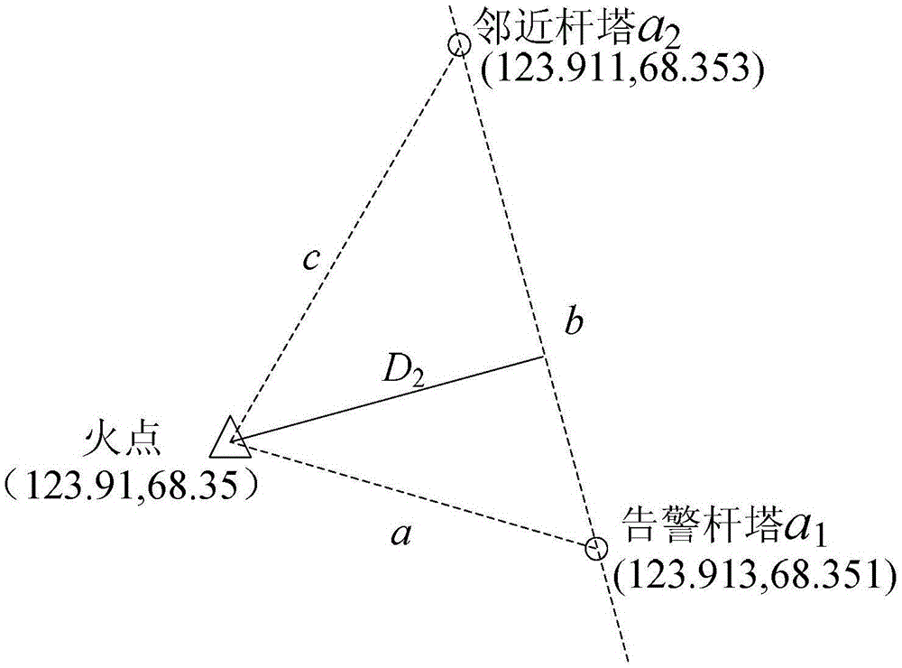
[0080] Calculate the warning distance of the fire point (123.91, 68.35) to the overhead transmission line.
[0081] (1). Calculate the spherical distance between the fire point and the surrounding overhead transmission line towers from the formula (1), and find the alarm tower closest to the fire point based on the distance 1 , Its coordinates are (123.913, 68.351), the adjacent tower a on the same line as the alarm tower 2 The latitude and longitude coordinates are (123.911, 68.353), see image 3 . The horizontal distance D from the fire point to the overhead transmission line 2 The calculation process is as follows:
[0082] First, convert the above three latitude and longitude coordinates into radians, namely:
[0083] (lon 0 , Lat 0 )=(2.162637476,1.192932544);
[0084] (lon 1 , Lat 1 )=(2.162689836, 1.192949997);
[0085] (lon 2 , Lat 2 ) = (2.162654929, 1.192984904).
[0086] Substituting formulas (1)~(2) to calculate:
[0087] a=165.86;
[0088] b=237.04;
[0089] c=336.10;
[0090]...
PUM
Abstract
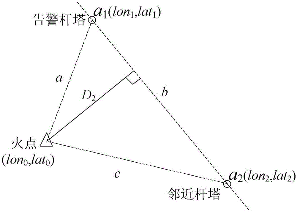
The invention discloses an overhead power transmission line mountain fire satellite monitoring fire point alarming distance calculating method. The method includes: according to satellite monitoring fire point coordinates and coordinates of overhead power transmission line pole towers around, utilizing a calculating formula of spherical distance between two points on the earth to determine an alarming pole tower nearest to a fire point; calculating three sides of an arc-shaped triangle formed by the fire point, the alarming pole tower and an adjacent pole tower on a same line with the alarming pole tower, and accurately calculating horizontal distance between the fire point and a power transmission line according to a planimetry principle, wherein the horizontal distance is alarming distance; determining alarming level according to the alarming distance. The method has the advantages that calculating errors can be avoided, the method is free of influence of region changing, and accuracy in alarming calculation of existing satellite mountain fire monitoring systems is improved greatly.
Description
Technical field [0001] The invention belongs to the technical field of power system disaster prevention and mitigation, and specifically relates to a method for calculating the fire point warning distance of an overhead transmission line wildfire satellite monitoring fire point. Background technique [0002] Wildfires near overhead transmission lines pose a serious threat to the safe and stable operation of the power system. The rapid spread of wildfires has brought huge problems to the prevention and control of wildfires. The use of the transmission line wildfire satellite monitoring system can timely and accurately detect wildfires near the overhead transmission line, and raise an alarm before it spreads below the line, so as to take effective preventive measures in advance. When satellites detect wildfires, in addition to locating the fire, it is also necessary to calculate the distance from the fire to the overhead transmission line to determine the corresponding alarm level...
Claims
Application Information
Patent Timeline
Application Date:The date an application was filed.
Publication Date:The date a patent or application was officially published.
First Publication Date:The earliest publication date of a patent with the same application number.
Issue Date:Publication date of the patent grant document.
PCT Entry Date:The Entry date of PCT National Phase.
Estimated Expiry Date:The statutory expiry date of a patent right according to the Patent Law, and it is the longest term of protection that the patent right can achieve without the termination of the patent right due to other reasons(Term extension factor has been taken into account ).
Invalid Date:Actual expiry date is based on effective date or publication date of legal transaction data of invalid patent.

