
Navigation path division method based on division areas

A navigation path and normalization technology, applied in the field of navigation, can solve problems such as inability to describe

Inactive Publication Date: 2017-10-17
UNIV OF ELECTRONIC SCI & TECH OF CHINA
View PDF0 Cites 0 Cited by
  • Summary
  • Abstract
  • Description
  • Claims
  • Application Information

AI Technical Summary

Problems solved by technology

[0004] The first challenge is how to find landmarks and known trajectories and use them to generate navigation directions that are concise, but convey enough information to interpret the route for the user
[0005] The second challenge is how to consider actual driving using known routes (which can be sparse and potentially contain a large degree of uncertainty)
Therefore, a certain motion behavior cannot be used to describe the entire motion trajectory

Method used


Image

  • Navigation path division method based on division areas
  • Navigation path division method based on division areas
  • Navigation path division method based on division areas

Examples


Embodiment 1

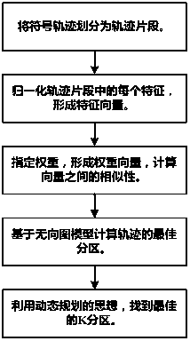
[0051] Such as figure 1 As shown, a partition-based navigation path division method, including:

[0052] label track fragments Track fragments with the same label value divided into the same partition;

[0053] The number of said labels does not exceed indivual;

[0054] If two trajectory fragments are labeled with the same label t, then all trajectory fragments between these two trajectory fragments are labeled with t;

[0055] in, for the sign track The number of landmarks in .

[0056] Further, include:

[0057] will symbol track Modeled as an undirected graph G(V,E), such that each trajectory segment They are all a vertex in the vertex set, and each vertex corresponds to a random variable X i ;

[0058] Assume Using the CRF model:

[0059]

[0060] Compute the best sequence X opt , used to measure the symbolic locus Next label sequence [X 1 ,X 2 ,...,X i ] possibility;

[0061] where Pr is the symbolic locus Under the condition of , the pr...


PUM


Abstract

The invention discloses a navigation path division method based on division areas. The navigation path division method comprises the following steps: marking trajectory fragments with labels and dividing the trajectory fragments with a same label value into the same division area; if the two trajectory fragments are marked by the same label, marking all the trajectory fragments between the two trajectory fragments with the label. According to the navigation path division method disclosed by the invention, road signs of a starting point and a destination of each of the division areas are the most meaningful; meanwhile, the motion characteristic and route characteristic information of each of the division areas is maximally polymerized; the difference between motion characteristics and route characteristics in the same division area is minimized. After being symbolized, an original trajectory forms a symbolic trajectory, and the symbolic trajectory is taken as an input to an algorithm, and an output is a trajectory division result; a navigation path is divided into several division area parts, so that a navigator can respectively provide more accurate feedback information for users at each road section.

Description

technical field [0001] The invention relates to the technical field of navigation, in particular to a method for dividing navigation paths based on partitions. Background technique [0002] A navigation application is an application for finding the best route and corresponding turn-by-turn directions in a road network. The turn-by-turn navigation service provided by existing navigation applications is obtained by extracting information from the bottom road network. So, it can be easily converted into physical world information to tell (how far / how often to turn). But this translation, which ignores human perception of geographic space, is often lengthy for drivers who understand geographic regions. Drivers on most roads have good city knowledge and familiarity with certain parts of the road network, and the routes they take, (for example, a route from home to a nearby road can be summarized in one sentence: from home to XXX road; Instead of: turn left XX meters ahead,.....

Claims


Application Information

Patent Timeline
IPC IPC(8): G01C21/20G01C21/34
CPCG01C21/20G01C21/3446
Inventor 苏涵曾凯郑渤龙杨晨
Owner UNIV OF ELECTRONIC SCI & TECH OF CHINA
Learn More