Expressway real-time monitoring navigation method based on things of internet

A highway, real-time monitoring technology, applied in the field of communication information navigation, can solve the problems of being unable to resist the threat of other vehicles, affecting the driving safety of highways, continuous collisions of multiple vehicles, etc., and achieve the effect of saving travel time

Inactive Publication Date: 2017-10-24
WUXI NANLIGONG TECH DEV
View PDF10 Cites 4 Cited by
  • Summary
  • Abstract
  • Description
  • Claims
  • Application Information

AI Technical Summary

Problems solved by technology

[0002] Car navigators and vehicle travel recorders have been widely used in people's daily life. In addition, vehicle safety assurance systems such as radar vehicle obstacle testers and ultrasonic range finders are constantly emerging, all of which aim to ensure road safety. Driving safety, however, public roads are an open platform, and any driving vehicle cannot resist threats from other vehicles, especially on expressways

Method used


Image

  • Expressway real-time monitoring navigation method based on things of internet

Examples


Embodiment 1

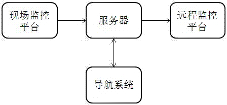
[0025] Embodiment 1: the navigation system of the highway real-time monitoring based on the Internet of Things comprises: highway real-time monitoring system, server and navigation system; Described navigation system and described highway real-time monitoring system all adopt network communication with described server Connect and exchange data; the navigation system includes a GPS positioning module, a storage module, a network communication module, a navigation module, a digital map module, a control module, a voice module and a power supply module, the GPS positioning module, a voice module, a storage module, a network The communication module, the navigation module, the digital map module, and the first power supply module are all connected with the control module, and the real-time monitoring system of the expressway includes an on-site monitoring platform and a remote monitoring center, and the on-site monitoring platform includes a main board, a weather monitoring module,...

Embodiment 2

[0026] Embodiment 2: the navigation system of the highway real-time monitoring based on the Internet of Things comprises: highway real-time monitoring system, server and navigation system; Described navigation system and described highway real-time monitoring system all adopt network communication with described server Connect and exchange data; the navigation system includes a GPS positioning module, a storage module, a network communication module, a navigation module, a digital map module, a control module, a voice module and a power supply module, the GPS positioning module, a voice module, a storage module, a network The communication module, the navigation module, the digital map module, and the first power supply module are all connected with the control module, and the real-time monitoring system of the expressway includes an on-site monitoring platform and a remote monitoring center, and the on-site monitoring platform includes a main board, a weather monitoring module, a...


PUM


Abstract

The invention provides an expressway real-time monitoring navigation method based on things of internet, which includes steps of (1), a network connection, a remote monitoring platform and a field monitoring platform are initialized; (2), a navigation system inquires a route and broadcasts the route by voice to navigate; (3), the field monitoring platform monitors the climate condition of the expressway and accident information monitored by the camera through a climate monitoring module and an environment monitoring module, and transmits the real-time climate information and the accident information to the server through a first network communication module; after being treated by the server; the climate information, the accident information and a command of closing the expressway entrance or not are transmitted to the remote monitoring center, and the weather warning information is broadcasted through the warning voice module; (4), the server transmits the climate information, the accident information and the command of closing the expressway entrance or not to the navigation system at the same time, and the navigation system broadcasts it by voice and timely plans route again for drivers.

Description

technical field [0001] The invention relates to the technical field of communication information navigation, in particular to a navigation system and method for real-time monitoring of highways based on the Internet of Things. Background technique [0002] Car navigators and vehicle travel recorders have been widely used in people's daily life. In addition, vehicle safety assurance systems such as radar vehicle obstacle testers and ultrasonic range finders are constantly emerging, all of which aim to ensure road safety. Driving safety, however, public roads are an open platform, and any driving vehicle cannot resist threats from other vehicles, especially on expressways with a speed of 100 km / h on both sides. At the same time, severe weather phenomena will affect the safety of driving on the expressway, which can easily lead to traffic accidents. In addition, the speed of vehicles on the expressway is relatively fast. Once a traffic accident occurs due to low visibility suc...

Claims


Application Information

Patent Timeline
IPC IPC(8): G01C21/34G01C21/36G01S19/45H04W84/18
CPCG01C21/3415G01C21/3492G01C21/3691G01S19/45H04W84/18
Inventor 李千目侯君
Owner WUXI NANLIGONG TECH DEV
Why Eureka
Try Eureka