A monitoring method based on drones

A technology for unmanned aerial vehicles and monitoring areas, which is applied in control/regulation systems, non-electric variable control, three-dimensional position/channel control, etc. And other issues

Active Publication Date: 2020-07-28
AVIC HUADONG PHOTOELECTRIC SHENZHEN CO LTD
View PDF5 Cites 0 Cited by
  • Summary
  • Abstract
  • Description
  • Claims
  • Application Information

AI Technical Summary

Problems solved by technology

[0004] However, in the solutions of the prior art, if the distance between the starting point and the end point is long, it takes a long time to calculate the navigation path. When there is a temporary path adjustment, the entire navigation path needs to be recalculated, which will take up A lot of computing resources, so the UAV can't work well during operation

Method used


Image

  • A monitoring method based on drones

Examples


Embodiment Construction

[0052] In order to enable those skilled in the art to better understand the technical solutions of the present invention, the present invention will be further described in detail below in conjunction with the accompanying drawings and specific embodiments.

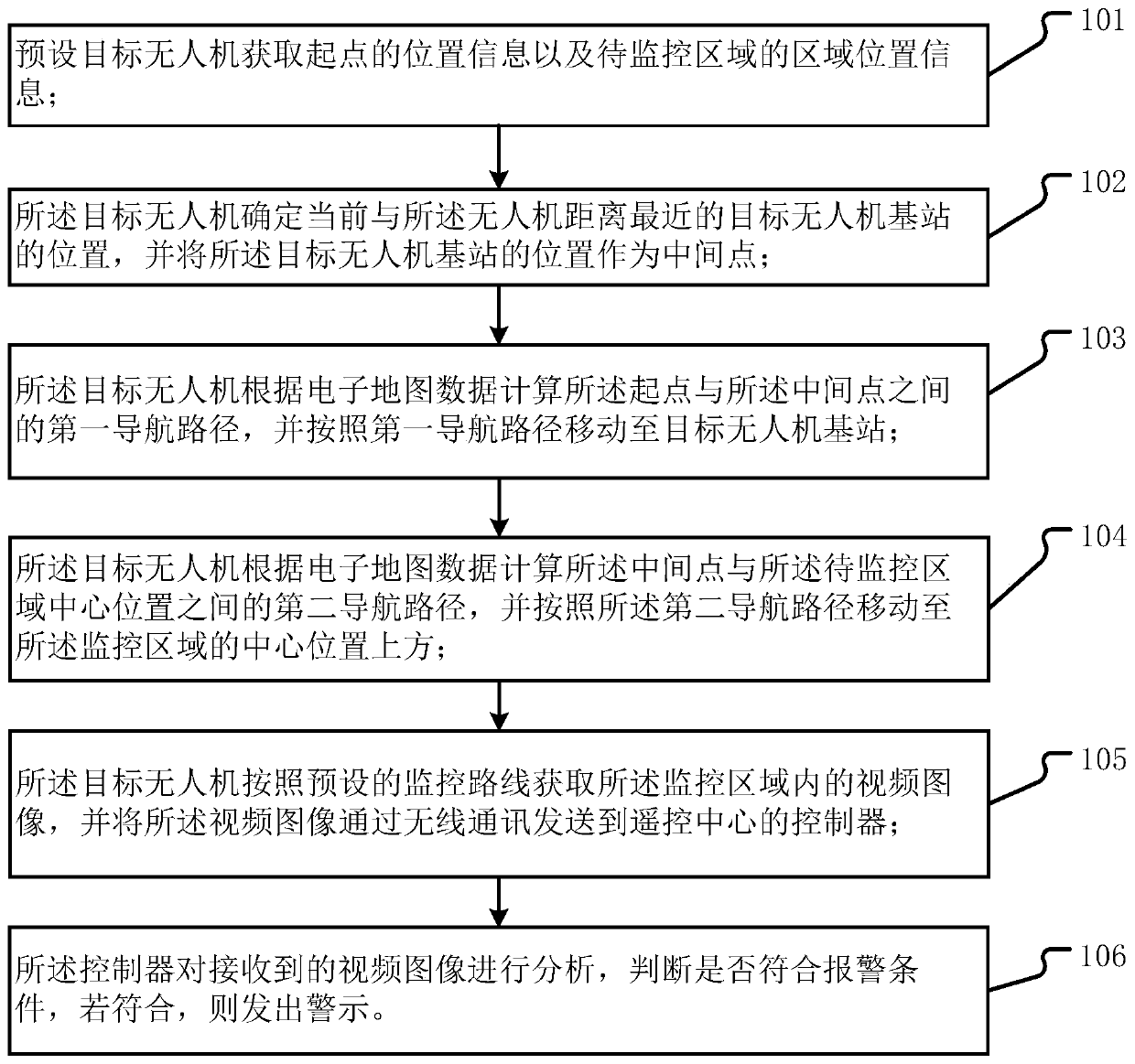
[0053] see figure 1 , a drone-based surveillance method comprising:

[0054] Step 101, the preset target UAV acquires the location information of the starting point and the area location information of the area to be monitored.

[0055]The target unmanned aerial vehicle described in the present invention is an unmanned aerial vehicle for remote monitoring, and monitoring equipment is installed on the unmanned aerial vehicle, such as: a camera and an information transmission device that transmits the video images captured by the camera to the control terminal, and A communication device for establishing a communication connection between the information transmission device and the control terminal. In specific use, in or...


PUM


Abstract

The invention provides a monitoring method based on an unmanned aerial vehicle (UAV). Regional position information of a region to be monitored is acquired, the position of a UAV base station is used as an intermediate point, the UAV calculates a first navigation path between a start point and the intermediate point according to electronic map data, a target UAV calculates a second navigation path between the intermediate point and the central position of the region to be monitored according to the electronic map data, moves to the monitored region according to the first navigation path and the second navigation path to acquire a video image in the monitored region and sends the video image to a controller, and the controller analyzes the received video image and judges whether to give an alarm. By using the UAV base station as an intermediate point, the whole navigation path is split into a plurality of navigation paths for calculation, so that the quantity of calculation every time is reduced; and when the UAV is used for monitoring, the UAV can arrive at the monitored region more quickly, so that the intelligence of the UAV is improved.

Description

technical field [0001] The invention relates to the field of unmanned aerial vehicle monitoring, in particular to a monitoring method based on an unmanned aerial vehicle. Background technique [0002] Despite the continuous development of drone technology, the application of drones in all walks of life is becoming more and more frequent. For example, use drones to spray pesticides on farmland, take pictures at high altitudes, operate drones in sensitive areas, or track drones. [0003] When using UAVs for various operations, it is one of the research directions of researchers in the prior art to make UAVs fly more intelligently and reduce the burden on operators. Some methods of UAV navigation are provided in the prior art. The main idea is: obtain various terrain information according to the existing electronic map data, and then determine a complete navigation path according to the starting point and end point, and set the unmanned The aircraft flies according to the nav...

Claims


Application Information

Patent Timeline
Patent Type & Authority Patents(China)
IPC IPC(8): G05D1/10
CPCG05D1/101
Inventor 邓欢欢
Owner AVIC HUADONG PHOTOELECTRIC SHENZHEN CO LTD
Why Eureka
Try Eureka