Method using multi-scale line element map to make synthetically drawing

A large-scale map and multi-scale technology, applied in the directions of maps/plans/charts, educational equipment, instruments, etc., can solve the problems of missing important elements, less research on multi-scale vector data update, and inaccurate analysis results. Achieve the effect of speeding up analysis, ensuring accuracy, and occupying less storage space

Active Publication Date: 2017-11-21
WUHAN UNIV
View PDF4 Cites 3 Cited by
  • Summary
  • Abstract
  • Description
  • Claims
  • Application Information

AI Technical Summary

Problems solved by technology

[0002] Small-scale maps are usually used for spatial analysis because of their fast calculation speed, but due to the degree of expression at the corresponding scale, some important elements are missing, resulting in inaccurate analysis results. Therefore, it is necessary to synthesize large-scale maps and improve small-scale maps. element integrity
[0003] The key technology for comprehensive cartography using multi-scale line feature maps lies in data matching and data merging. Scholars at home and abroad have done a lot of related research on the matching of multi-scale vector data, but there are few studies on the update of multi-scale vector data.

Method used


Image

  • Method using multi-scale line element map to make synthetically drawing
  • Method using multi-scale line element map to make synthetically drawing
  • Method using multi-scale line element map to make synthetically drawing

Examples


Embodiment

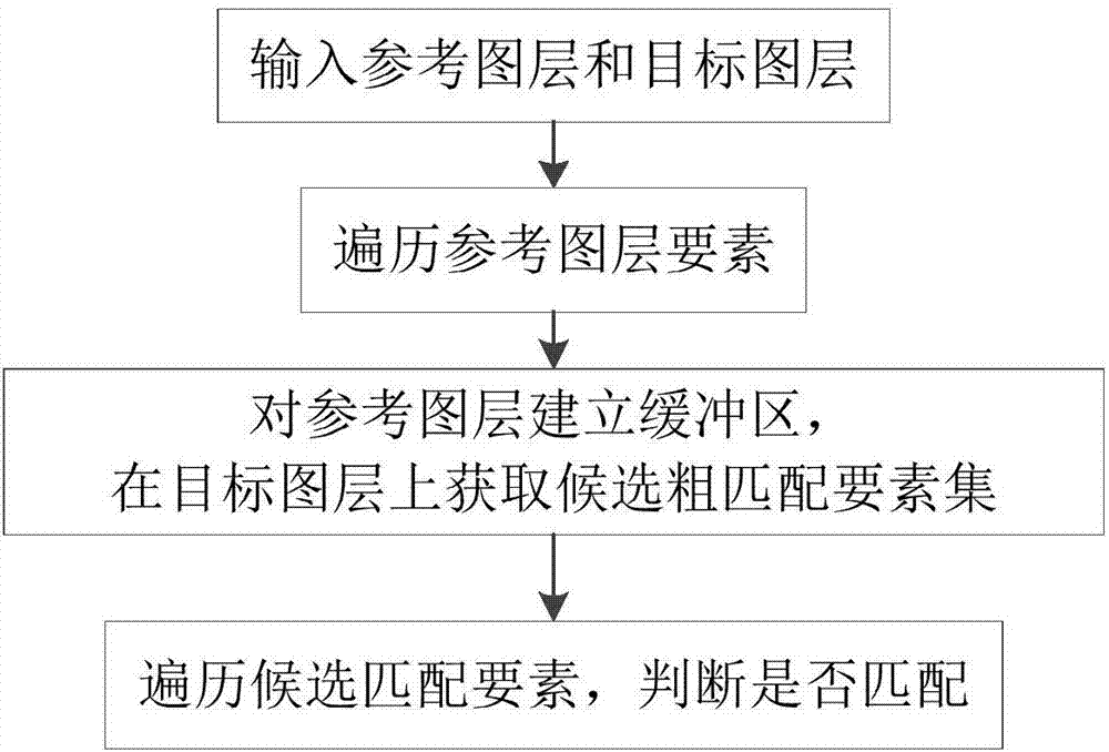
[0039] The process of the embodiment includes the following steps:

[0040] Step 1. Unify the coordinate reference systems of the two original maps, which include a small-scale map and a large-scale map:

[0041] Determine whether the two original maps have a coordinate system;

[0042] If the two original maps have a coordinate system, and the coordinate system is the same, it will not be processed; if the two original maps have a coordinate system, and the coordinate system is different, then transform the coordinate system of any one of the maps so that it is consistent with the other The coordinate systems of the two maps are consistent; if one of the two original maps has a coordinate system and the other does not have a coordinate system, add the same coordinate system to the map without a coordinate system; if neither map has a coordinate system coordinate system, add CGCS_2000 coordinate system for both maps at the same time.

[0043] In this embodiment, the 1:10,000...


PUM


Abstract

The invention discloses a method using a multi-scale line element map to make synthetically drawing; the method comprises the following steps: using an updated large scale map to fast update a non-updated small scale map, wherein the coordinate reference systems of the two original maps are unified, and elements are matched; merging the two maps according to the matching result, keeping the small scale map elements that successfully match with the large scale map, keeping all large scale map elements that cannot match with corresponding elements on the small scale map, simplifying and shortening with equal proportions; finally merging to one map layer, and forming a new map. The new map is complete in elements and small in storage space, and the consistent with the original small scale map in scales; the method can fully utilize updated maps in an existing basic geography information database to fast update and improve non-updated small scale maps, thus parsing spaces, and fast obtaining more accurate analysis results.

Description

technical field [0001] The method of the invention belongs to the field of computer cartography, and in particular relates to comprehensive cartography using line element maps of different scales. Background technique [0002] Small-scale maps are usually used for spatial analysis because of their fast calculation speed, but due to the degree of expression at the corresponding scale, some important elements are missing, resulting in inaccurate analysis results. Therefore, it is necessary to synthesize large-scale maps and improve small-scale maps. element integrity. [0003] The key technology of comprehensive cartography using multi-scale line feature maps lies in data matching and data merging. Scholars at home and abroad have done a lot of related research on multi-scale vector data matching, but there are few studies on multi-scale vector data update. In 2007, Fu Zhongliang et al. proposed a multi-scale spatial database update scheme based on the CHT_EUR spatial databas...

Claims


Application Information

Patent Timeline
IPC IPC(8): G09B29/00
Inventor 孟令奎岳翠莹张文
Owner WUHAN UNIV
Why Eureka
Try Eureka