Eureka AIR delivers breakthrough ideas for toughest innovation challenges, trusted by R&D personnel around the world.

Geostationary orbit optical remote sensing satellite-orientated satellite-ground integrated intelligent control system

An optical remote sensing and intelligent control technology, applied in the field of satellite system design, can solve problems such as high difficulty in control, low efficiency of satellite in-orbit use, complex data processing mode, and complex antenna transmission strategy, so as to achieve rapid task response and convenient task setting Fast and meet the application requirements of different tasks

Active Publication Date: 2017-12-22
BEIJING INST OF SPACECRAFT SYST ENG
View PDF6 Cites 9 Cited by
  • Summary
  • Abstract
  • Description
  • Claims
  • Application Information

AI Technical Summary

Problems solved by technology

However, with the rapid improvement of satellite functions and performance, especially attitude maneuvering capabilities, satellite imaging modes, data processing modes, and antenna transmission strategies are becoming more and more complex. Low performance in orbit

Method used


Image

  • Geostationary orbit optical remote sensing satellite-orientated satellite-ground integrated intelligent control system
  • Geostationary orbit optical remote sensing satellite-orientated satellite-ground integrated intelligent control system
  • Geostationary orbit optical remote sensing satellite-orientated satellite-ground integrated intelligent control system

Examples


Embodiment Construction

[0025] Below in conjunction with accompanying drawing, the present invention is described in further detail:

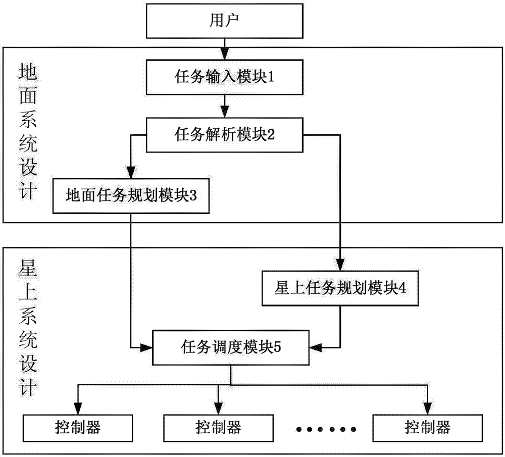
[0026] figure 1 It is a block diagram of the satellite-ground integrated intelligent control system for optical remote sensing satellites in stationary orbit of the present invention. like figure 1 As shown, this satellite-ground integrated intelligent control system for optical remote sensing satellites in stationary orbit includes: task input module 1, task analysis module 2, ground task planning module 3, on-board task planning module 4 and task scheduling module 5; wherein,

[0027] The task input module 1 obtains the task information from the user and inputs it into the task analysis module 2;

[0028] The mission analysis module 2 receives the mission information and performs digital processing to form multiple discrete assignment functions and an instruction block containing only the necessary parameter information of the user's observation mission, and passe...


PUM


Abstract

The invention discloses a geostationary orbit optical remote sensing satellite-orientated satellite-ground integrated intelligent control system. The system comprises a task input module, a task parsing module, a ground task planning module, an on-satellite task planning module and a task scheduling module, wherein the task input module acquires task information from a user and then inputs the task information into the task parsing module, the task parsing module receives the task information and digitizes the task information to generate discrete assignment functions and instruction blocks, the ground task planning module arranges the plurality of discrete assignment functions into a satellite control instruction sequence, the on-satellite task planning module arranges the instruction blocks provided by the ground task parsing module into an imaging task instruction sequence and sends the imaging task instruction sequence to the task scheduling module, and the task scheduling module distributes the satellite control instruction sequence and the imaging task instruction sequence to each controller. With the geostationary orbit optical remote sensing satellite-orientated satellite-ground integrated intelligent control system of the invention adopted, the reliability and earth observation efficiency of a remote sensing satellite during on-orbit work can be improved, and the needs of user imaging tasks can be better satisfied.

Description

technical field [0001] The invention belongs to the field of satellite system design, in particular to a satellite-earth integrated intelligent control system for optical remote sensing satellites in stationary orbit. Background technique [0002] Geostationary orbit (GEO) optical remote sensing satellites can be used as a type of mission-oriented real-time earth observation satellites, with the ability to "reach at any time" for continuous coverage of key military target areas and disaster-prone areas around the world. The "visible anytime" capability of real-time imaging, fast and flexible mission response capability, is very suitable for long-term continuous monitoring and rapid access imaging of the earth. In recent years, with the development of optical imaging payload technology and satellite attitude control technology, the concept of high-resolution optical ground imaging satellites in geosynchronous orbits and the research and engineering development of related tech...

Claims


Application Information

Patent Timeline
IPC IPC(8): G06Q10/06
CPCG06Q10/06312G06Q10/06315G06Q10/06316
Inventor 于登云刘凤晶刘云鹤王丽俐朱玛刘鑫韦涌泉李果杨国巍周永恒
Owner BEIJING INST OF SPACECRAFT SYST ENG
Why Eureka
Eureka Blog
Learn More