Data acquisition method and system for single building modeling based on UAV
A data acquisition system and data acquisition technology, used in control/regulation systems, instruments, surveying and navigation, etc., can solve the problems of low degree of refinement of modeling results and incomplete side texture information.
- Summary
- Abstract
- Description
- Claims
- Application Information
AI Technical Summary
Problems solved by technology
Method used
Image
Examples
Embodiment 1
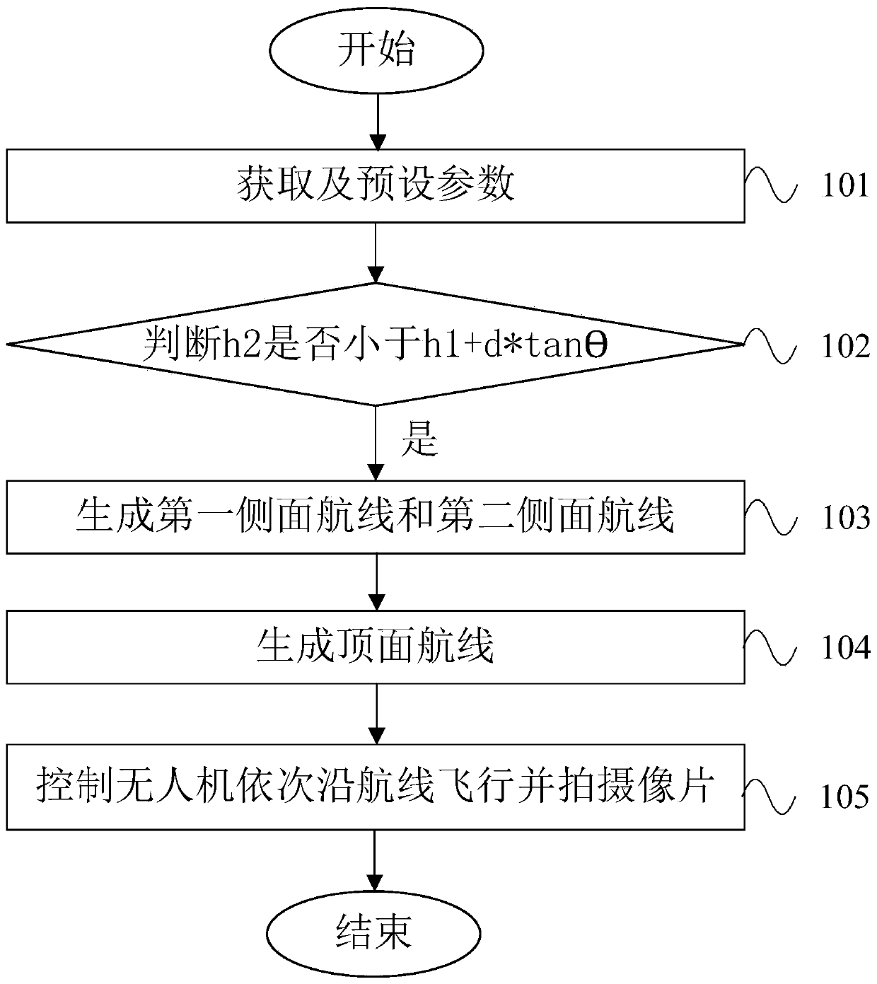
[0108] Such as figure 1 As shown, a UAV-based data acquisition method for single building modeling, the single building includes a top surface, several sides and the joint between surfaces, the UAV carries a camera, and the The data collection method includes the following steps:
[0109] Step 101, obtaining the building height h of the single building 1 , the safe height h of the UAV 2 , the default lateral overlap P 1 and heading overlap P 2 , the initial distance d between the preset camera and the shooting surface, the value of the preset shooting angle θ, fov 1 / 21 Indicates the vertical field of view of the camera;
[0110] Step 102, judge h 2 Is it less than h 1 +d*tanθ, if so, execute step 103;
[0111] Step 103, the height for the side is greater than or equal to the safety height h 2 The part of generates a number of first side routes surrounding the side, the distance between the first side route and the side to be photographed is equal to d, the first side...
Embodiment 2
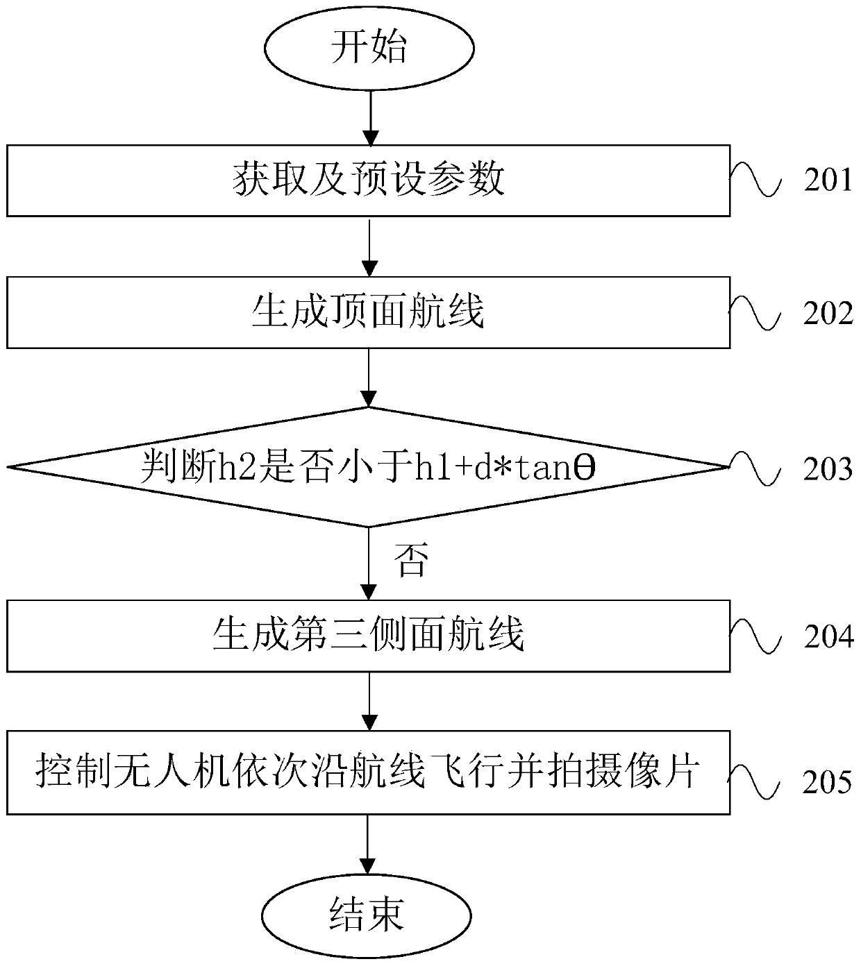
[0128] Such as figure 2 As shown, the difference from Example 1 is that in this example h 2 greater than h 1 +d*tanθ, the data collection method comprises the following steps:
[0129] Step 201, obtain the building height h of the single building 1 , the safe height h of the UAV 2 , the default lateral overlap P 1 , preset heading overlap P 2 , the initial distance d between the preset camera and the shooting surface, the value of the preset shooting angle θ, fov 1 / 21 Indicates the vertical field of view of the camera;
[0130] Step 202, using the route planning method of aerial photogrammetry on the top surface to generate the top surface route;
[0131] Step 203, judge h 2 Is it less than h 1 +d*tanθ, otherwise execute step 204;
[0132] Step 204, generate a number of third side routes around the side, the height of the third side routes is h 2 , the third side routes are distributed at intervals along the horizontal direction, and the third side routes are para...
Embodiment 3
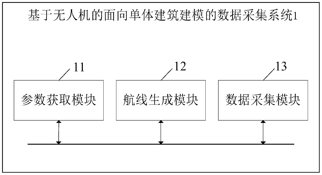
[0142] Such as Figures 3 to 5 As shown, a UAV-based data acquisition system 1 for modeling of a single building, the single building includes a top surface, several sides and the junction between surfaces, the UAV carries a camera, and the The data acquisition system 1 includes a parameter acquisition module 11, a route generation module 12 and a data acquisition module 13; the route generation module 12 includes a judgment module 1201, a top route generation module 1202, a first side route generation module 1203, a second side A route generation module 1204 and a third side route generation module 1205; the data collection module 13 includes a top data collection module 1301 , a first data collection module 1302 and a second data collection module 1303 .
[0143] The parameter acquisition module 11 is used to acquire the building height h of the single building 1 and the safe height h of the UAV 2 , the parameter acquisition module 11 is also used to preset the degree of l...
PUM
 Abstract
Description
Claims
Application Information
 - R&D
- Intellectual Property
- Life Sciences
- Materials
- Tech Scout
- Unparalleled Data Quality
- Higher Quality Content
- 60% Fewer Hallucinations
Browse by: Latest US Patents, China's latest patents, Technical Efficacy Thesaurus, Application Domain, Technology Topic, Popular Technical Reports.
© 2025 PatSnap. All rights reserved.Legal|Privacy policy|Modern Slavery Act Transparency Statement|Sitemap|About US| Contact US: help@patsnap.com


