Automatic geometric correction method for cross-platform lunar-based Earth observation images

An earth observation and geometric correction technology, applied in image enhancement, image analysis, image data processing, etc., can solve the problems of the scarcity of control points, the difficulty of accurate geometric correction of earth observation data, the shift of image center, etc. Integrity and authenticity, addressing hard-to-get and unevenly distributed effects

Active Publication Date: 2020-09-08
INST OF REMOTE SENSING & DIGITAL EARTH CHINESE ACADEMY OF SCI
View PDF9 Cites 0 Cited by
  • Summary
  • Abstract
  • Description
  • Claims
  • Application Information

AI Technical Summary

Problems solved by technology

However, while the moon-based Earth observation achieves instantaneous acquisition of hemispheric images, due to the influence of factors such as the ultra-long distance of 384,000 kilometers, special geometric observation conditions, sublunar point movement, and planetary scale, the observation of the moon-based platform Difficulties in accurate geometric correction of earth observation data are manifested in the problem of geometric deformation differences in different regions of the hemispheric-scale image caused by the curvature of the earth, the shift of the image center caused by the sublunar point, the change of the observed area caused by the movement of the morning and evening line, and the problem of The number of control points is scarce and unevenly distributed due to large-scale oceans, clouds, etc.
[0003] Geometric correction is to establish a mapping relationship between remote sensing image coordinates and corresponding ground point coordinates. Traditional geometric correction methods are suitable for geometric correction of local small areas, often ignoring the influence of the curvature of the earth on geometric distortion. There are limitations in the geometric correction of remote sensing images, so it is very necessary and significant to develop a geometric correction method suitable for lunar-based platforms to Earth observation images in view of the characteristics of lunar-based platforms

Method used


Image

  • Automatic geometric correction method for cross-platform lunar-based Earth observation images
  • Automatic geometric correction method for cross-platform lunar-based Earth observation images
  • Automatic geometric correction method for cross-platform lunar-based Earth observation images

Examples


Embodiment Construction

[0040] In order to make the objectives, technical solutions and advantages of the present invention clearer, the technical solutions in the embodiments of the present invention will be clearly and completely described below with reference to the accompanying drawings in the embodiments of the present invention. It should be understood that the specific The embodiments are only used to explain the present invention, and are not intended to limit the present invention. The described embodiments are only some, but not all, embodiments of the present invention. Based on the embodiments of the present invention, all other embodiments obtained by those of ordinary skill in the art without creative efforts shall fall within the protection scope of the present invention.

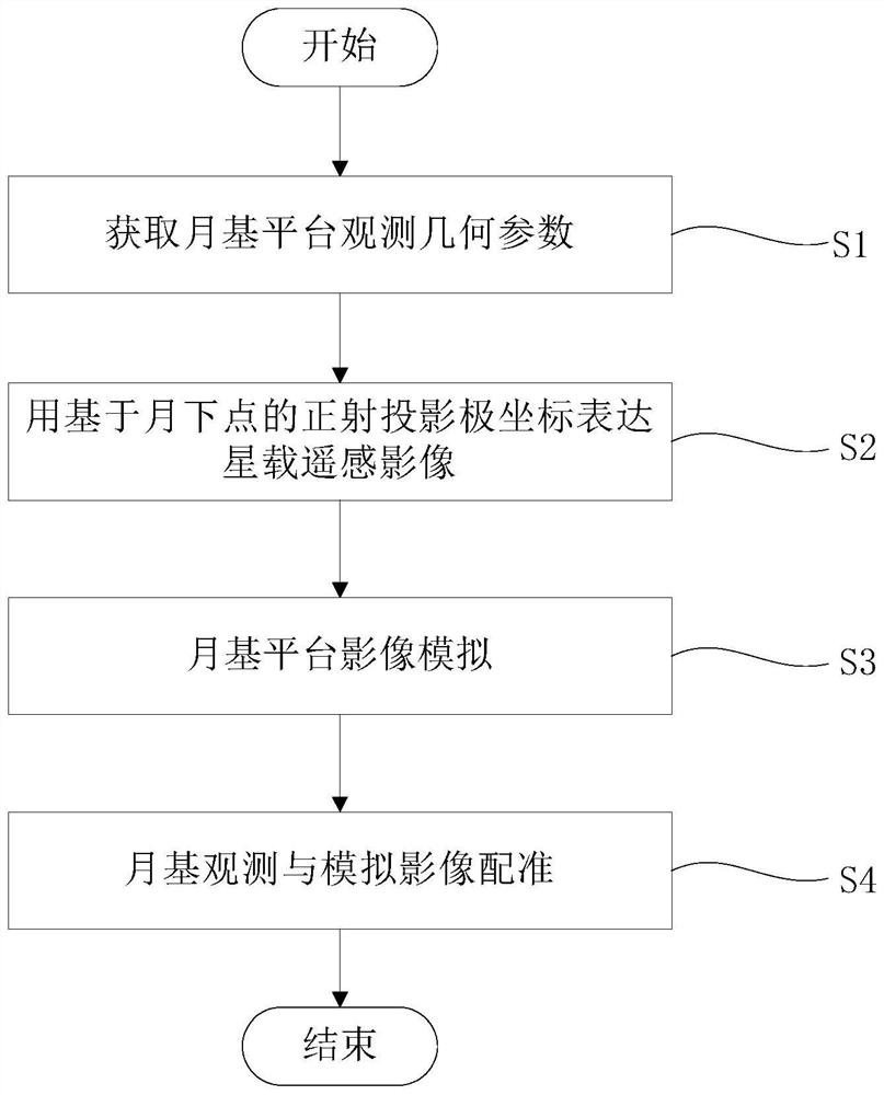
[0041] figure 1 A flow chart of the cross-platform moon-based Earth observation image automatic geometric correction method of the present invention is shown in . like figure 1 As shown, the cross-platform moon-b...


PUM


Abstract

The invention systematically analyzes influence factors of the moon-earth relationship and the lunar-based remote sensing data geometric distortion, focuses on the large-scale hemispherical image geometric distortion caused by the curvature and the elevation fluctuation of the earth, the problem of few and uneven distribution of ground control points and the like, and realizes geometric correctionof the lunar-based platform earth observation data by taking the advantages of multi-platform earth observation data collaboration and lunar-based projection polar coordinate expression.

Description

technical field [0001] The invention relates to the field of earth observation, in particular to a method for automatic geometric correction of cross-platform moon-based earth observation images, in particular to an automatic geometric correction of cross-platform moon-based earth observation images based on sublunar point projection polar coordinate expression method. Background technique [0002] In order to realize the monitoring of macroscopic phenomena at the planetary scale and in a long-term continuous sequence, the research team led by Academician Guo Huadong proposed a new idea of ​​the moon-based platform for Earth observation. The moon is the only natural satellite of the earth. It has the characteristics of integrity and stability in observing the earth, and provides a more ideal observation platform for studying the macroscopic scientific phenomena of the earth. However, while the moon-based earth observation achieves the instantaneous acquisition of hemispheri...

Claims


Application Information

Patent Timeline
Patent Type & Authority Patents(China)
IPC IPC(8): G06T5/00G06T7/33
CPCG06T5/006G06T7/33G06T2207/10032
Inventor 郭华东张露焦慧刘广
Owner INST OF REMOTE SENSING & DIGITAL EARTH CHINESE ACADEMY OF SCI
Why Eureka
Try Eureka