Compensation elevation plane or mean elevation plane-based 3-degree zoning coordinate conversion system

A technology of average elevation and coordinate transformation, applied in the field of surveying and mapping science, can solve problems such as unsatisfactory requirements

Inactive Publication Date: 2018-04-13
SHANDONG JIAOTONG UNIV
View PDF5 Cites 9 Cited by
  • Summary
  • Abstract
  • Description
  • Claims
  • Application Information

AI Technical Summary

Problems solved by technology

According to the geographical location and average elevation of the project or city, the standard 3° z

Method used


Image

  • Compensation elevation plane or mean elevation plane-based 3-degree zoning coordinate conversion system
  • Compensation elevation plane or mean elevation plane-based 3-degree zoning coordinate conversion system
  • Compensation elevation plane or mean elevation plane-based 3-degree zoning coordinate conversion system

Examples


Embodiment Construction

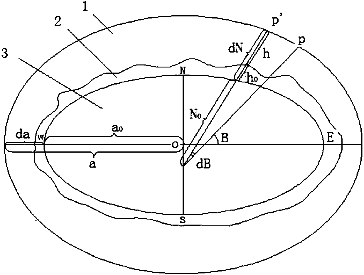
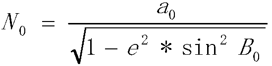
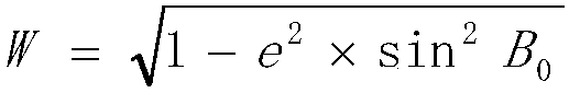
[0031]In order to make the purpose, technical solutions and advantages of the embodiments of the present invention clearer, the technical solutions in the embodiments of the present invention will be clearly and completely described below in conjunction with the drawings in the embodiments of the present invention. Obviously, the described embodiments It is a part of embodiments of the present invention, but not all embodiments. The components of the embodiments of the invention generally described and illustrated in the figures herein may be arranged and designed in a variety of different configurations. Accordingly, the following detailed description of the embodiments of the invention provided in the accompanying drawings is not intended to limit the scope of the claimed invention, but merely represents selected embodiments of the invention. Based on the embodiments of the present invention, all other embodiments obtained by persons of ordinary skill in the art without maki...


PUM


Abstract

The invention discloses a compensation elevation plane or mean elevation plane-based 3-degree zoning coordinate conversion system. By research on a geodetic coordinate change law of a control point ona reference ellipsoid, a compensation elevation plane or a testing zone and a mean elevation plane of a city, a calculation method for a semi-major axis of a new ellipsoid after adoption of the compensation elevation plane or the testing zone and the mean elevation plane of the city, a calculation method for a geodetic latitude correction number and new geodetic latitude of the ground control point, and a calculation method for calculating direct and inverse computation parameters by taking the compensation elevation plane or the testing zone, the mean elevation plane of the city, the semi-major axis of the ellipsoid and first eccentricity as arguments are derived. Compared with the prior art, the control point is transferred to the compensation elevation plane or the testing zone and themean elevation plane of the city from the CGCS2000 ellipsoid according to calculation formulae for the direct and inverse computation parameters; high-precision coordinate conversion of geodetic coordinates and plane coordinates can be realized; and a conversion mode is also suitable for a 1980 Xi an coordinate system, a 1954 Beijing coordinate system and local independent coordinate systems.

Description

technical field [0001] The invention relates to the field of surveying and mapping science and technology, in particular to a 3° zonal coordinate transformation system based on a compensated elevation surface or an average elevation surface. Background technique [0002] CGCS2000 is my country's current "2000 National Geodetic Coordinate System", which belongs to the three-dimensional geocentric coordinate system. However, in the fields of engineering construction and urban construction, the elevation still adopts the normal height system, and the coordinates still need to be Gauss-Krüger conformal projection. Complete the control survey, topographic map surveying and construction stakeout work on the plane. [0003] The national and industry standards have regulations on the plane coordinate system: it is required that the deformation value of the ground observation side length is not greater than 2.5cm / km, and the deformation value includes the elevation normalization from ...

Claims


Application Information

Patent Timeline
IPC IPC(8): G06F17/50
CPCG06F30/13G06F30/20
Inventor 王德保何必王茜
Owner SHANDONG JIAOTONG UNIV
Why Eureka
Try Eureka