Engineering investigation data management and assessment GIS

A data management and engineering survey technology, applied in data processing applications, electrical digital data processing, special data processing applications, etc. problems and achieve significant social and economic benefits

Inactive Publication Date: 2018-04-13
STATE GRID SICHUAN ECONOMIC RES INST +3
View PDF9 Cites 6 Cited by
  • Summary
  • Abstract
  • Description
  • Claims
  • Application Information

AI Technical Summary

Problems solved by technology

[0002] Traditional engineering survey data are scattered in various survey and design units, and the survey results are only used for a specific project. After the project is completed and accepted, the survey results are mostly sealed in the form of reports, forms and drawings, which are difficult to be reused.
The fact that the survey results are scattered and messy under the current conditions prevents the existing survey results from being scientifically managed and utilized

Method used


Image

  • Engineering investigation data management and assessment GIS
  • Engineering investigation data management and assessment GIS
  • Engineering investigation data management and assessment GIS

Examples


Embodiment Construction

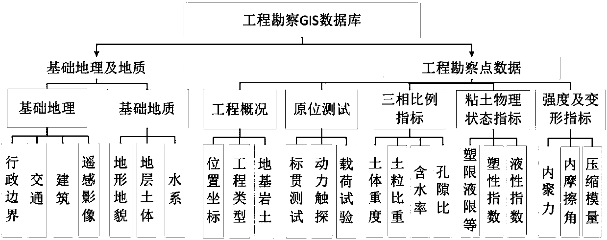
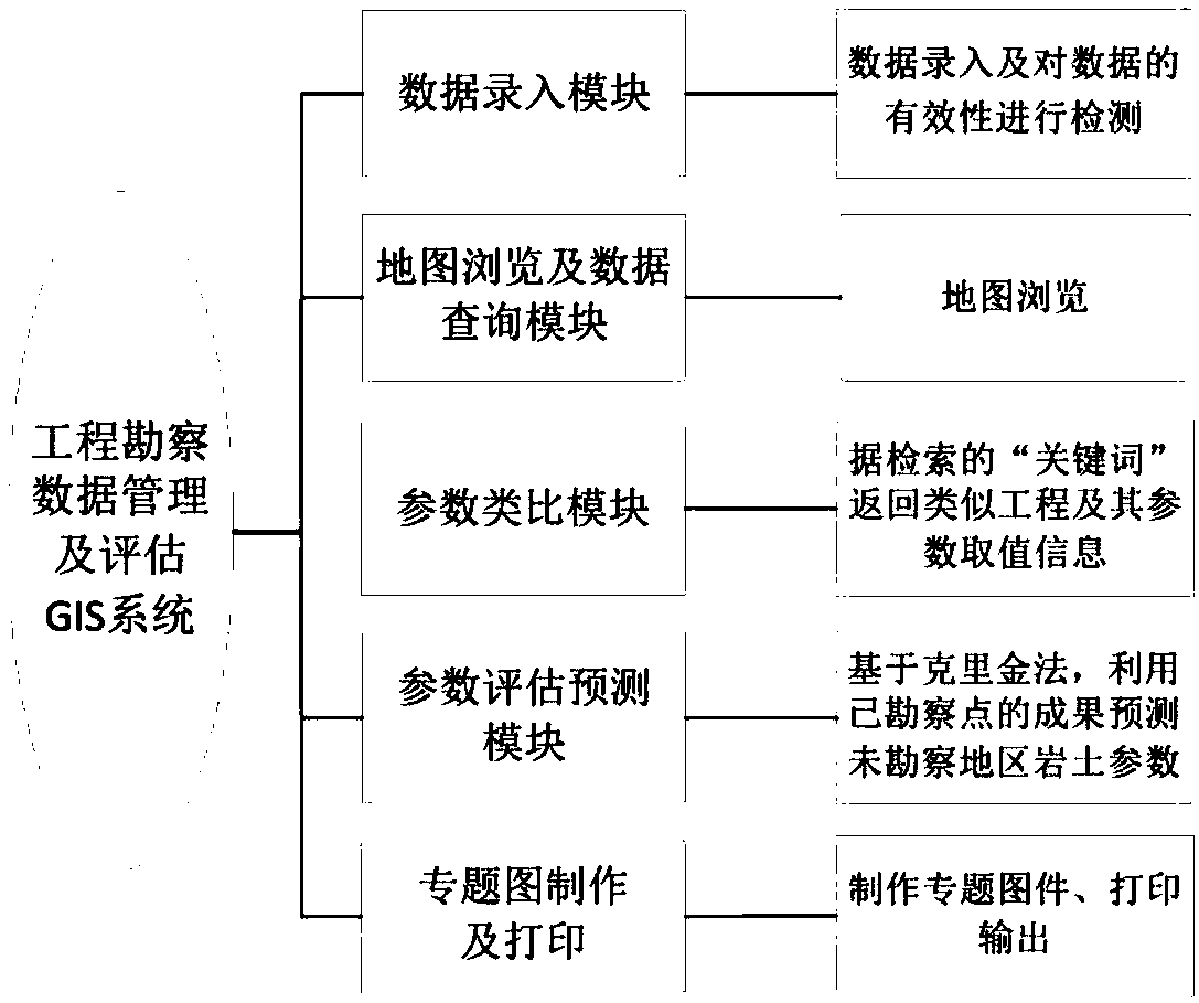
[0029] The invention provides a GIS system for engineering survey data management and evaluation, which solves the defects of scattered and messy survey results under the current conditions, realizes the integrated management and application of engineering survey results, and fully taps the potential of existing survey results It provides an important reference basis for urban planning, survey and construction, and has a technical effect of significant social and economic benefits.

[0030] In order to understand the above-mentioned purpose, features and advantages of the present invention more clearly, the present invention will be further described in detail below in conjunction with the accompanying drawings and specific embodiments. It should be noted that, under the condition of not conflicting with each other, the embodiments of the present application and the features in the embodiments can be combined with each other.

[0031] In the following description, many specifi...


PUM


Abstract

The invention discloses an engineering investigation data management and assessment GIS. The system comprises a collection unit used for collecting existing foundation geotechnical engineering investigation data of a region, and an establishment unit used for establishing a database based on the data collected by the collection unit. The engineering investigation data management and assessment GISis used for, based on the data of the database, performing management and query on the data and performing analogy and prediction on foundation geotechnical parameters; integrated management and application of city engineering investigation results are realized; potential values of existing investigation results are fully mined; important reference bases are provided for city planning, investigation and construction; and the system has the technical effect of remarkable social and economic benefits.

Description

technical field [0001] The invention relates to the field of geotechnical engineering survey, in particular to an engineering survey data management and evaluation GIS system. Background technique [0002] Traditional engineering survey data are scattered in various survey and design units, and the survey results are only used for a specific engineering project. After the project is completed and accepted, the survey results are mostly sealed in the form of reports, forms and drawings, which are difficult to be reused. . The fact that the survey results are scattered and messy under the current conditions makes it difficult for the existing survey results to be managed and used scientifically. Contents of the invention [0003] The invention provides a GIS system for engineering survey data management and evaluation, which solves the defects of scattered and messy survey results under the current conditions, realizes the integrated management and application of engineerin...

Claims


Application Information

Patent Timeline
Patent Type & Authority Applications(China)
IPC IPC(8): G06Q10/06G06Q50/26G06F17/30
CPCG06Q10/063G06Q50/26G06F16/29
Inventor 范荣全李源亮肖红张玉鸿张正勇李惠民王文广任光明王滨张烨黄建平谢伟李根富李小涛胡勇
Owner STATE GRID SICHUAN ECONOMIC RES INST
Why Eureka
Try Eureka