A method of improving inertial navigation performance by using cloud-based road matching

A road and cloud technology, applied in the field of navigation and positioning, can solve problems such as unavailability, data traffic affecting performance, and inability to store a large amount of map data, to achieve the effect of balancing storage space and traffic, improving inertial navigation performance, and balancing the impact of constraints

Active Publication Date: 2021-02-19
QIANXUN SPATIAL INTELLIGENCE INC
View PDF10 Cites 0 Cited by
  • Summary
  • Abstract
  • Description
  • Claims
  • Application Information

AI Technical Summary

Problems solved by technology

However, the VDR calculation accuracy error will continue to diverge over time until it becomes unusable
[0003] In the existing technical solution, the storage space on the device side is limited, and it cannot store a large amount of map data. In some areas, the road matching process cannot be carried out effectively. If you simply request the server to get the road matching result, the data traffic on the device will be consumed and it will be in the network. Affects performance in bad cases, and the road matching result is not used as a decision factor in the VDR calculation to affect the calculation initialization process

Method used


Image

  • A method of improving inertial navigation performance by using cloud-based road matching
  • A method of improving inertial navigation performance by using cloud-based road matching
  • A method of improving inertial navigation performance by using cloud-based road matching

Examples


Embodiment Construction

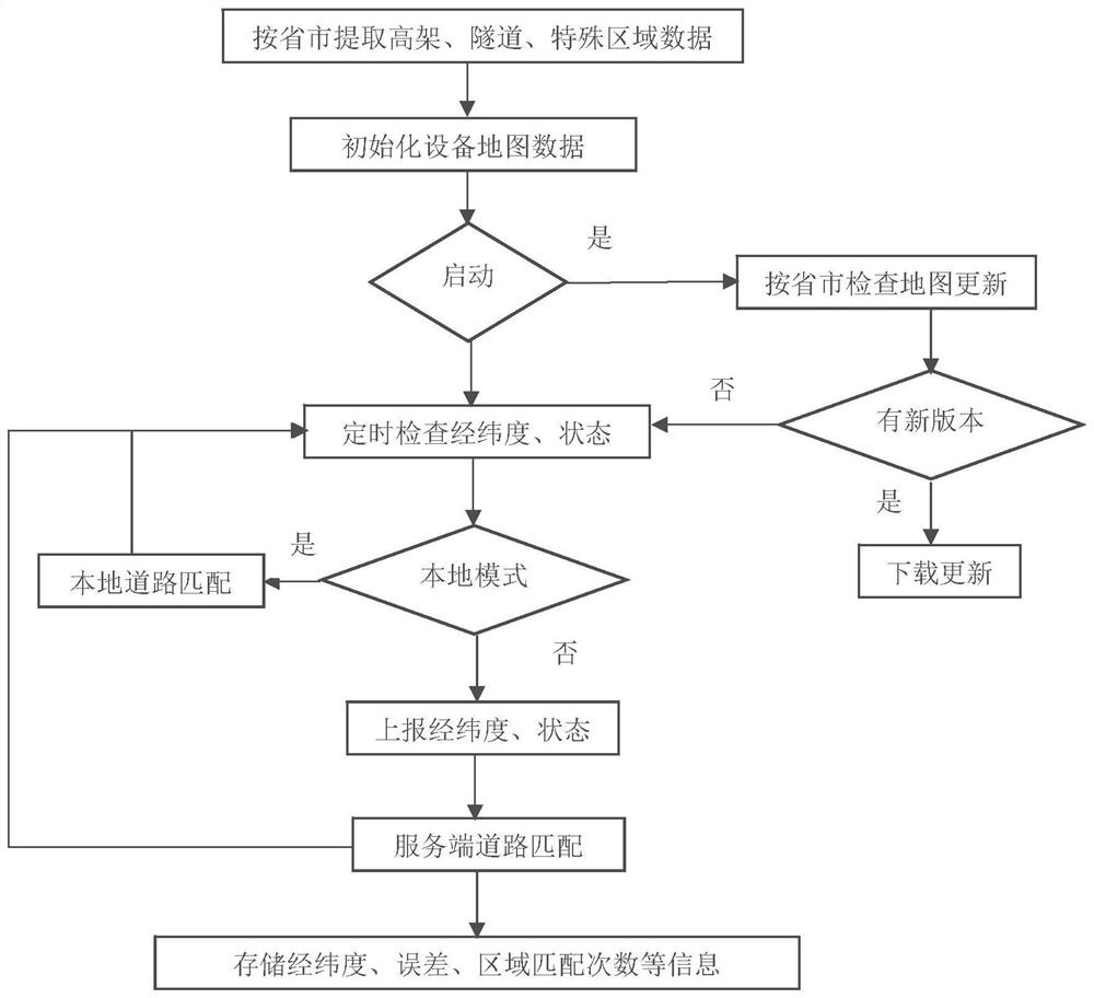
[0030] The present invention provides a method for improving inertial navigation performance by using cloud-combined road matching, that is, adopting a road matching mode combining cloud (server) and terminal (device) to reduce the problem of large space occupied by map data loading on the terminal , and at the same time use the server-side data to help the device side decide whether to re-initialize the calculation process during the VDR calculation process, thereby improving the VDR performance. Hereinafter, the present invention will be further described in conjunction with the drawings and embodiments.

[0031] figure 1 It is a flow chart of road matching mode combining cloud and terminal in the present invention, including the following steps:

[0032] Step 1. Extract map data of tunnels, viaducts, and special areas by province and city:

[0033] VDR is mainly judged when GPS positioning accuracy is poor (according to the indicators that come with GPS positioning, such ...


PUM


Abstract

The invention provides a method for improving inertial navigation performance by utilizing cloud and terminal combined road matching. The method comprises the following steps: step 1, extracting map data of a region with relatively poor GPS (Global Positioning System) positioning precision; step 2, initializing the map data of an equipment terminal; step 3, judging a local mode; step 4, carrying out road matching by a server side. The method provided by the invention adopts a cloud and terminal combined road matching mode so that the problem that the loading occupied space of the map data on the terminal is relatively large is solved; meanwhile, the data of the server side is used for helping the equipment terminal to determine whether a reckoning process needs to be initialized again or not in a VDR (Voyage Data Recorder) reckoning process, so that the VDR performance is improved.

Description

technical field [0001] The invention relates to the technical field of navigation and positioning, in particular to a method for improving inertial navigation performance by using cloud-combined road matching. Background technique [0002] GPS (Global Positioning System, Global Positioning System) positioning accuracy is closely related to the environment. In a complex urban environment, due to unavoidable factors such as occlusion and multipath effects, the GPS positioning accuracy often reaches 10-20m or more. VDR (Vehicle Dead Reckoning, Vehicle Dead Reckoning) does dead reckoning, which can repair GPS positioning deviation within a certain distance; using road matching (Map Matching, the process of matching the longitude and latitude sampling sequence of the driving track with the digital map road network) can also The GPS positioning point can be corrected to the latitude and longitude point where the road is located in the driving state. However, the VDR calculation a...

Claims


Application Information

Patent Timeline
Patent Type & Authority Patents(China)
IPC IPC(8): G01C21/32G01C25/00
CPCG01C21/32G01C25/005
Inventor 丁源熊
Owner QIANXUN SPATIAL INTELLIGENCE INC
Why Eureka
Try Eureka