
A method for discriminating multi-path areas in a vehicle positioning system

A vehicle-mounted positioning system and multi-path technology, applied in the field of multi-path area discrimination in the vehicle-mounted positioning system, can solve problems such as difficult to judge, only reach 10-20m or even worse, and the estimation accuracy error will continue to diverge over time. To achieve the effect of improving the positioning experience

Active Publication Date: 2018-12-28
QIANXUN SPATIAL INTELLIGENCE INC
View PDF5 Cites 0 Cited by
  • Summary
  • Abstract
  • Description
  • Claims
  • Application Information

AI Technical Summary

Problems solved by technology

[0003] The positioning accuracy of GPS (Global Positioning System, Global Positioning System) is closely related to the environment. In open conditions, the positioning accuracy of civilian GPS can reach 3-5 meters. Existence, GPS positioning accuracy often can only reach 10-20m or worse, and when the GPS signal is poor, use VDR (Vehicle Dead Reckoning, vehicle dead reckoning) to do dead reckoning, which can repair GPS positioning deviation within a certain distance. However, the VDR calculation accuracy error will continue to diverge over time until it becomes unusable. Therefore, in the urban environment, vehicle positioning technology needs GPS and inertial navigation and other technical means to cooperate. However, multi-path judgment is difficult to do accurately under the existing GPS positioning technology. make judgments and propose solutions

Method used


Image

  • A method for discriminating multi-path areas in a vehicle positioning system

Examples


Embodiment Construction

[0023] The present invention will be further described below in conjunction with the accompanying drawings and specific embodiments. The embodiments of the present invention are only used to illustrate the technical solutions of the present invention rather than limit the protection scope of the present invention.

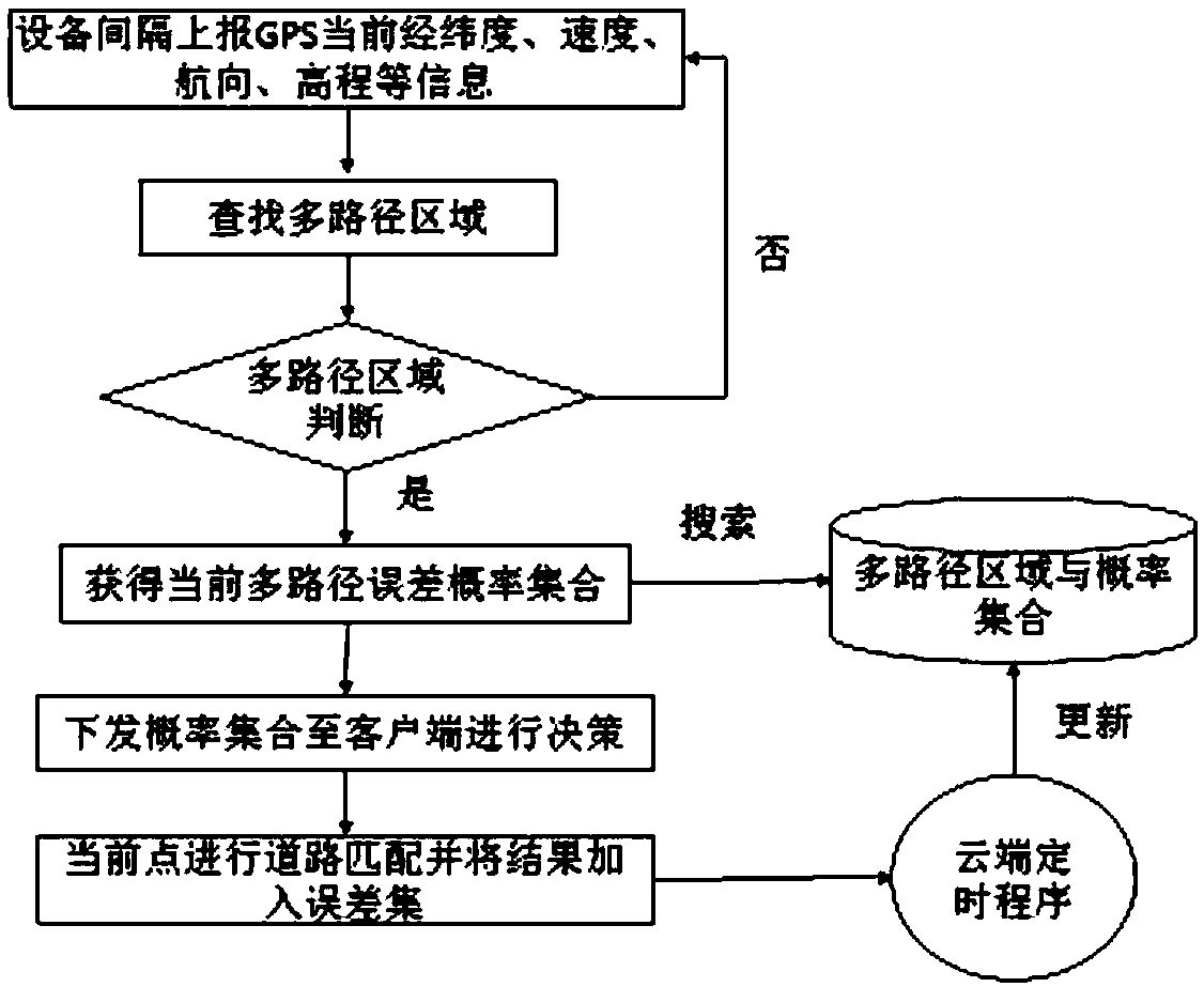
[0024] Such as figure 1 As shown, the present invention proposes a method for discriminating multi-path areas in a vehicle positioning system, comprising the following steps:

[0025] S1: The vehicle obtains NMEA information from the GPS positioning device (positioning chip) regularly (every few seconds to more than ten seconds), analyzes the NMEA information to obtain current latitude and longitude, speed, heading, elevation and other information and uploads it to the server through the client;

[0026] S2: The server searches for a multi-path area, and judges whether the current point is a multi-path area, if the judgment result is otherwise, return to step S1; ...


PUM


Abstract

The invention relates to a method for distinguishing a multipath region in a vehicle-mounted positioning system. The method includes the following steps: a vehicle obtains NMEA information from a GPS positioning device regularly, and uploads the NMEA information to a server through a client; the server looks for a multipath region, and judges whether a current point is in a multipath region; the server searches for an existing multipath region and probability set, and obtains a current multipath error probability set; the server issues the multipath error probability set to the client; and the client performs road matching on the current point. Cloud map matching and data mining technologies are utilized, multipath regions are identified according to the probability of occurrence of a multipath effect and indexed, at the same time, the vehicle performs integration to realize positioning of the client, rapid decision of a positioning mode and positioning result output of the vehicle are assisted, and positioning experience is improved.

Description

technical field [0001] The invention relates to a positioning method of a vehicle positioning system, in particular to a method for discriminating multi-path areas in the vehicle positioning system. Background technique [0002] The multipath effect refers to that after the electromagnetic wave propagates through different paths, each component field arrives at the receiving end at different times, and superimposed on each other according to their respective phases to cause interference, distorting the original signal, or generating errors. [0003] The positioning accuracy of GPS (Global Positioning System, Global Positioning System) is closely related to the environment. In open conditions, the positioning accuracy of civilian GPS can reach 3-5 meters. Existence, GPS positioning accuracy often can only reach 10-20m or worse, and when the GPS signal is poor, use VDR (Vehicle Dead Reckoning, vehicle dead reckoning) to do dead reckoning, which can repair GPS positioning devia...

Claims


Application Information

Patent Timeline
Patent Type & Authority Patents(China)
IPC IPC(8): G01S19/22
CPCG01S19/22
Inventor 丁源熊
Owner QIANXUN SPATIAL INTELLIGENCE INC
Learn More