Geological drilling spatial trajectory restoration method

A trajectory and space technology, applied in special data processing applications, instruments, electrical and digital data processing, etc., can solve the problems of affecting the modeling effect, unable to correctly obtain the stratum position and the location of the ore, and achieve the effect of convenient operation.

Active Publication Date: 2018-07-06
BEIJING RES INST OF URANIUM GEOLOGY
View PDF4 Cites 3 Cited by
  • Summary
  • Abstract
  • Description
  • Claims
  • Application Information

AI Technical Summary

Problems solved by technology

However, before the 1990s, most of the exploration work did not keep the original inclinometer records, and it was impossible to correctly obtain the stratum position and ore encounter position, which affected the modeling effect

Method used


Image

  • Geological drilling spatial trajectory restoration method
  • Geological drilling spatial trajectory restoration method

Examples


Embodiment 1

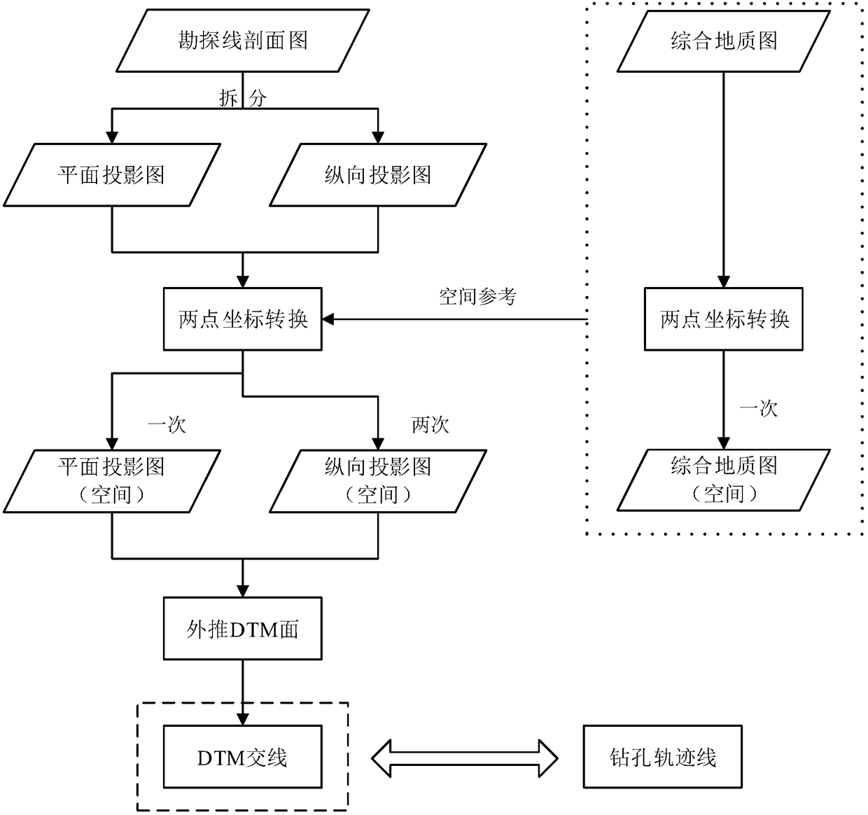
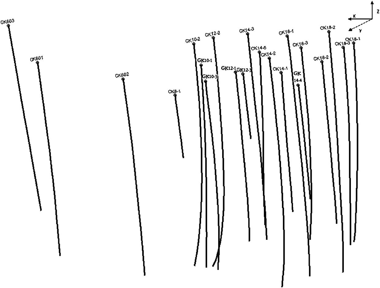
[0043] Taking the Chuankeng ore deposit of Xiangshan Orefield as an example, the method for restoring the spatial trajectory of geological drilling in this embodiment includes the following steps:

[0044] Step S1: 3D conversion of integrated geological map

[0045] Select two grid diagonal points in the comprehensive geological map of Chuankeng ore deposit in Xiangshan Minefield, that is, the scope of the work area, according to the displayed coordinates (90400, 48800), (90400, 48800) and the corresponding real coordinates (390400, 3048800) ), (391600, 3050800), determine the parameters and convert.

[0046] Step S2: Spatial positioning of the prospecting line profile

[0047] Taking the sectional view of the No. 47 exploration line of the Chuankeng ore deposit as an example, the operations of step S21 and step S22 are performed.

[0048] Step S21: Use two-point coordinate transformation to perform three-dimensional transformation on the plane projection map of the explorat...


PUM


Abstract

The invention belongs to the technical field of uranium ore geology research and uranium resource region evaluation, and particularly relates to a geological drilling spatial trajectory restoration method. The method comprises the following steps of performing three-dimensional conversion of a generalized geological map; performing spatial locating of a prospecting line profile map, performing three-dimensional conversion on a prospecting line planar projection map by utilizing two-point coordinate conversion to obtain a converted prospecting line planar projection map, and performing three-dimensional conversion on a prospecting line longitudinal projection map by utilizing the two-point coordinate conversion to obtain a converted prospecting line longitudinal projection map; and restoring a drilling trajectory. According to the method, a spatial form of drilling can be obtained; a stratigraphical position and an ore discovery position can be accurately obtained; and exploration engineering deployment can be restored to the maximum extent.

Description

technical field [0001] The invention belongs to the technical field of uranium ore geological research and regional evaluation of uranium resources, and in particular relates to a method for restoring geological drilling space trajectory. Background technique [0002] Since the 1990s, 3D geological modeling has received extensive attention. Compared with traditional information display methods, 3D visualization results are more intuitive, flexible, and receptive, and are conducive to discovering information that was difficult to obtain by relying on 2D visualization results in the past. [0003] The stratum position and ore-seeing position revealed by drilling are important data supports for 3D geological modeling. However, before the 1990s, most of the exploration work did not retain the original inclinometer records, and it was impossible to correctly obtain the stratum position and ore encounter position, which affected the modeling effect. [0004] Extracting the boreho...

Claims


Application Information

Patent Timeline
Patent Type & Authority Applications(China)
IPC IPC(8): G06F17/50
CPCG06F30/20
Inventor 朱鹏飞张文明何紫兰孔维豪曹珂白芸马恒
Owner BEIJING RES INST OF URANIUM GEOLOGY
Why Eureka
Try Eureka