Real-time traffic risk AI prediction method and system based on driving path

A technology of driving path and prediction method, which is applied to the traffic control system of road vehicles, traffic control system, traffic flow detection, etc.

Active Publication Date: 2021-06-18
TERRA DIGITAL CREATING SCI & TECH (BEIJING) CO LTD
View PDF12 Cites 0 Cited by
  • Summary
  • Abstract
  • Description
  • Claims
  • Application Information

AI Technical Summary

Problems solved by technology

[0003] For road safety issues, the existing technology does not consider the risk of traffic accidents caused by the intersection or overlap of driving paths
And mainly focus on road path planning (CN104567898A, CN101776458A), road congestion (CN108198449A, CN102636177A), or safety control (CN110021185A), it is to passively consider how to choose the optimal path form or how to avoid risks under the state of existing road facilities, Failure to consider the nature of traffic accidents in principle and the construction of urban motor vehicle roads derived from traffic accidents (such as whether the design of road specifications, layout, and ground line divisions are reasonable), local weather, and driver driving information (including driving habits) and route records) and other factors

Method used


Image

  • Real-time traffic risk AI prediction method and system based on driving path
  • Real-time traffic risk AI prediction method and system based on driving path
  • Real-time traffic risk AI prediction method and system based on driving path

Examples


Embodiment 1

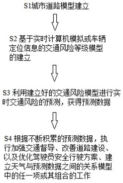
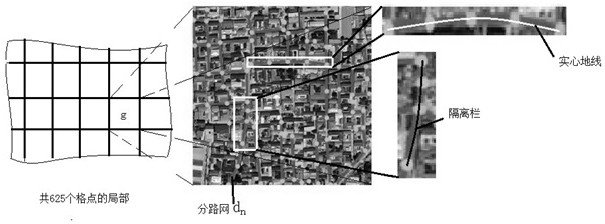
[0067] Such as figure 1 As shown, the real-time traffic risk AI prediction method based on driving path of the present invention includes S1 urban road model establishment of artificial intelligence model to identify urban roads and form a gridded urban road network C , the urban road network C Mesh to form 625 branch networks d 1 , d 2 ,..., d 625(see figure 2 ).

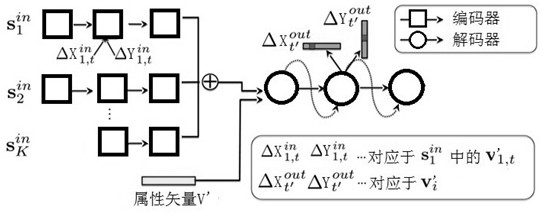
[0068] The artificial intelligence model includes: using the RNN cyclic neural network algorithm to generate road continuous nodes through an encoder and a decoder, and connecting the two nodes before and after generation during the generation process, and inputting new generation nodes into the node generator to continuously generate new nodes, and continue to connect the generated new nodes, so that the loop is connected to form a road network.

[0069] Specifically, the road network extraction process includes: gridding the city, for each grid point g Carry out branch network extraction, each grid poi...

Embodiment 2

[0079] Described step S2 specifically comprises as follows:

[0080] S2-1 Obtain the rush hour for going to work Figure 4 Mid-city road network C a grid of g One of the vehicles in the partial road network with construction points in m i driving route information,

[0081] Wherein, the driving route information includes: currently set driving route, historical route, information of deviation from the route, grid points g The number of vehicles on the same road within the current radius range R=150m is 3, and the number of vehicles on the overlapping road route within the radius range of 150m is 3; no vehicle deviation from the path is found in this embodiment.

[0082] S2-2 The server obtains the currently set driving route planned by the navigation device, then sends the known route information and driving route information to the prediction terminal, and calculates the m i Two of the vehicles on the same road route within a radius of 150m have the currently set trave...

Embodiment 3

[0085] When S2-3 acquires the remaining vehicle whose current driving path is unknown due to the navigation not being turned on n i with the car m i Road alignments have the same road and coincide with historical paths on the same road alignment l k , are also within 150m, and are already at the coincidence, the distance variation is getting smaller and 80m apart. and there is a history path l k is the vehicle's driving path calculated according to the positioning system in the vehicle, and the server records the vehicle's n i Two regular historical routes exist throughout the year l 1 with l 2 , and go from Monday to Friday l 1 while the weekend go l 2 , while traveling the same unconventional driving path only 10 times a year s 1 , then it is considered that the probability of 10 / 365=2 / 73 in a year is to go s 1 And 71 / 73 probability to go l 1 with l 2 . Among them, the probability of 5 / 7×71 / 73 goes l 1 And 2 / 7×71 / 73 probability to go l 2 ,but =5 / ...


PUM


Abstract

Therefore, the real-time traffic risk AI prediction method and system based on the driving path provided by the invention are characterized in that the method comprises the following steps: S1, establishing an urban road model; s2, establishing a traffic risk level model based on real-time computer simulation or vehicle positioning information; s3, performing real-time traffic risk prediction by using the established traffic risk model to obtain prediction data; or the method comprises the steps of S1 to S3, and further comprises the steps: and S4, according to the continuously accumulated prediction data, executing any one or a combination of the work of enhancing traffic supervision, improving road construction, optimizing a safe driving scheme of a driver and establishing a relation model between weather and the prediction data. According to the invention, real-time monitoring of urban road risks is realized, and big data support is provided for traffic construction, current and historical driving records of search vehicles and local weather conditions.

Description

technical field [0001] The invention relates to a road traffic risk and road condition analysis system, in particular to a real-time traffic risk AI prediction system based on driving path, which belongs to the field of road traffic control. Background technique [0002] The development stage of a smart city is divided into six levels. The first is to establish a visual foundation, that is, digitalization of urban geography; the second is to design models based on digitalization; the third is to diagnose cities; and the fourth is to predict cities. Among many prediction projects, the comprehensive analysis and prediction of urban road traffic accident risk and road conditions based on the realization of urban geography digitization is one of the important development plans of smart cities. The root cause of road traffic accidents is the existence of vehicles, especially motor vehicles. Therefore, the monitoring of driving between motor vehicles is the primary issue of smart ...

Claims


Application Information

Patent Timeline
Patent Type & Authority Applications(China)
IPC IPC(8): G08G1/01
CPCG08G1/0104G08G1/0129
Inventor 刘俊伟
Owner TERRA DIGITAL CREATING SCI & TECH (BEIJING) CO LTD
Why Eureka
Try Eureka