Aerial image matching method based on local deep hashing

An aerial image and local depth technology, applied in the field of aerial image matching, can solve the problems of reducing the matching efficiency of aerial images, difficulty in applying aerial image matching tasks, and not fully considering the high-level features of the image. The effects of large amount, insufficient representational ability, good representational power and discriminative power

Inactive Publication Date: 2018-08-24
NANJING UNIV OF INFORMATION SCI & TECH
View PDF2 Cites 5 Cited by
  • Summary
  • Abstract
  • Description
  • Claims
  • Application Information

AI Technical Summary

Problems solved by technology

There are a large number of overlapping areas in different frame images in the aerial image sequence. If feature extraction and matching are performed directly on the entire aerial image, there will be a large number of redundant calculations, thereby reducing the matching efficiency of aerial images. At the same time, due to changes in aerial photography lenses and aerial photography environment The changeability makes the usual single feature extraction and feature description algorithm difficult to apply to the matching task of aerial images
The current research is mainly to realize the feature extraction of aerial images by combining low-level features and to complete the matching in Euclidean space through floating-point descriptors, without fully considering the high-level features of images and the advantages of high matching efficiency in Hamming space

Method used


Image

  • Aerial image matching method based on local deep hashing
  • Aerial image matching method based on local deep hashing
  • Aerial image matching method based on local deep hashing

Examples


Embodiment Construction

[0031] The present invention will be further described below in conjunction with the accompanying drawings.

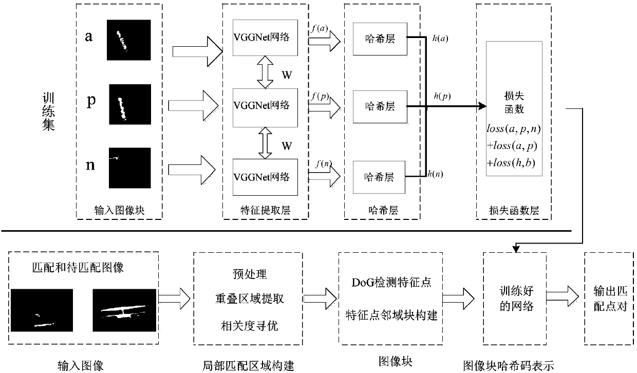
[0032] Such as figure 1 As shown, an aerial image matching method based on local depth hashing includes the following steps:

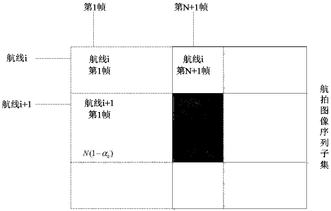
[0033] Step (1), calculate the interval number N of the image to be matched according to the overlap rate of the aerial image, and estimate the local matching area according to the requirement of the overlap rate;

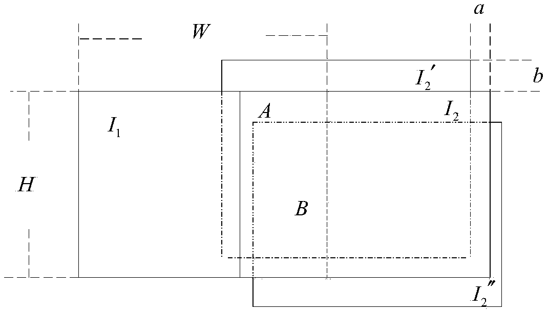
[0034] In step (2), the initially extracted local matching area of ​​the aerial image is shifted horizontally and vertically by a certain step length, and the local area is optimized by using the normalized cross-correlation algorithm;

[0035] Step (3), construct Triplet network structure based on VGG-F network as feature extraction network of the present invention, use hash layer to replace output layer as hash network of the present invention;

[0036] Step (4), improve based on traditional Triplet loss, increase absolute dista...


PUM


Abstract

The invention discloses an aerial image matching method based on local deep hashing. The method comprises the following steps: 1) calculating interval number N of an image to be matched according to aerial image overlapping ratio, and according to overlapping rate requirements, estimating a locally matched region; 2) carrying out optimization on the local region through a normalization cross-correlation algorithm; 3) constructing a Triplet network structure as a feature extraction network based on a VGG-F network, and replacing an output layer by a Hash layer to construct a Hash network; 4) carrying out improvement based on traditional Triplet loss, increasing absolute distance constraints and quantifying error loss as a loss function optimization network; and 5) detecting feature points according to a DoG algorithm and constructing feature point neighborhood as input of the network, obtaining a binary hash code of each image block through a trained network, and finishing matching in ahamming space through approximate nearest neighbor searching. The aerial image matching method based on local deep hashing has higher accuracy under the condition of meeting real-time performance.

Description

technical field [0001] The invention relates to an aerial image matching method, in particular to an aerial image matching method based on local depth hashing. Background technique [0002] In recent years, with the continuous development of aerial photography technology, high-resolution aerial photography remote sensing cameras have been successfully developed, and aerial photography images have been widely used in major demand fields such as emergency disaster relief, digital city construction, and engineering design. The rise provides a new idea for aerial image processing. An important prerequisite for aerial image processing is to obtain the physical and geometric information of the image, that is, the corresponding image features. The feature point extraction and matching of aerial images is the basis of image analysis, image fusion, change detection and stereo matching, and plays an important role in the field of aerial photography. [0003] Aerial images have the c...

Claims


Application Information

Patent Timeline
Patent Type & Authority Applications(China)
IPC IPC(8): G06K9/00G06K9/62G06N3/04G06N3/08
CPCG06N3/084G06V20/13G06V10/759G06V10/757G06N3/045
Inventor 陈苏婷李鑫张闯
Owner NANJING UNIV OF INFORMATION SCI & TECH
Why Eureka
Try Eureka