UAV line inspection system based on radio frequency tag and wireless relay remote transmission technology

A technology of radio frequency tags and wireless relays, which is applied in the field of UAV line inspection and detection systems, can solve the problems of not being able to cover the scheduled routes without blind spots, data quality is easily affected by environmental factors, and positioning accuracy cannot be guaranteed, so as to achieve guaranteed work Effects of monitoring, enriching application functions, and improving positioning practicality

Active Publication Date: 2021-06-22
常熟市天然气有限公司
View PDF5 Cites 0 Cited by
  • Summary
  • Abstract
  • Description
  • Claims
  • Application Information

AI Technical Summary

Problems solved by technology

The GPS system can achieve positioning, thus ensuring the cruising route, but the positioning has high requirements on the environment and the working range is limited
When the external environment is poor, such as cloudy sky, thick clouds, etc., the positioning accuracy cannot be guaranteed
At the same time, the positioning of the GPS system and the operator's base station cannot achieve the coverage of the scheduled route without blind spots, and there are positioning blind spots, so the reliability is poor
In addition, the wireless data remote transmission operation of the drone usually has a short transmission distance and a small bandwidth. Therefore, in order to ensure the quality of the returned video, the patrol range of the drone is small.
In addition, wireless remote transmission technology uses electromagnetic waves for data transmission, the data quality is easily affected by environmental factors, the anti-interference is weak, and the stability is poor, which greatly reduces its practicability

Method used


Image

  • UAV line inspection system based on radio frequency tag and wireless relay remote transmission technology
  • UAV line inspection system based on radio frequency tag and wireless relay remote transmission technology
  • UAV line inspection system based on radio frequency tag and wireless relay remote transmission technology

Examples


Embodiment Construction

[0031] The present invention will be further described below in conjunction with the accompanying drawings and specific embodiments.

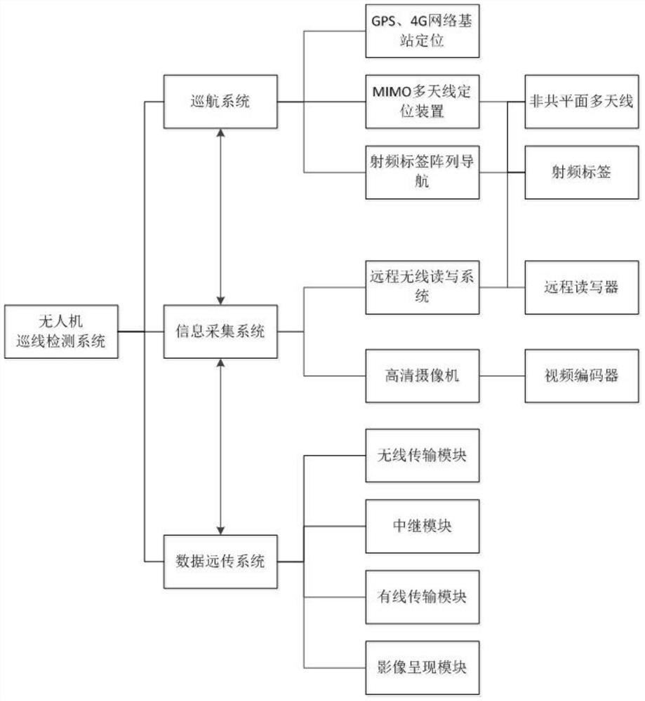
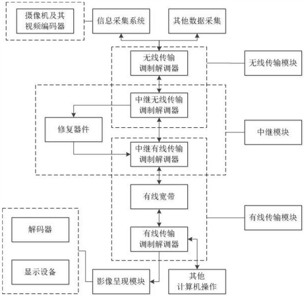
[0032] The UAV line inspection detection system realizes line inspection monitoring and detection operations through the cruise system, information collection system and data remote transmission system. Its overall structure is as follows: figure 1 shown.

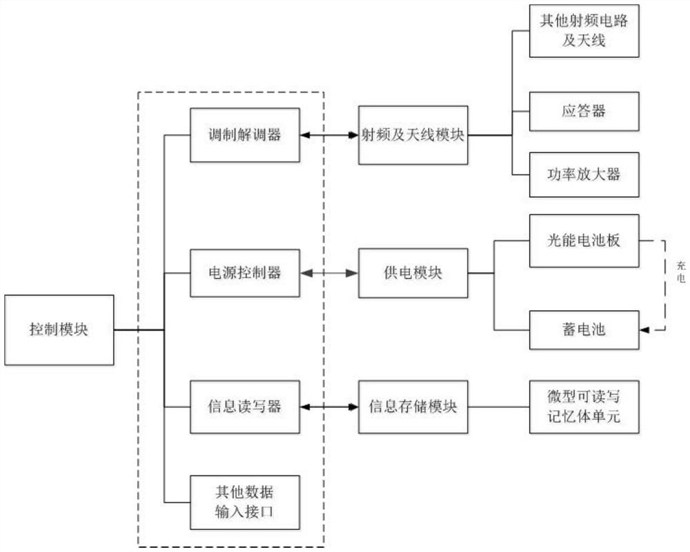
[0033] The cruise system first uses GPS or 4G network base station positioning technology for rough positioning, and then achieves a more accurate and reliable cruise effect through non-coplanar MIMO relative positioning and radio frequency tag array positioning. The wireless reader on the UAV remotely activates the radio frequency tags on the route, and determines the relative distance according to the signal arrival time TOA fed back by the radio frequency tags. There is a time difference of arrival (TDOA) in time, from which the relative ball angle can be calculated, and then the relative ...


PUM


Abstract

The invention discloses an unmanned aerial vehicle line inspection detection system based on radio frequency tags and wireless relay remote transmission technology applied in the field of unmanned aerial vehicles. Its structure includes a cruise system, an information collection system and a data remote transmission system. The cruise system includes: GPS equipped with the drone, 4G network base station, MIMO multi-antenna positioning device and radio frequency tags. The information collection system includes a high-definition camera and a long-distance wireless reader system corresponding to the radio frequency tag, the data remote transmission system is used to transmit the collected information of the information collection system to the terminal server. The radio frequency tags in the UAV line inspection system are placed in the corresponding positions according to the needs, which effectively improves the application range of the positioning device, avoids the existence of positioning blind spots, reduces the impact of environmental factors on positioning accuracy, and ensures the work survey effect . Then the information collection system transmits its information to the remote terminal through the data remote transmission system, which effectively guarantees the quality of line inspection and detection efficiency.

Description

technical field [0001] The invention relates to an unmanned aerial vehicle line inspection system based on radio frequency tags and wireless relay remote transmission technology applied in the field of unmanned aerial vehicles. Background technique [0002] With the advancement of science and technology, the application range of UAV line inspection technology in production and life has gradually expanded. This technology uses unmanned aerial vehicles to realize line inspection and monitoring operations, and the staff only need to control the inspection line of the unmanned aerial vehicles to realize long-distance survey operations, which reduces the labor intensity of the staff, improves work efficiency, and realizes cost reduction. During use, the UAV uses GPS or the operator's base station positioning technology to reach the survey destination, and then conducts monitoring operations with tools such as cameras, and then performs real-time video transmission through wirele...

Claims


Application Information

Patent Timeline
Patent Type & Authority Patents(China)
IPC IPC(8): H04B7/0413H04B7/155H04N7/18H04W4/02H04W4/44H04W4/80G06K7/10H02J50/40
CPCG06K7/10297H04B7/0413H04B7/155H04N7/18H04W4/025H02J50/40H04W4/44H04W4/80
Inventor 金科付毅郎子赵志强
Owner 常熟市天然气有限公司
Why Eureka
Try Eureka