Picture geographic location method and system based on large-scale street view data

A geographical positioning and large-scale technology, applied in the direction of digital data processing, special data processing applications, character and pattern recognition, etc., can solve only local optimal solutions, low positioning accuracy, slow matching speed of street view pictures, etc. problem, to achieve the effect of low time complexity, fast matching speed and short matching time

Active Publication Date: 2018-11-06
SHENZHEN GRADUATE SCHOOL TSINGHUA UNIV
View PDF6 Cites 9 Cited by
  • Summary
  • Abstract
  • Description
  • Claims
  • Application Information

AI Technical Summary

Problems solved by technology

[0005] In order to solve the problems of slow matching speed of street view pictures, only local optimal solutions can be obtained and low positioning accuracy, the present invention discloses a picture geolocation method b

Method used


Image

  • Picture geographic location method and system based on large-scale street view data
  • Picture geographic location method and system based on large-scale street view data
  • Picture geographic location method and system based on large-scale street view data

Examples


Embodiment Construction

[0023] The present invention will be further described below in conjunction with the accompanying drawings and specific embodiments.

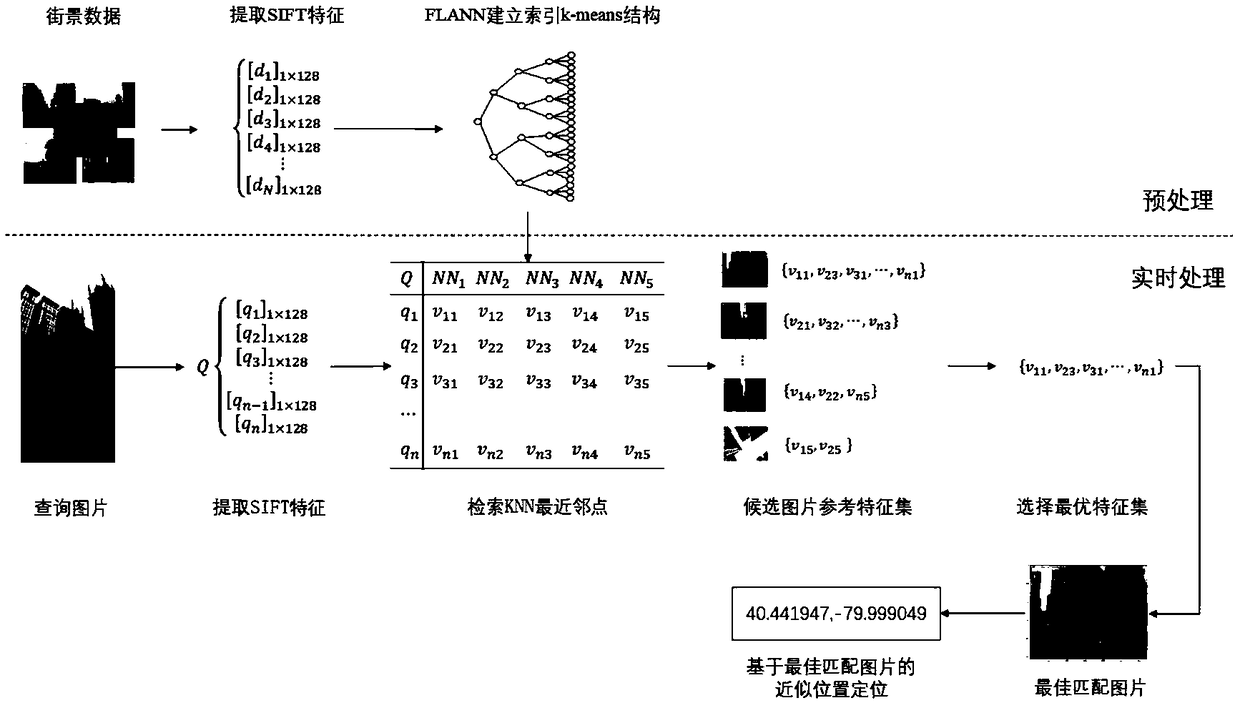
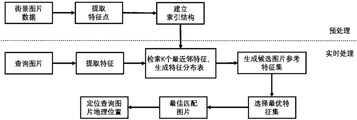
[0024] Such as figure 1 As shown, the image geolocation method based on large-scale street view data includes a preprocessing part that can be processed offline (either at the terminal or on a server), and a real-time matching (real-time processing) part to be processed online.

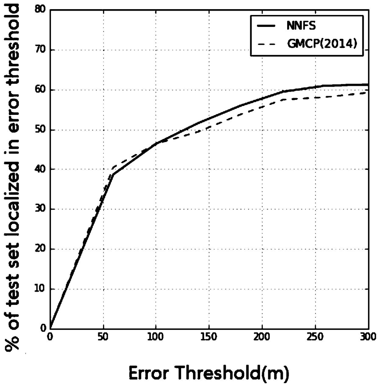
[0025] For the street view data set, more than 102K Google Street View images with GPS tags released by Zamir are used here. The test data set uses 644 pictures with GPS tags randomly uploaded by users from Flickr, Panoramio and Picasa. This specific embodiment is executed under the Python2.7 scripting language under the Ubuntu environment on the server, wherein the server memory needs at least 100G; in alternative embodiments, if the amount of data is large, the computer, mobile electronic device or server may need more memory. Such as figure 2 Shown is a visualiza...


PUM


Abstract

The invention discloses a picture geographic location method based on large-scale street view data and a system for realizing the method. The method comprises a real-time matching part, namely the following steps: extracting local feature points from a queried picture as query feature points, and generating a query feature set; in an index structure, searching K nearest neighbor feature points foreach query feature point, and generating a nearest neighbor feature distribution table; obtaining a nearest neighbor feature set of a candidate picture by virtue of the nearest neighbor feature distribution table; and selecting a candidate picture corresponding to an optimal feature set in the nearest neighbor feature set as an optimal matched picture, wherein a geographic location correspondingto the matched picture is regarded as the geographic location of the queried picture, and K is an integer. The method also can comprise a preprocessing part preferably, namely a time-consuming 'indexstructure creating part' which is separately processed in advance. The method and system which are disclosed by the invention has the characteristics that location accuracy is high, matching speed ishigh and globally optimal solution can be found.

Description

technical field [0001] The present invention relates to the technical field of image positioning, in particular to a method and system for image geographic positioning based on large-scale street view data. Background technique [0002] Image geolocation is to determine or estimate the geographic location of an image based on its visual information. This problem has many application scenarios, such as automatic driving of cars, mobile terminal navigation, video geographic trajectory generation, etc. In recent years, street view images have been continuously updated and improved, and in some cities, full coverage of street views can be achieved. There are many identifiable visual information in the picture, such as buildings, billboards, etc. We can use the method based on feature matching to identify these information, so as to achieve the purpose of geographical location of the picture. [0003] In the field of academic research, authors such as Zamir proposed that each q...

Claims


Application Information

Patent Timeline
IPC IPC(8): G06F17/30G06K9/62
CPCG06F18/22
Inventor 张凯邓文泉董宇涵
Owner SHENZHEN GRADUATE SCHOOL TSINGHUA UNIV
Why Eureka
Try Eureka