Display method of guide line in navigation map and mobile terminal

A navigation map and mobile terminal technology, which is applied in the field of map navigation, can solve the problems of road line confusion, overlap, and guide lines that cannot be indicated by the user's line, and achieve the effect of improving the effect of line indication

Active Publication Date: 2018-11-13
TENCENT TECH (SHENZHEN) CO LTD
View PDF11 Cites 8 Cited by
  • Summary
  • Abstract
  • Description
  • Claims
  • Application Information

AI Technical Summary

Problems solved by technology

In the navigation system provided by the prior art, technicians mostly focus on how to optimize route calculation and better display navigation map information, and contribute a variety of calculation methods with different factors as priority. The leading lines displayed by various navigation products and map products are all in the form of simple straight lines
In the prior art, the map usually uses a straight line when displaying the line image of the route guidance plan, and the effect is not good when displayed in a large scale, especially in areas with narrow road sections, where the straight line guide line is likely to be confused with the actual road line At this time, in order to see the route clearly, the user has to manually zoom in on the map, but it will still cause the straight guide line to overlap with the road line, so that the guide line cannot effectively indicate the route to the user.

Method used


Image

  • Display method of guide line in navigation map and mobile terminal
  • Display method of guide line in navigation map and mobile terminal
  • Display method of guide line in navigation map and mobile terminal

Examples


Embodiment Construction

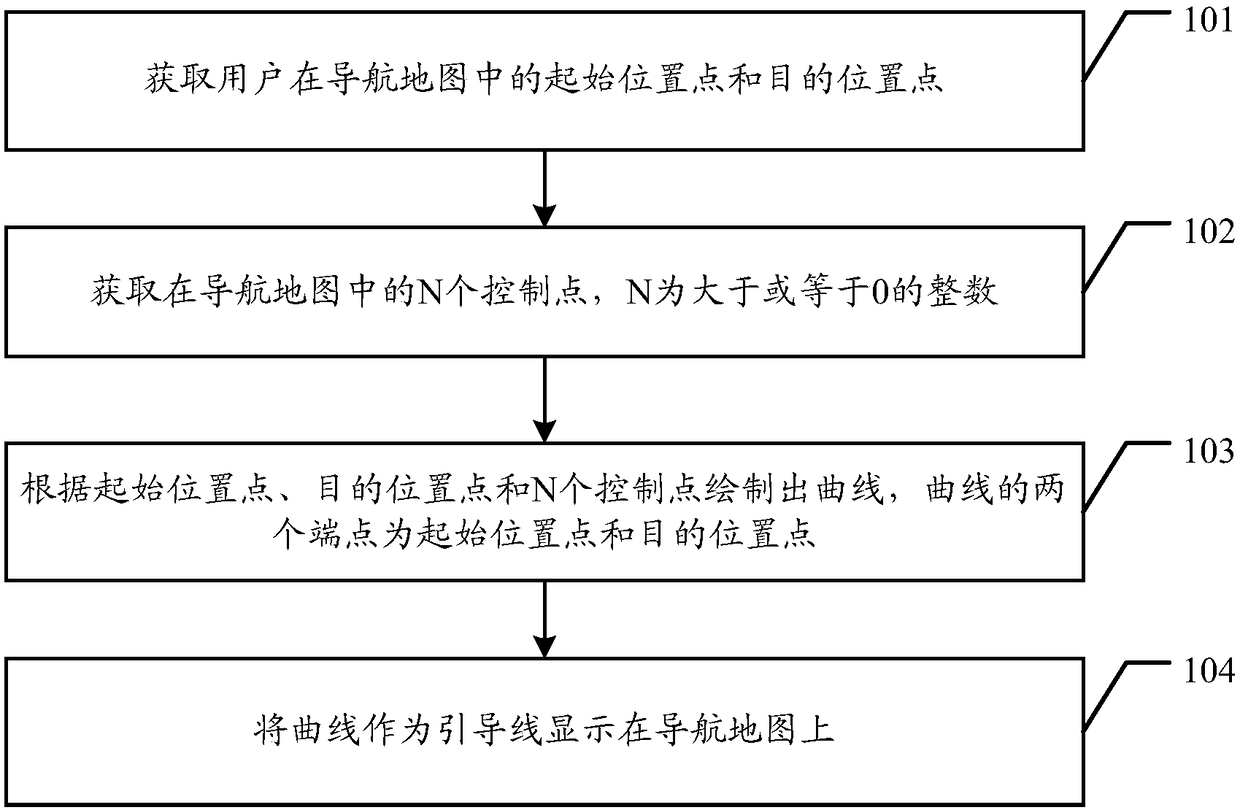
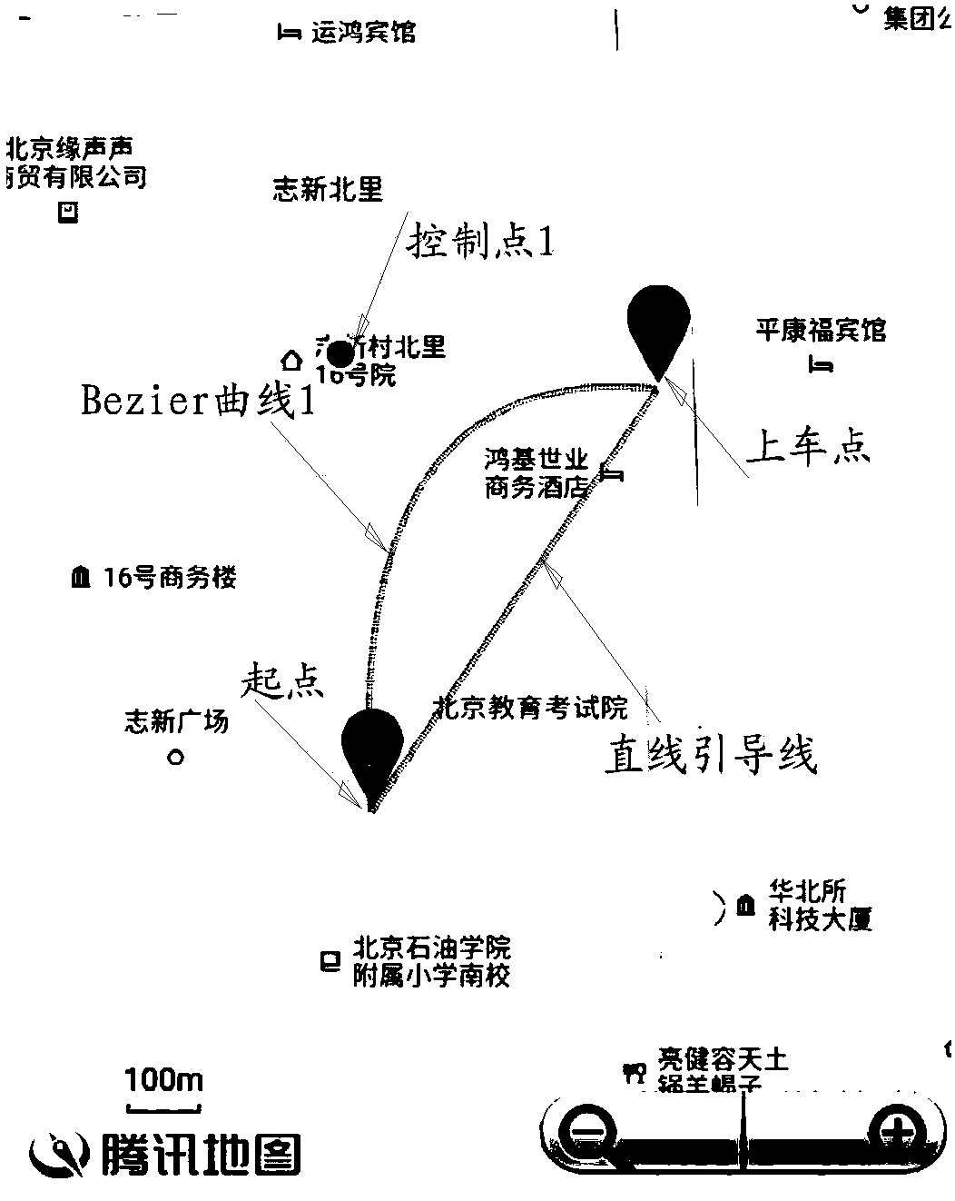
[0034] Embodiments of the present invention provide a method for displaying guidelines in a navigation map and a mobile terminal, which are used for prompting the guidelines on the navigation map through curved guidelines, without being confused with road lines, and improving the route indication effect.

[0035] In order to make the purpose, features and advantages of the present invention more obvious and understandable, the technical solutions in the embodiments of the present invention will be clearly and completely described below in conjunction with the accompanying drawings in the embodiments of the present invention. Obviously, the following The described embodiments are only some, not all, embodiments of the present invention. All other embodiments obtained by those skilled in the art based on the embodiments of the present invention belong to the protection scope of the present invention.

[0036] The terms "comprising" and "having" in the description and claims of t...


PUM


Abstract

An embodiment of the invention discloses a display method of a guide line in a navigation map and a mobile terminal. Prompting effect is realized on the navigation map through a curved guide line, andmixing with map mark road lines is avoided, so that map mark hierarchy is clearer, and line hinting effect is improved. The display method includes: acquiring a starting position point and a target position point of a user on the navigation map; acquiring N control points in the navigation map, wherein N is an integer greater than or equal to 0; drawing a curve according to the starting positionpoint, the target position point and the N control points, wherein the starting position point and the target position point serve as two end points of the curve; displaying the curve as the leading line on the navigation map.

Description

technical field [0001] The invention relates to the technical field of map navigation, in particular to a method for displaying guidelines in a navigation map and a mobile terminal. Background technique [0002] With the development of urban traffic network, the navigation system based on mobile positioning and wireless Internet technology plays an important role in map guidance. A navigation system is a collection of basic functions, including: positioning, destination selection, route calculation and route guidance. The navigation system also offers a color map display in its higher performance range, all of which require a digitized map. [0003] Among them, positioning means that the mobile communication system obtains the geographic location information (such as longitude and latitude coordinates, altitude, speed, etc.) of the mobile terminal through a specific positioning technology, and provides it to the mobile user himself, the communication system or a third-party...

Claims


Application Information

Patent Timeline
Patent Type & Authority Applications(China)
IPC IPC(8): G01C21/36
CPCG01C21/3667G01C21/3676G01C21/36
Inventor 崔志强
Owner TENCENT TECH (SHENZHEN) CO LTD
Why Eureka
Try Eureka