Method for exporting high-capacity geographic spatial data to be VCT files

A geospatial data, large-capacity technology, applied in electrical digital data processing, special data processing applications, instruments, etc., can solve problems such as the limitation of external memory storage capacity, inability to export large-volume spatial data, and achieve high reliability. , efficient and fast conversion, strong practical effect

Active Publication Date: 2018-11-23
爬山虎科技股份有限公司
View PDF5 Cites 8 Cited by
  • Summary
  • Abstract
  • Description
  • Claims
  • Application Information

AI Technical Summary

Problems solved by technology

However, this export method needs to store all the data to be exported in the memory. Compared with the externa

Method used


Image

  • Method for exporting high-capacity geographic spatial data to be VCT files
  • Method for exporting high-capacity geographic spatial data to be VCT files
  • Method for exporting high-capacity geographic spatial data to be VCT files

Examples


Embodiment Construction

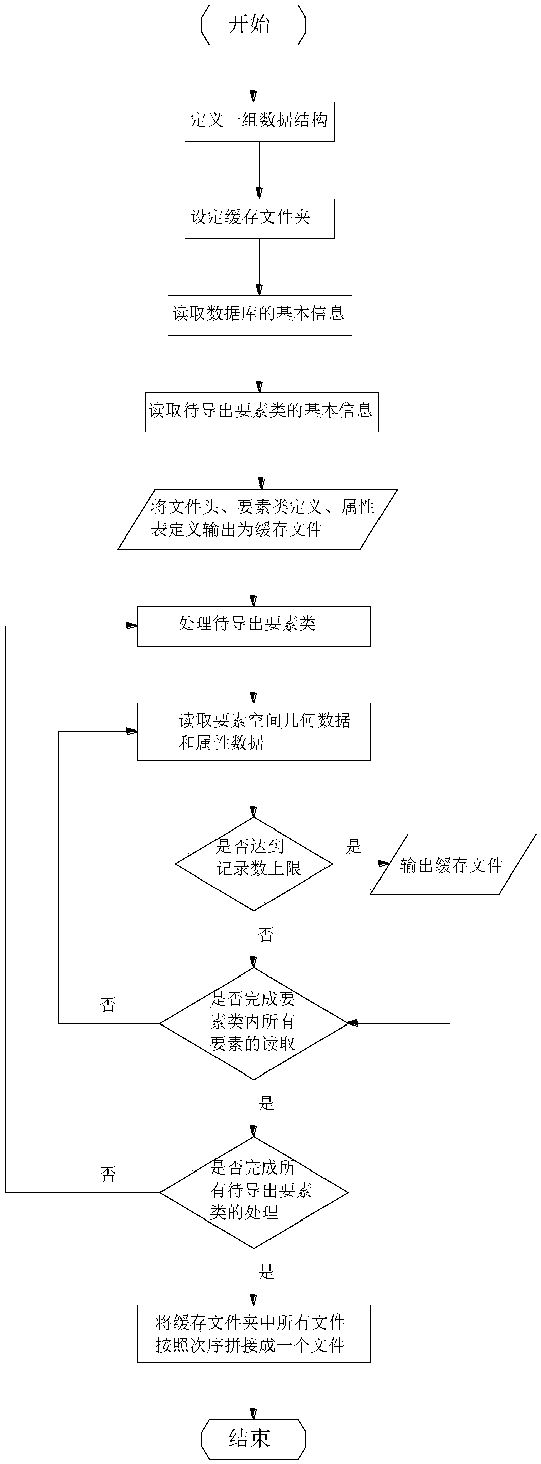
[0046] Below in conjunction with accompanying drawing, the present invention is further described:

[0047] A method for exporting large-capacity geospatial data to a VCT file, comprising the following steps:

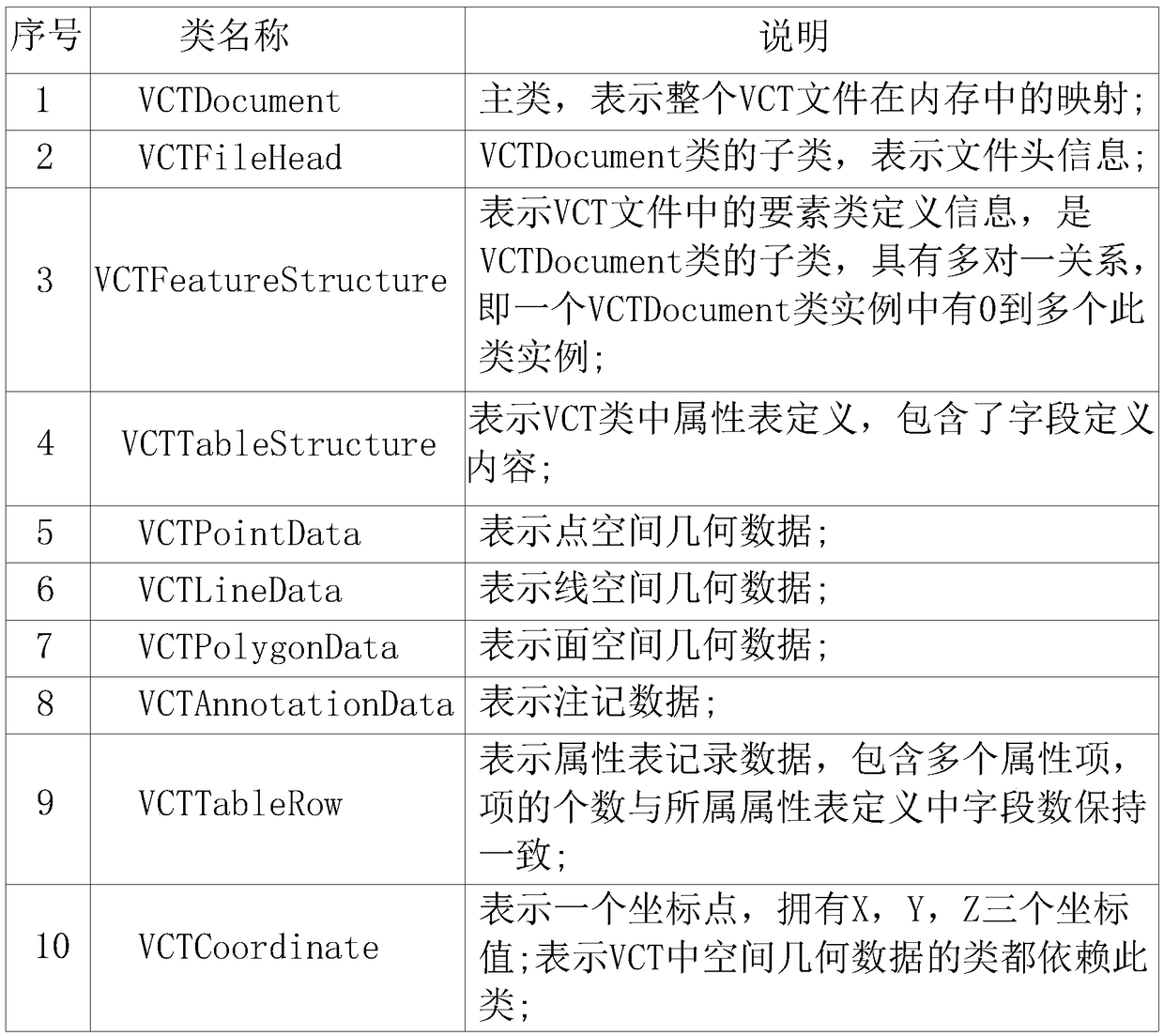
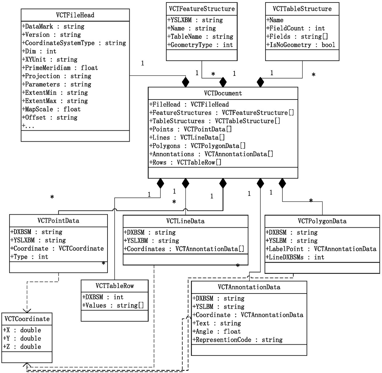
[0048] a. Define a set of data structures with reference to the VCT file structure in advance, for storage and organization of geospatial data in memory;

[0049] b. Set a cache folder in the file system;

[0050] c. read the basic information of the database from the spatial database, and load it into the data structure corresponding to the file header in the VCT file in the memory;

[0051] D. read the basic information of the feature class to be exported from the spatial database, and load it into the data structure corresponding to the feature class definition and the attribute table definition in the VCT file in the memory;

[0052] E. write the contents of the three parts of the file header, the feature class definition and the attribute table definition into th...


PUM


Abstract

The invention discloses a method for exporting high-capacity geographic spatial data to be VCT files, belongs to the field of geographic information system data exchange, and aims at solving the problem that spatial data with big data sizes cannot be exported to be VCT files at present. The method mainly comprises the operation steps of: pre-defining a group of data structure through referring toa VCT file structure; setting a cache folder; reading basic information of a database; reading basic information of to-be-exported feature classes; writing file header/feature class definition/attribute table definition into a cache file; processing the to-be-exported feature classes; and splicing the to-be-exported feature classes into a big file. The method is capable of thoroughly solving the problem that the operation of exporting high-capacity spatial data to be VCT files is limited by memories, is ingenious in conception and high in reliability, is capable of efficiently realizing rapidconversion between high-capacity spatial data and VCT files, has strong practicability and has significance in the field of geographic information system exchange.

Description

technical field [0001] The invention belongs to the field of geographic information system data exchange, and in particular relates to a method for exporting VCT files from large-capacity geographic space data. Background technique [0002] VCT is a vector data exchange format stipulated in the current national standard "GB / T 17798-2007 Geospatial Data Exchange Format". establish an exchange standard. [0003] The VCT file consists of eight parts: 1) file header, describing the basic characteristics of the data, including data range, coordinate dimension, mathematical basic information, etc.; 2) element type parameters; 3) attribute data structure; 4) spatial geometry data; 5) Annotation data; 6) Spatial topology data; 7) Attribute data; 8) Graphic representation data. The contents of the above eight parts are stored in the text file in sequence. [0004] The popular geographic information systems in the industry generally use spatial databases to manage data, and store s...

Claims


Application Information

Patent Timeline
IPC IPC(8): G06F17/30
Inventor 郭胜涛王伟光杨坤田贺
Owner 爬山虎科技股份有限公司
Why Eureka
Try Eureka