A three -dimensional model modeling method based on lane -level high -precision map

A technology of 3D model and modeling method, applied in 3D modeling, image enhancement, image analysis and other directions, can solve problems such as insufficient information, achieve the effect of convenient operation and reduce workload

Active Publication Date: 2022-08-09
广东星舆科技有限公司
View PDF10 Cites 0 Cited by
  • Summary
  • Abstract
  • Description
  • Claims
  • Application Information

AI Technical Summary

Problems solved by technology

[0005] In view of the above reasons, the present invention provides a road three-dimensional modeling method based on a lane-level high-precision map to solve the technical problem that the information displayed by the traditional two-dimensional navigation map is not rich enough to make the driver feel personally on the scene

Method used


Image

  • A three -dimensional model modeling method based on lane -level high -precision map
  • A three -dimensional model modeling method based on lane -level high -precision map
  • A three -dimensional model modeling method based on lane -level high -precision map

Examples


Embodiment Construction

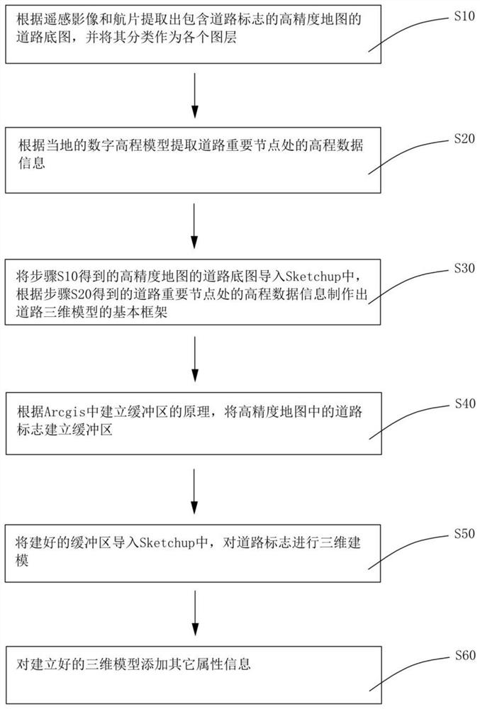
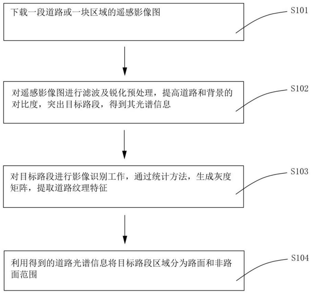
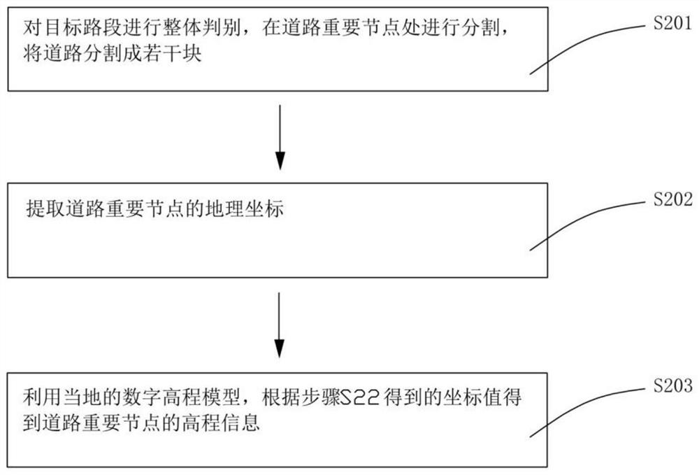
[0049] The technical solutions in the embodiments of the present invention will be clearly and completely described below in conjunction with the accompanying drawings in the embodiments of the present invention. Obviously, the described embodiments are only a part of the embodiments of the present invention, rather than all the embodiments. . Based on the embodiments of the present invention, all other embodiments obtained by those of ordinary skill in the art without creative efforts shall fall within the protection scope of the present invention.

[0050] It should be noted that the terms used in the embodiments of the present invention are only for the purpose of describing specific embodiments, and are not intended to limit the present invention. As used in the embodiments of the present invention and the appended claims, the singular forms "a," "the," and "the" are intended to include the plural forms as well, unless the context clearly dictates otherwise. It will also ...


PUM


Abstract

The present invention provides a road three-dimensional model modeling method based on a lane-level high-precision map, comprising the following steps: S10. Extract a road base map of a high-precision map according to remote sensing images and aerial photographs, and classify it as each layer ; S20. Extract the elevation data information at the important nodes of the road according to the local digital elevation model; S30. Import the road base map of the high-precision map into Sketchup, and create the basic framework of the 3D model of the road according to the elevation data information at the important nodes of the road ; S40. Create a buffer zone for the road signs in the high-precision map; S50. Import the created buffer zone into Sketchup to perform 3D modeling of the road signs; S60. Add other attribute information to the established 3D model. The present invention effectively combines remote sensing images, road information from actual aerial photography and terrain information reflected by the digital elevation model, which can reflect real road information.

Description

【Technical field】 [0001] The invention relates to the technical field of road three-dimensional modeling, in particular to a road three-dimensional model modeling method based on a lane-level high-precision map. 【Background technique】 [0002] With the development of GIS technology, computer technology and network technology, the realization of spatial digitization and virtualization to establish digital geospatial has become an important means for countries in the world to grasp the trend of high-tech and promote economic development, represented by digital cities, digital earth, etc. The digital geospatial plays an important role in land use supervision, spatial information management, urban system planning and management. The foundation of digital geospatial is the establishment of three-dimensional model of geographic data. The spatial data of road sections obtained by surveying and mapping methods basically belong to the 2D or 2.5D structure, which only expresses the p...

Claims


Application Information

Patent Timeline
Patent Type & Authority Patents(China)
IPC IPC(8): G06T17/05
CPCG06T17/05G06T2207/30256
Inventor 颉刚刘振宇李昱吴金恒
Owner 广东星舆科技有限公司
Why Eureka
Try Eureka