Method of calculating three-dimensional positions of ground points by using sequential satellite borne remote sensing images

A technology of optical remote sensing image and three-dimensional position, which is applied in the field of remote sensing image processing, can solve problems such as complex calculation process and unsuitable for large-scale engineering application, and achieve the effect of simplifying the calculation process

Active Publication Date: 2018-12-11
INST OF ELECTRONICS CHINESE ACAD OF SCI
View PDF1 Cites 4 Cited by
  • Summary
  • Abstract
  • Description
  • Claims
  • Application Information

AI Technical Summary

Problems solved by technology

[0003] Using serialized satellite optical remote sensing images to calculate the three-dimensional position of ground points, it is also possible to extract two images from the sequence images at a time to perform the conventional relative orientation and absolute orientation complex non-linear iterati

Method used


Image

  • Method of calculating three-dimensional positions of ground points by using sequential satellite borne remote sensing images
  • Method of calculating three-dimensional positions of ground points by using sequential satellite borne remote sensing images
  • Method of calculating three-dimensional positions of ground points by using sequential satellite borne remote sensing images

Examples


Embodiment Construction

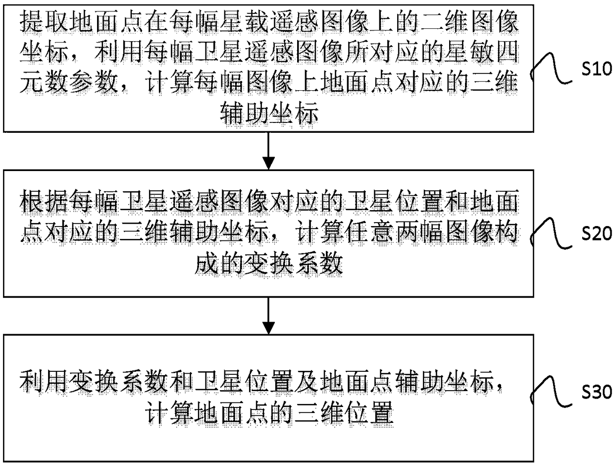
[0028] The present disclosure provides a method for calculating the three-dimensional position of a ground point using a sequence of satellite-borne optical remote sensing images, including firstly extracting the two-dimensional image coordinates of the ground point on each satellite-borne optical remote sensing image, and using each satellite-borne optical remote sensing image The corresponding star-sensitive quaternion parameters are used to calculate the three-dimensional auxiliary coordinates corresponding to the ground point on each satellite-borne optical remote sensing image; secondly, according to the satellite position corresponding to each satellite-borne optical remote sensing image and the three-dimensional auxiliary coordinate corresponding to the ground point, Calculate the transformation coefficients of any two satellite-borne optical remote sensing images; finally, calculate the three-dimensional position of the ground point by using the transformation coefficient...


PUM


Abstract

The invention provides a method of calculating three-dimensional positions of ground points by using sequential satellite borne remote sensing images. The method comprises the following steps: first,extracting two-dimensional image coordinates of the ground points on each satellite borne remote sensing image and calculating the three-dimensional auxiliary coordinates corresponding to the ground points on each satellite borne remote sensing image by using satellite sensitive quaternion parameters corresponding to each satellite borne remote sensing image; second, calculating the transformationcoefficient formed by any two satellite borne remote sensing images according to the satellite position corresponding to each satellite borne remote sensing image and the three-dimensional auxiliarycoordinates corresponding to the ground points; and finally, calculating the three-dimensional positions of the ground points by using the transformation coefficient, the satellite positions and the ground point auxiliary coordinates. The method directly calculates the three-dimensional positions of the ground points explicitly by applying platform parameters and camera parameters of the satelliteborne remote sensing images without initial approximate values of the ground points. Iterative and approximate processes are avoided in calculation, so that the calculating process is simplified effectively, and the method is more suitable for scaled engineering application.

Description

Technical field [0001] The present disclosure relates to the technical field of remote sensing image processing, and in particular to a method for calculating the three-dimensional position of a ground point by using a sequence of satellite-borne optical remote sensing images. Background technique [0002] Satellite-borne optical remote sensing images can only obtain ground two-dimensional image information after geometric positioning or geometric correction. In order to obtain ground three-dimensional position information, it is generally necessary to use stereo relative methods to obtain three-dimensional information of ground points. Stereo-relative is to calculate the three-dimensional position of the ground point based on the two images of the same area obtained by using the spatial geometric relationship. The conventional processing flow is to go through two processes of relative orientation and absolute orientation, and each process requires more complicated non- Linear it...

Claims


Application Information

Patent Timeline
IPC IPC(8): G01C11/06
CPCG01C11/06
Inventor 尤红建
Owner INST OF ELECTRONICS CHINESE ACAD OF SCI
Why Eureka
Try Eureka