A method for calculating the relative reachable region of a lost segment of a spacecraft tracking target

A technology of target loss and calculation method, which is applied to space navigation equipment, space navigation vehicles, space vehicle guidance devices, etc., can solve the problems of no research on the concept of relative reachable area, few literatures, etc.

Active Publication Date: 2019-01-08
NORTHWESTERN POLYTECHNICAL UNIV
View PDF7 Cites 4 Cited by
  • Summary
  • Abstract
  • Description
  • Claims
  • Application Information

AI Technical Summary

Problems solved by technology

However, none of them studied the concept of relative reachable area, so that the concept of reachable area cannot be a

Method used


Image

  • A method for calculating the relative reachable region of a lost segment of a spacecraft tracking target
  • A method for calculating the relative reachable region of a lost segment of a spacecraft tracking target
  • A method for calculating the relative reachable region of a lost segment of a spacecraft tracking target

Examples


Embodiment Construction

[0067] The present invention is described in further detail below in conjunction with accompanying drawing:

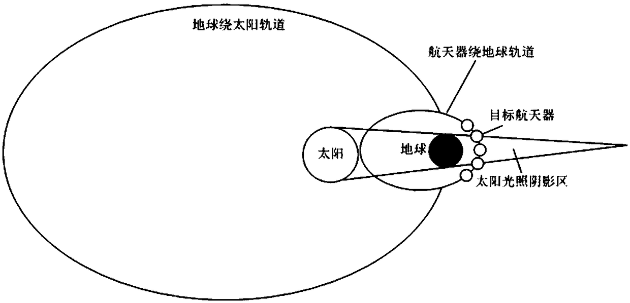
[0068] Such as figure 1 As shown, due to the rotation of the earth around the sun, the spacecraft in the orbit of the earth will always be blocked by the earth for a period of time. In this case, when the target spacecraft enters the shadow area, the camera is used as a sensor The tracking spacecraft will lose the observation of the target spacecraft, so the target may perform maneuvers in this lost segment, using the concept of relative reachable area to describe the relative motion between the target spacecraft and the tracking spacecraft, so that the tracking spacecraft The spacecraft has a comprehensive grasp of the position information of the target spacecraft.

[0069] The relative reachable area calculation method of the missing segment of the spacecraft tracking target of the present invention comprises the following steps:

[0070] 1) Establish the earth's i...


PUM


Abstract

The invention discloses a relative reachable area calculation method of a lost section of a spacecraft tracking target, comprising the following steps: 1) establishing an earth inertial coordinate system EXYZ and a target spacecraft orbit coordinate system Txyz, constructing a spacecraft relative motion orbit model, and solving the solution of the spacecraft relative motion orbit model; 2) according to that relative motion trajectory model of the spacecraft, adding the mechanical force exerte by the target spacecraft at any time to construct a new relative motion trajectory model of the spacecraft; 3) solving the analytical solution of the new spacecraft relative motion orbit model, and then take the analytical solution as the equation of the relative reachable region of the target spacecraft missing section. This method can calculate the relative reachable region of the target missing section of the spacecraft tracking.

Description

technical field [0001] The invention belongs to the technical field of relative movement of space vehicles, and relates to a method for calculating a relative reachable area of ​​a missing segment of a tracking target of a space vehicle. Background technique [0002] In recent years, with the demand of on-orbit service missions, the orbit prediction of target spacecraft has become more and more important. It is the premise to carry out further tasks on the target to keep track of the spacecraft's on-orbit information. However, when the tracking spacecraft observes the target, due to factors such as sunlight and earth shading, the target cannot be observed for a period of time. If the target spacecraft maneuvers during this period of time, the tracking spacecraft will Unable to successfully predict the position information of the target spacecraft in the next period, which will lead to the loss of the target. Therefore, using the concept of relative reachable area to calcul...

Claims


Application Information

Patent Timeline
IPC IPC(8): B64G1/24G06F17/11
CPCG06F17/11B64G1/242
Inventor 袁建平张军华岳晓奎李琪王伟高琛
Owner NORTHWESTERN POLYTECHNICAL UNIV
Why Eureka
Try Eureka