System and method for multiple conversion of surveying and mapping results catalog

A conversion system and conversion method technology, applied in the field of multiple conversion systems of surveying and mapping results catalogs, to achieve the effects of easy operation and implementation, sharing and application, and strong operability

Active Publication Date: 2020-12-04
山东省国土测绘院
View PDF12 Cites 0 Cited by
  • Summary
  • Abstract
  • Description
  • Claims
  • Application Information

AI Technical Summary

Problems solved by technology

[0006] A multi-conversion system and method for surveying and mapping results catalogs, which solves the problem of converting surveying and mapping results metadata at different logical levels or scattered surveying and mapping results metadata into surveying and mapping results catalogs, which is conducive to the sharing and application of surveying and mapping results resources

Method used


Image

  • System and method for multiple conversion of surveying and mapping results catalog
  • System and method for multiple conversion of surveying and mapping results catalog
  • System and method for multiple conversion of surveying and mapping results catalog

Examples


Embodiment Construction

[0040] The following will clearly and completely describe the technical solutions in the embodiments of the present invention with reference to the accompanying drawings in the embodiments of the present invention. Obviously, the described embodiments are only some, not all, embodiments of the present invention. Based on the embodiments of the present invention, all other embodiments obtained by persons of ordinary skill in the art without making creative efforts belong to the protection scope of the present invention.

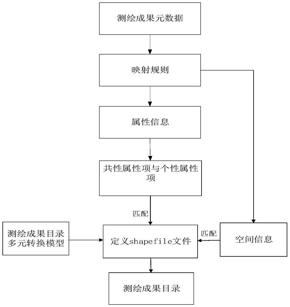
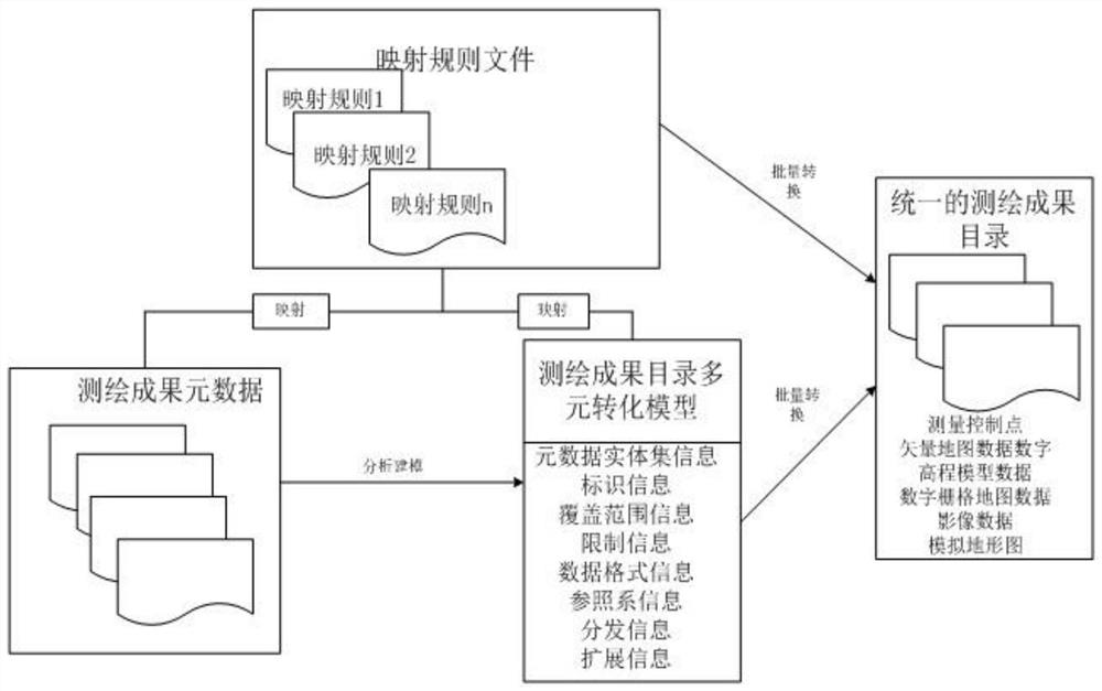
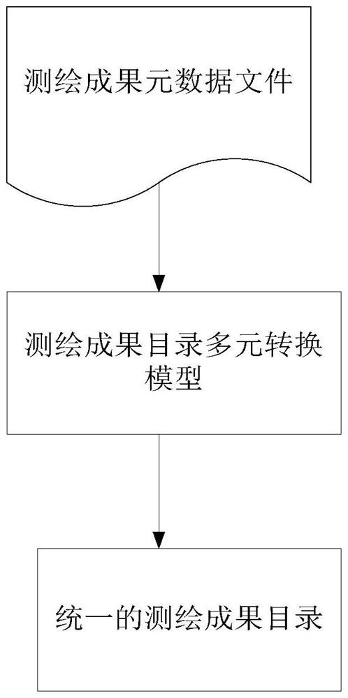
[0041] A multi-element conversion system for surveying and mapping results, such as figure 1 , figure 2 and Figure 4 As shown, by analyzing the metadata of the collected surveying and mapping results and constructing the type catalog of surveying and mapping results, survey control points, vector map data, digital elevation model data, digital raster map data, image data, and simulated topographic maps can be used as the first-level Classes can also be ext...


PUM


Abstract

A system and a method for multivariate conversion of a survey and map results catalogue are disclosed. A system and a method for multivariate conversion of a survey and map catalogue are analyzed, anda method for multivariate conversion of a survey and map catalogue in a Shapefile format of multi-type and multi-scale of an analog topographic map is formed, such as survey control point, vector mapdata, digital elevation model data, digital raster map data, image data and so on. The mapping rules from metadata of surveying and mapping results to multi-conversion model of surveying and mappingresults catalogue are established, and the mapping relationship between attribute information and spatial information of multi-conversion method of each type of surveying and mapping results metadataand surveying and mapping results catalogue is clarified. Based on the mapping rules, the mapping results metadata entity files are loaded in batches by the conversion tool, and the conversion tool automatically identifies the correlation of mapping results metadata--mapping rules--surveying and mapping results directory multi-conversion model, so automatic, fast and batch conversion is completed.

Description

technical field [0001] The invention relates to the technical field of spatial information processing, and in particular to a system and method for multiple conversion of surveying and mapping results catalogs. Background technique [0002] The catalog of surveying and mapping results is the result of combing and integrating surveying and mapping results resources, which can effectively promote the sharing and application of surveying and mapping results resources. At present, the main source of the catalog of surveying and mapping results is the metadata of surveying and mapping results. The surveying and mapping results have characteristics such as multi-scale, multi-type, and multi-source, which directly lead to the fact that the metadata of surveying and mapping results also has various types of results, inconsistent attribute information structures, multi-sources, and diversity. This has brought great difficulties to the publication and sharing of the catalog of surveyi...

Claims


Application Information

Patent Timeline
Patent Type & Authority Patents(China)
IPC IPC(8): G06F16/16G06F16/25
Inventor 李玉琳王福杰王凤娇孙海笑平宗玮王皎王珊
Owner 山东省国土测绘院
Why Eureka
Try Eureka