Browser-based Geospatial Information Bearing Method

A geospatial information and geographic information system technology, applied in digital data information retrieval, instruments, electronic digital data processing, etc., can solve problems affecting user experience, response speed, and difficulty in replacing desktop geographic information systems.

Active Publication Date: 2022-07-26
GEOVIS CO LTD
View PDF12 Cites 0 Cited by
  • Summary
  • Abstract
  • Description
  • Claims
  • Application Information

AI Technical Summary

Problems solved by technology

The emerging WebGIS technology depends on the browser and is restricted by various aspects of the browser, including security and display technology, which makes it difficult for WebGIS to replace the desktop geographic information system.
Compared with traditional desktop GIS, the limited interactive ability of WebGIS greatly affects the user experience effect. When the client browses GIS data, its response speed is also affected by the network bandwidth.
GIS has developed from 2D mode to 3D mode, and the limitation of WebGIS on the use of local computing resources also limits the effect of GIS 3D rendering

Method used


Image

  • Browser-based Geospatial Information Bearing Method
  • Browser-based Geospatial Information Bearing Method
  • Browser-based Geospatial Information Bearing Method

Examples


Embodiment Construction

[0028] The present invention will be described in further detail below with reference to the accompanying drawings and specific embodiments.

[0029] A browser-based method for carrying geospatial information, that is, using CEF that encapsulates the Chromium browser kernel to reconstruct a browser application, where the browser is the Chrome browser.

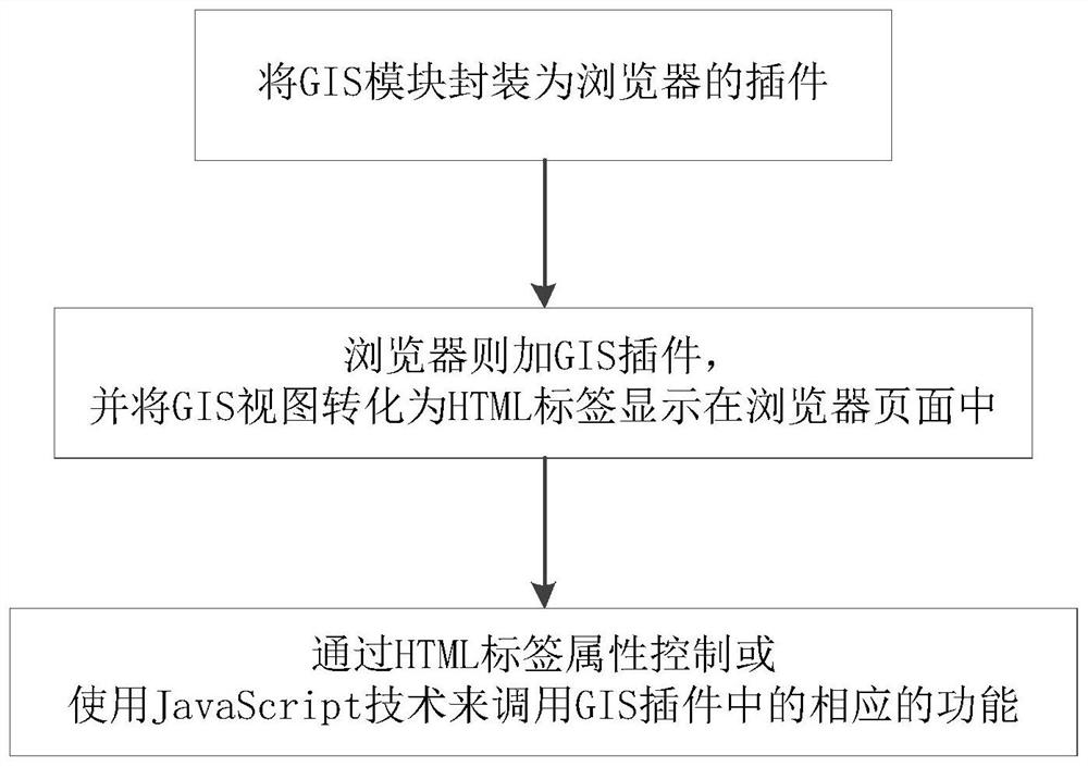
[0030] The specific process is as figure 1 As shown, the geographic information system (GIS) module is encapsulated as a browser plug-in, and the browser adds a GIS plug-in and converts the GIS view into HTML tags to display in the browser page, which is controlled by HTML tag attributes or invoked using JavaScript technology. Corresponding functions in the GIS plugin.

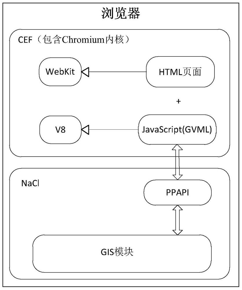
[0031] Among them, such as figure 2 As shown, the Chromium browser kernel includes two core engines, the WebKit engine and the V8 engine, where the WebKit engine is used to parse HTML page programs; and the V8 engine is used to interpret and execute JavaScri...


PUM


Abstract

The invention discloses a browser-based geospatial information bearing method, comprising: reconstructing a browser application program: encapsulating a geographic information system module as a browser plug-in, and the browser loads the geographic information system plug-in and converts the geographic information system The view is converted into HTML tags and displayed in the browser page, and the corresponding functions in the GIS plug-in are called through the HTML tag attribute control or using JavaScript technology. The beneficial effects of the invention are as follows: as a browser, all the advantages of WebGIS are retained; it is compatible with the strong interactive capability of the desktop geographic information system; it breaks through the limitation of the browser on the use of client hardware resources; the display effect of geographic information data surpasses that of WebGIS , equivalent to a desktop GIS.

Description

technical field [0001] The invention relates to the visualization field of geographic information systems, in particular to a browser-based method for carrying geographic spatial information. Background technique [0002] GIS (Geographic Information System, geographic information system) is a spatial information system that collects, stores, retrieves, analyzes and describes the entire or part of the earth's surface and spatial geographic distribution data [1]. It combines geographic location and related attributes organically, and outputs spatial information and attribute information to users in an accurate, true, graphic and textual manner according to the needs of users, to meet the needs of urban construction, enterprise management, residents' life, etc. For the requirements of spatial information, with its unique spatial analysis function and visual expression function, various auxiliary decision-making can be carried out. [0003] Desktop geographic information system...

Claims


Application Information

Patent Timeline
Patent Type & Authority Patents(China)
IPC IPC(8): G06F16/909G06F8/20
CPCG06F8/22
Inventor 吴方才曾刚曾飞传王焰辉
Owner GEOVIS CO LTD
Why Eureka
Try Eureka