Method for determining coordinates of tip of bucket through using GNSS and tilt sensor

An inclination sensor and sensor technology, which is applied in the direction of instruments, satellite radio beacon positioning systems, measuring devices, etc., can solve the problems of inability to carry out construction inspection, construction safety hazards, excavation construction and surveyor construction inspection cannot be carried out simultaneously, etc.

Pending Publication Date: 2019-03-08
NANJING TIANCHENLIDA ELECTRONICS TECH CO LTD
View PDF6 Cites 14 Cited by
  • Summary
  • Abstract
  • Description
  • Claims
  • Application Information

AI Technical Summary

Problems solved by technology

[0004] The construction efficiency is low, and the excavation construction and surveyor construction inspection cannot be carried out simultaneously
[0005] The samples for construction inspection are relatively small and cannot cover the entire operation process
[0006] The real-time performance is not enough, the surveyor will interrupt the construction process during the inspection, and cannot carry out the quality inspection of the operation in real time
[0007] It is not possible to work 24 hours a day. At night, if the l

Method used


Image

  • Method for determining coordinates of tip of bucket through using GNSS and tilt sensor
  • Method for determining coordinates of tip of bucket through using GNSS and tilt sensor
  • Method for determining coordinates of tip of bucket through using GNSS and tilt sensor

Examples


Embodiment Construction

[0027] In the following description, numerous specific details are given in order to provide a more thorough understanding of the present invention. It will be apparent, however, to one skilled in the art that the present invention may be practiced without one or more of these details. In other examples, some technical features known in the art are not described in order to avoid confusion with the present invention.

[0028] In order to thoroughly understand the present invention, detailed steps and detailed structures will be provided in the following description, so as to illustrate the technical solution of the present invention. Preferred embodiments of the present invention are described in detail below, however, the present invention may have other embodiments besides these detailed descriptions.

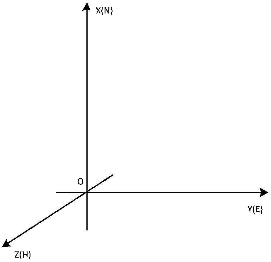
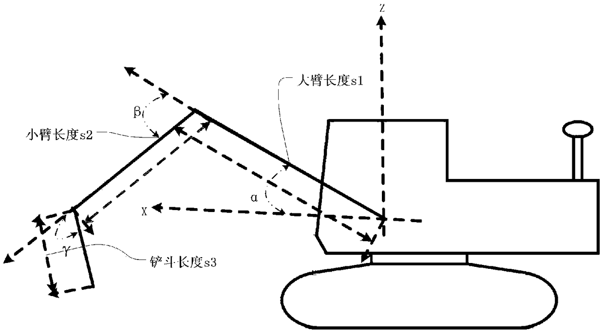
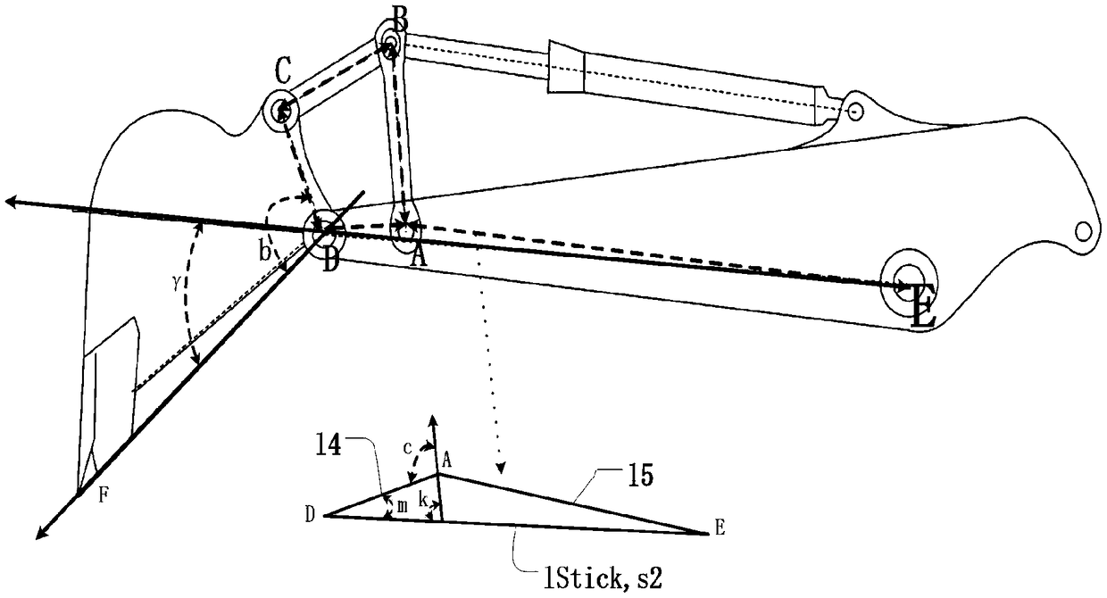
[0029] refer to Figure 1-Figure 3 As shown, a method for determining bucket tip coordinates using GNSS and an inclination sensor provided by the present invention is appli...


PUM


Abstract

The invention provides a method for determining the coordinates of the tip of a bucket through using a GNSS and a tilt sensor. The method comprises the following steps that: step (1) main antenna GNSSgeodetic latitude and longitude coordinates and a geodetic azimuth are acquired; step (2) the geodetic latitude and longitude coordinates are converted into engineering coordinates, and the geodeticazimuth is converted into an engineering coordinate azimuth; step (3) a vehicle body coordinate system-to-engineering coordinate system transition matrix is calculated according to the numerical values of vehicle body sensors and the coordinate azimuth; step (4) the vehicle body coordinate system coordinates of the tip of the bucket are calculated according to the numerical values of the sensors on an upper arm, a forearm and a rocker and a mechanical model; and step (5) the engineering coordinates of the tip of the bucket are calculated according to the transition matrix and the vehicle bodycoordinate system coordinates. According to the method of the invention, high-accuracy Beidou navigation and positioning technologies are adopted; a GNSS coordinate-to-engineering coordinate transformation algorithm is adopted to convert the GNSS coordinates (B, L, H) into the engineering coordinates (N, E, H), so that the engineering coordinates of a GNSS antenna can be obtained in real time.

Description

technical field [0001] The invention relates to the field of Beidou digital construction, in particular to a method for determining the coordinates of a bucket tip by using GNSS and an inclination sensor. Background technique [0002] In recent years, the country's basic design and construction has developed rapidly, and the domestic construction field has higher and higher requirements for construction quality and precision. At the same time, the country advocates energy conservation and environmental protection, which poses new challenges to the traditional construction field. [0003] At present, when domestic excavators are used for fine construction, at least one surveyor and excavator operator are generally required to carry out joint operations. If high-precision high-ring operations are carried out on the proving ground, there may even be 3 to 4 surveyors and one operator. Joint excavator operators work together. At the same time, the traditional operation method ha...

Claims


Application Information

Patent Timeline
IPC IPC(8): G01S19/45
CPCG01S19/45
Inventor 沈礼伟杨红刘理想毛凌陈文学
Owner NANJING TIANCHENLIDA ELECTRONICS TECH CO LTD
Why Eureka
Try Eureka