Electronic chart-based auxiliary information indicating system for navigation safety in complex sea areas

A technology of auxiliary information and electronic charts, applied in navigation, surveying and navigation, navigation calculation tools, etc., can solve the problems of mapping and auxiliary decision-making, single function, safety indication of incapable navigation process, etc., to facilitate convenient access, improve Cognitive effect, information update saving effect

Active Publication Date: 2019-03-15
NAVAL UNIV OF ENG PLA
View PDF5 Cites 16 Cited by
  • Summary
  • Abstract
  • Description
  • Claims
  • Application Information

AI Technical Summary

Problems solved by technology

[0010] Aiming at at least one defect or improvement requirement of the prior art, the present invention provides an electronic chart-based auxiliary information i

Method used


Image

  • Electronic chart-based auxiliary information indicating system for navigation safety in complex sea areas
  • Electronic chart-based auxiliary information indicating system for navigation safety in complex sea areas
  • Electronic chart-based auxiliary information indicating system for navigation safety in complex sea areas

Examples


Example Embodiment

[0044] In order to make the objectives, technical solutions, and advantages of the present invention clearer, the following further describes the present invention in detail with reference to the accompanying drawings and embodiments. It should be understood that the specific embodiments described here are only used to explain the present invention, but not to limit the present invention. In addition, the technical features involved in the various embodiments of the present invention described below can be combined with each other as long as they do not conflict with each other.

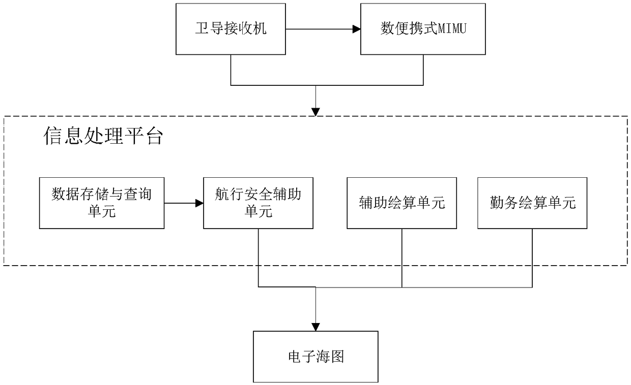
[0045] figure 1 It is a logical block diagram of an electronic chart-based navigational safety auxiliary information indicating system for complex sea areas provided by this embodiment, such as figure 1 As shown, this complex maritime navigation safety auxiliary information indication system includes an information processing platform, a satellite navigation receiver, and a portable miniature inertial me...


PUM


Abstract

The invention discloses an electronic chart-based auxiliary information indicating system for navigation safety in complex sea areas. The system comprises an information processing platform, wherein adata storage and inquiry unit and a navigation safety auxiliary unit are instantiated inside the information processing platform; the navigation safety auxiliary unit is used for obtaining navigationsafety auxiliary information from the data storage and inquiry unit and inserting the information into an electronic chart in a form of independent layer; a corresponding object mark is generated ona display interface of the electronic chart; and when an externally input touch screen instruction on the object mark is received or navigation information indicates that a ship enters a key area, thecorresponding navigation safety auxiliary information is displayed on the electronic chart. According to the invention, the graphic integrated display of the various navigation safety auxiliary information is achieved based on the electronic chart, so that the various navigation safety auxiliary information can be timely, comprehensively, intuitively and conveniently learned about by seafaring personnel; and various navigation auxiliary plotting can be achieved, so that decisions on location, navigation, risk avoiding and sheering can be fast and correctly made.

Description

technical field [0001] The invention belongs to the technical field of navigation information application, and more specifically relates to an electronic chart-based auxiliary information indication system for navigation safety in complex sea areas. Background technique [0002] Complex sea areas mainly refer to sea areas where the hydrological and meteorological conditions are complex and changeable, the navigable waters are narrow, the waterways are multi-turned and converged, the obstacles are many and complex, and various types of ships are active, and the navigation environment is complex, which makes safe navigation difficult, such as Zhoushan and Penghu Sea Area, Seto Inland Sea in Japan, Strait of Malacca, Great Barrier Reef in Australia, Baltic Sea in Europe, etc. Such sea areas are prone to navigation safety accidents such as collisions, grounding, and grounding. Taking Zhoushan sea area as an example, there were 27 collision accidents between commercial ships and ...

Claims


Application Information

Patent Timeline
IPC IPC(8): G01C21/20
CPCG01C21/203
Inventor 李安卞鸿巍马恒王荣颖温潮江刘文超
Owner NAVAL UNIV OF ENG PLA
Why Eureka
Try Eureka