Urban impervious surface and DEM (digital elevation model)-based urban surface runoff detecting method

A technology for surface runoff and detection methods, which is applied to measurement devices, material analysis by optical means, instruments, etc., can solve the problems of complexity, increase in errors, and information confusion, and achieve the effect of good input and support, and accurate detection.

Inactive Publication Date: 2019-03-19
INST OF REMOTE SENSING & DIGITAL EARTH CHINESE ACADEMY OF SCI
View PDF4 Cites 5 Cited by
  • Summary
  • Abstract
  • Description
  • Claims
  • Application Information

AI Technical Summary

Problems solved by technology

The core work of the SCS-CN model is to estimate the CN (Curve Number) value. The traditional CN value estimation method is relatively complicated. Therefore, Fan et al. (2013) creatively proposed an improved CN value calculation method based on impervious surfaces. This method is based on the V-I-S (Vegetation-Impervious Surface-Soil) model proposed by Ridd (1995) to characterize the urban biophysical composition, and the impervious surface coverage, soil coverage, vegetation coverage and the initial CN value are weighted by area ratio Get the synthetic CN value
However, due to human factors and impervious surfaces that are easily confused with sand and rock information, coupled with some human factors and other issues, the error in extracting impervious surfaces, soils, and vegetation using the linear spectral mixed decomposition method (LSMA) will increase.

Method used


Image

  • Urban impervious surface and DEM (digital elevation model)-based urban surface runoff detecting method
  • Urban impervious surface and DEM (digital elevation model)-based urban surface runoff detecting method
  • Urban impervious surface and DEM (digital elevation model)-based urban surface runoff detecting method

Examples


Embodiment Construction

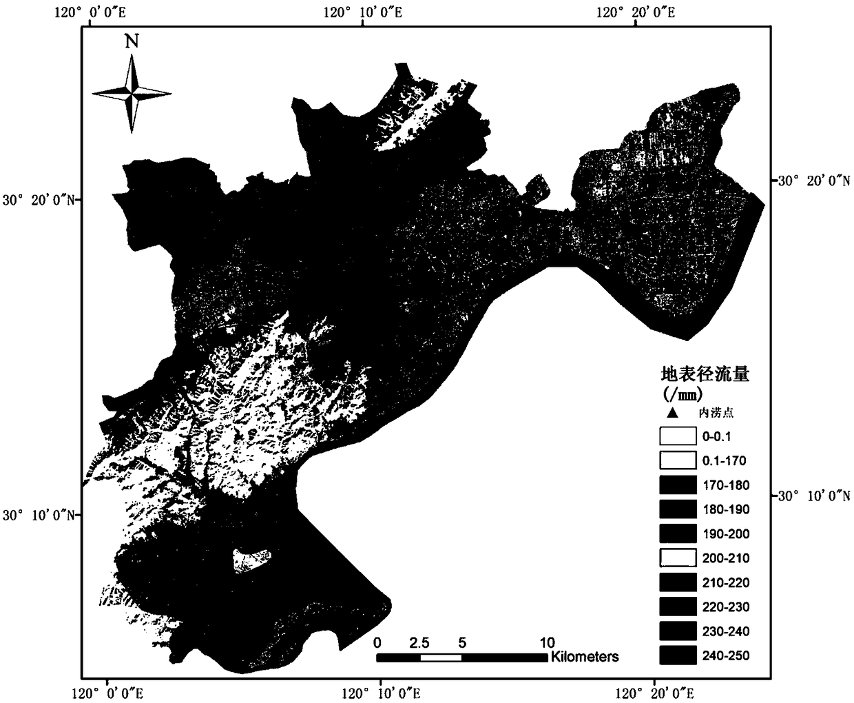
[0024] The present invention "a method for detecting urban surface runoff based on urban impermeable surface and DEM" will be further elaborated below in conjunction with the accompanying drawings.

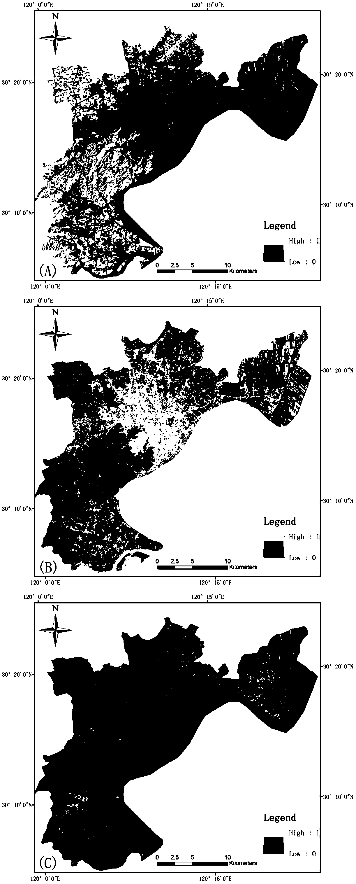
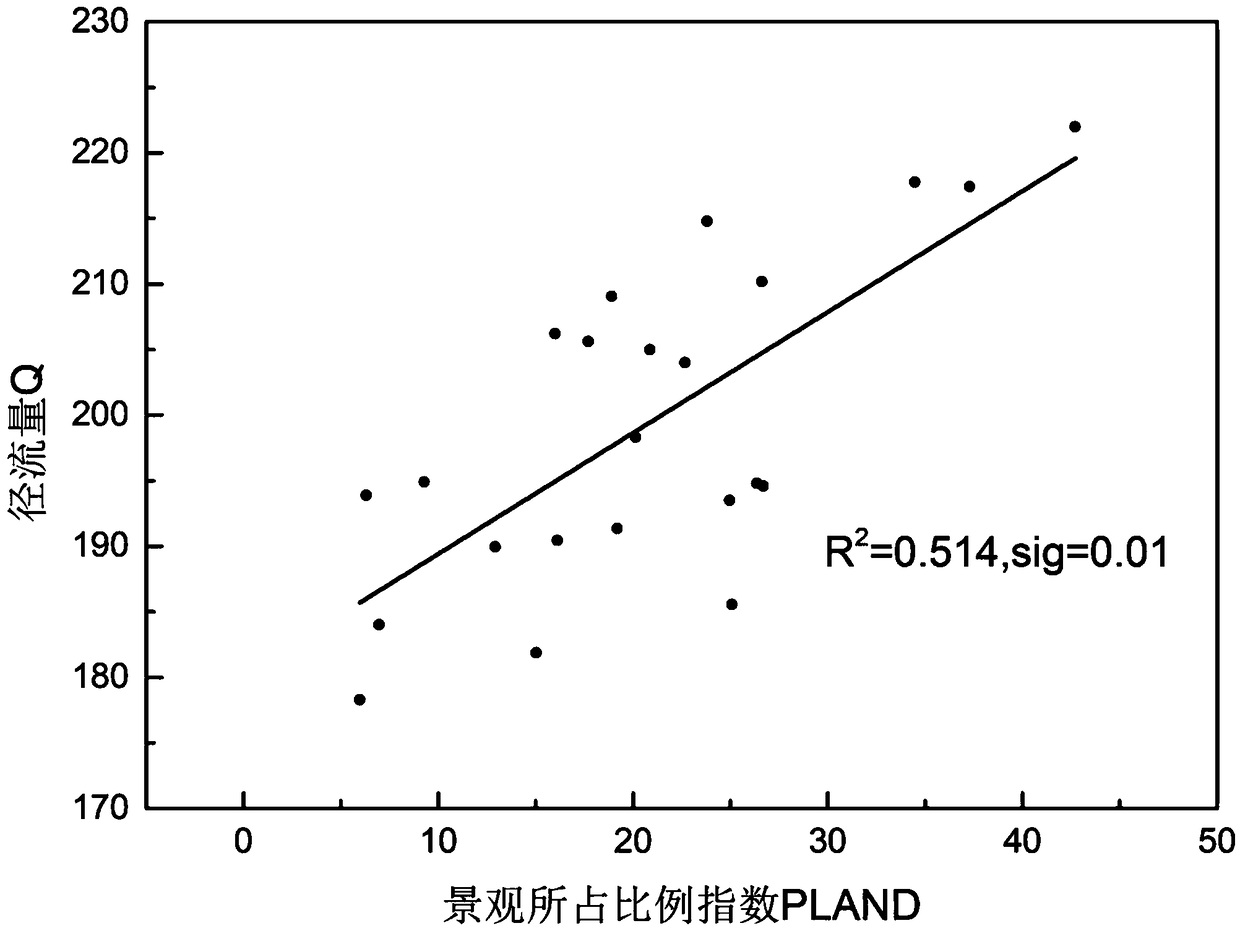
[0025] The "linear spectral decomposition and BCI index combination method" involved in the present invention is an important technical innovation for extracting urban impermeable surface, vegetation and soil coverage. Among them, the impermeable surface, vegetation and soil coverage extracted based on the combination of linear spectral decomposition and BCI index provide accurate input for the calculation of surface runoff.

[0026] (1) Extraction of impervious surface, vegetation and soil information based on linear spectral decomposition and BCI index combination

[0027] Before the traditional linear spectral decomposition, the remote sensing image is preprocessed: one is radiometric calibration; the other is water body mask; before calculating the BCI index, the tasseled cap ...


PUM


Abstract

During surface runoff simulation with remote sensing information, traditional LSMA (linear spectral mixture analysis for extraction can result in increased errors of impervious surface, vegetation andsoil and further affect surface runoff simulation precision. For solving the problem, the invention discloses a method for extracting imperious surface, vegetation and soil coverage through a BCI (biophysical composition index)-based linear spectral mixture analysis method and simulating surface runoff through a Soil Conservation Service Curve Number Method model. The method comprises the following steps of 1) extracting urban impervious surface, vegetation and soil coverage on the basis of a traditional LSMA method, computing BCI and correcting results; 2) taking the impervious surface, vegetation and soil coverage as the input of the SCS-CN (Soil Conservation Serve Curve Number) model to acquire simulated surface runoff; 3) computing and analyzing the landscape pattern index of the impervious surface to acquire the association between the landscape pattern index of the impervious surface of the simulated surface runoff and further detecting and predicting the surface runoff throughthe impervious surface.

Description

technical field [0001] The present invention designs an urban surface runoff detection method based on urban impermeable surface and DEM, which can better simulate urban surface runoff, realize monitoring and prediction of urban surface runoff, and provide good input and input for "sponge city" planning. support. Background technique [0002] In recent years, with the acceleration of urbanization, land use types have changed, and impervious surfaces have increased significantly, which has increased the risk of rainstorm and waterlogging in urban areas (Brabec, 2002). In order to solve problems such as water shortages and flood disasters, my country has put forward the theory of "sponge city", the core of which is to make it easier for rainwater to infiltrate, thereby reducing rainfall runoff (Kongjian Yu, 2015). How the expansion of the impermeable surface will affect the precipitation runoff is a practical problem to be solved urgently in the construction of "sponge city",...

Claims


Application Information

Patent Timeline
Patent Type & Authority Applications(China)
IPC IPC(8): G01N21/17
CPCG01N21/17G01N2021/1793
Inventor 孟庆岩要志鑫李家国王桥孙震辉
Owner INST OF REMOTE SENSING & DIGITAL EARTH CHINESE ACADEMY OF SCI
Why Eureka
Try Eureka