Satellite-borne AIS (Automatic Identification System) real-time information guidance based on-satellite independent imaging method

A technology of real-time information and imaging methods, applied in the directions of radio wave reflection/re-radiation, using re-radiation, measuring devices, etc., can solve problems such as long time intervals and difficult targets of ships on the sea surface, so as to improve accuracy and improve The effect of SAR imaging recognition confirmation efficiency and timeliness

Active Publication Date: 2019-03-22
BEIJING INST OF SPACECRAFT SYST ENG
View PDF8 Cites 25 Cited by
  • Summary
  • Abstract
  • Description
  • Claims
  • Application Information

AI Technical Summary

Problems solved by technology

According to the traditional space-borne SAR system, when the ship is imaged, the ship's position information is guided by the imaging results of other satellites or electronic reconnaissance information. When the s

Method used


Image

  • Satellite-borne AIS (Automatic Identification System) real-time information guidance based on-satellite independent imaging method
  • Satellite-borne AIS (Automatic Identification System) real-time information guidance based on-satellite independent imaging method
  • Satellite-borne AIS (Automatic Identification System) real-time information guidance based on-satellite independent imaging method

Examples


Embodiment Construction

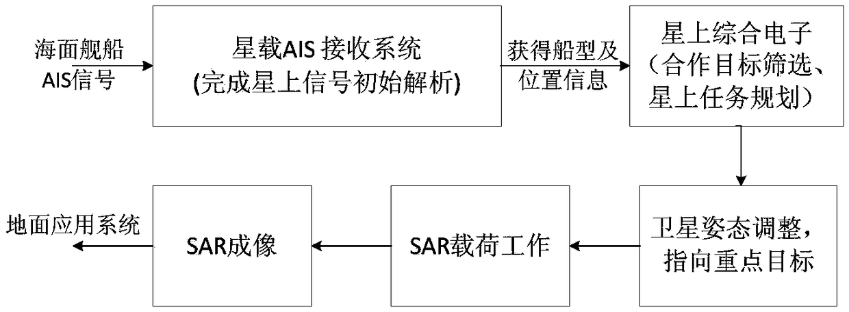
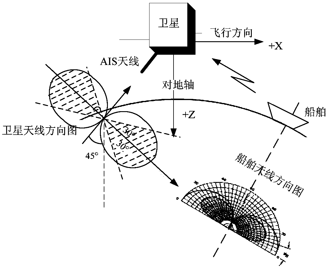
[0046] Attached below Figure 1-4 and specific embodiments clearly and completely describe the technical solutions in the embodiments of the present invention.

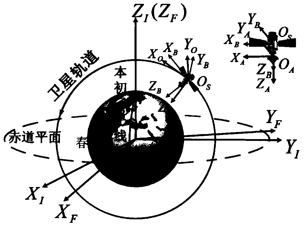
[0047] The coordinate systems used in this paper are: the earth-centered inertial coordinate system OE-XIYIZI, the earth-centered fixed coordinate system OE-XFYFZF, the satellite orbit coordinate system OS-XOYOZO, the satellite body coordinate system OS-XBYBZB and the antenna coordinate system OA-XAYAZA, such as image 3shown.

[0048] In this paper, the antenna is fixed directly below the satellite body, and the three axes of OA-XAYAZA are parallel to the corresponding coordinate axes of OS-XBYBZB. Since the distance between the antenna centroid OA and the satellite centroid OS is very short, the satellite centroid is used instead of the antenna phase center, and the satellite body coordinate system replaces the antenna coordinate system. The error of the beam projected on the ground is usually at the meter level. F...


PUM


Abstract

The invention discloses a satellite-borne AIS (Automatic Identification System) real-time information guidance based on-satellite independent imaging method, which comprises the following steps of (1), capturing and confirming a ship target needing to be observed; (2), determining satellite observation moment and observation area; (3), calculating an observation attitude of a satellite to a vessel; and (4), adjusting the attitude of the satellite, and determining that an SAR (Synthetic Aperture Radar) load can be used for carrying out imaging work. According to the method, the matching screening is carried out on an interesting target in real time by utilizing satellite-borne AIS information; an area to which the target is located is determined; the real-time resolving of data of a time, the attitude and an imaging parameter and the like needed by the imaging of an SAR load is realized; a satellite attitude adjustment instruction and an SAR load startup imaging instruction are automatically generated; and imaging tasks of a selected area and a selected target are completed. Through the comprehensive utilization of AIS information and SAR imaging information, the identification andconfirmation efficiency of a seaborne ship target is improved; the imaging accurate rate of the ship target is improved; and the observation efficiency of a system is improved.

Description

technical field [0001] The invention relates to an on-board autonomous imaging method guided by real-time information of the on-board AIS, calculates the imaging area and imaging target based on the real-time analysis information of the on-board AIS system, autonomously controls the SAR imaging function, and generates satellite attitude adjustment commands and SAR loads in real time Start the imaging command to complete the imaging task of the selected area and the selected target. The design can be applied in the fields of marine situational awareness, sea surface emergency search and rescue, etc. Background technique [0002] The imaging of traditional SAR satellites is designed for a specific scene or a fixed target (building). The imaging instructions are pre-designed on the ground or given instructions on the ground. Since the positions of ships on the sea surface are uncertain in advance, especially many The randomness of the SAR imaging task is relatively large for t...

Claims


Application Information

Patent Timeline
IPC IPC(8): G01S13/90
Inventor 麻丽香张玥张庆君朱宇刘亚东刘书豪何德华梁健
Owner BEIJING INST OF SPACECRAFT SYST ENG
Why Eureka
Try Eureka