A route planning method for multi-rotor UAV surveying and mapping under complex polygon survey area

A polygonal and surveying area technology, which is used in target search, low-altitude surveying and mapping UAV route planning, agricultural plant protection, and terrain exploration to achieve the effect of small redundant coverage area and short total route length.

Active Publication Date: 2020-11-10
BEIJING INSTITUTE OF TECHNOLOGYGY
View PDF7 Cites 0 Cited by
  • Summary
  • Abstract
  • Description
  • Claims
  • Application Information

AI Technical Summary

Problems solved by technology

However, the technical difficulty lies in the need to solve the multi-UAV communication problem to ensure the safety of UAV navigation and reduce the repeated coverage of multiple UAVs.

Method used


Image

  • A route planning method for multi-rotor UAV surveying and mapping under complex polygon survey area
  • A route planning method for multi-rotor UAV surveying and mapping under complex polygon survey area
  • A route planning method for multi-rotor UAV surveying and mapping under complex polygon survey area

Examples


Embodiment Construction

[0021] In order to make the object, technical solution and advantages of the present invention clearer, the present invention will be further described in detail below with reference to the accompanying drawings and examples.

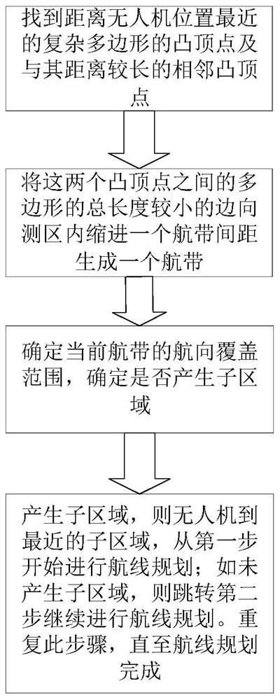
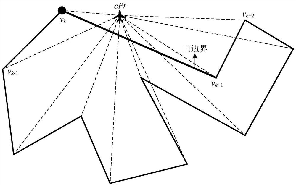
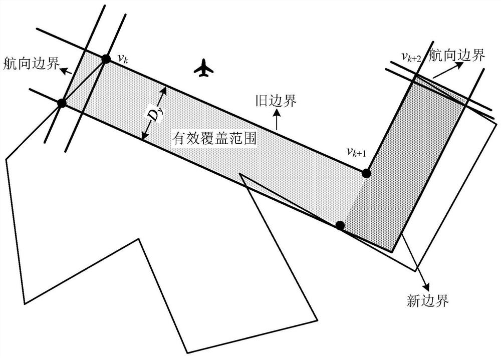
[0022] The present invention proposes a multi-rotor UAV surveying and mapping route planning method under complex polygonal surveying areas. Compared with the above-mentioned traditional methods, this scheme has smaller redundant coverage and fewer turns. The implementation method is mainly divided into two parts: the planning of a single flight path and the update of the remaining uncovered measurement areas: firstly, the planning of a single flight path is carried out according to the position of the UAV and the measurement area to be covered, and the longest flight path in the current state is obtained. Then consider the effective coverage area of ​​the track, update the remaining uncovered area and treat it as a new survey area or a group of new surv...


PUM


Abstract

The invention discloses a multi-rotor drone mapping air route planning method under complex polygon survey areas. The method is mainly divided into two parts, namely planning of a single flight zone and updating of remaining uncovered survey areas. According to the method, firstly, planning of the single flight zone is carried out according to the position of a drone and a to-be-covered survey area, a pair of longest navigation zone points of a navigation zone in the current state are obtained, then effective covered areas of the navigation zone are taken into account, the remaining uncoveredareas are updated and regarded as one new survey area or a group of new survey areas, the position of the drone is updated as the last navigation point of the navigation zone at the same time in orderto plane a next navigation zone until coverage of the whole survey areas is completed. By means of the method, an air route with a smaller redundant coverage rate and a lower turning frequency underthe complex polygon measuring areas can be planned.

Description

technical field [0001] The invention belongs to the technical field of route planning for low-altitude surveying and mapping UAVs, and specifically relates to a multi-rotor UAV surveying and mapping route planning method under complex polygon surveying areas, which can be widely used in terrain exploration, agricultural plant protection, target search and other fields. Background technique [0002] The surveying and mapping task of the rotor UAV includes selecting the survey area on the map, planning the flight route and exposure point according to the shape of the survey area and the image parameter requirements, and the ground station monitors the drone to perform the flight aerial photography task, using control points and features Point splicing images to obtain large-scale remote sensing maps. The high quality of tasks is reflected in the length of execution time, the amount of energy consumption, and the level of mapping accuracy. Therefore, the planning of the survey...

Claims


Application Information

Patent Timeline
Patent Type & Authority Patents(China)
IPC IPC(8): G05D1/10G01C11/00G01C21/20
CPCG01C11/00G01C21/20G05D1/101
Inventor 白永强周超陈杰鲁嘉坤王守奇甘明刚邓方蔡涛
Owner BEIJING INSTITUTE OF TECHNOLOGYGY
Why Eureka
Try Eureka