A three-bandwidth lane tight combination positioning method based on bds and gps fusion

A wide-lane combination and positioning method technology, applied to satellite radio beacon positioning systems, instruments, measuring devices, etc., can solve the problems of low positioning accuracy and no connection between systems, so as to enhance stability and improve positioning accuracy and reliability, reducing the effect of parameters to be estimated

Active Publication Date: 2022-07-22
SOUTHEAST UNIV
View PDF0 Cites 0 Cited by
  • Summary
  • Abstract
  • Description
  • Claims
  • Application Information

AI Technical Summary

Problems solved by technology

Multi-GNSS fusion mainly uses two models: one is the loose combination model in which each system selects its own reference satellite, that is, the intra-system difference model, without establishing the connection between the systems, and the positioning accuracy is low in the occlusion environment; the other is Different systems select a compact combination model of common reference satellites, that is, the inter-system difference model

Method used


Image

  • A three-bandwidth lane tight combination positioning method based on bds and gps fusion
  • A three-bandwidth lane tight combination positioning method based on bds and gps fusion
  • A three-bandwidth lane tight combination positioning method based on bds and gps fusion

Examples


Embodiment Construction

[0071] In order to make the objectives, technical solutions and advantages of the present invention clearer, the present invention will be described in detail below with reference to the accompanying drawings and specific embodiments.

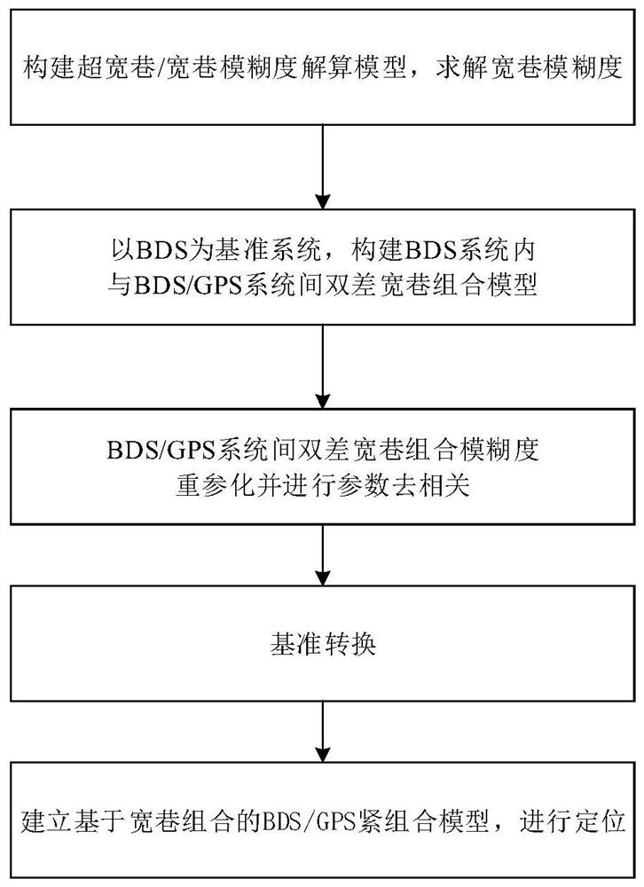
[0072] figure 1 It is a flow chart of the method, and the present invention provides a three-bandwidth lane tight combined positioning method fused by BDS and GPS, comprising the following steps:

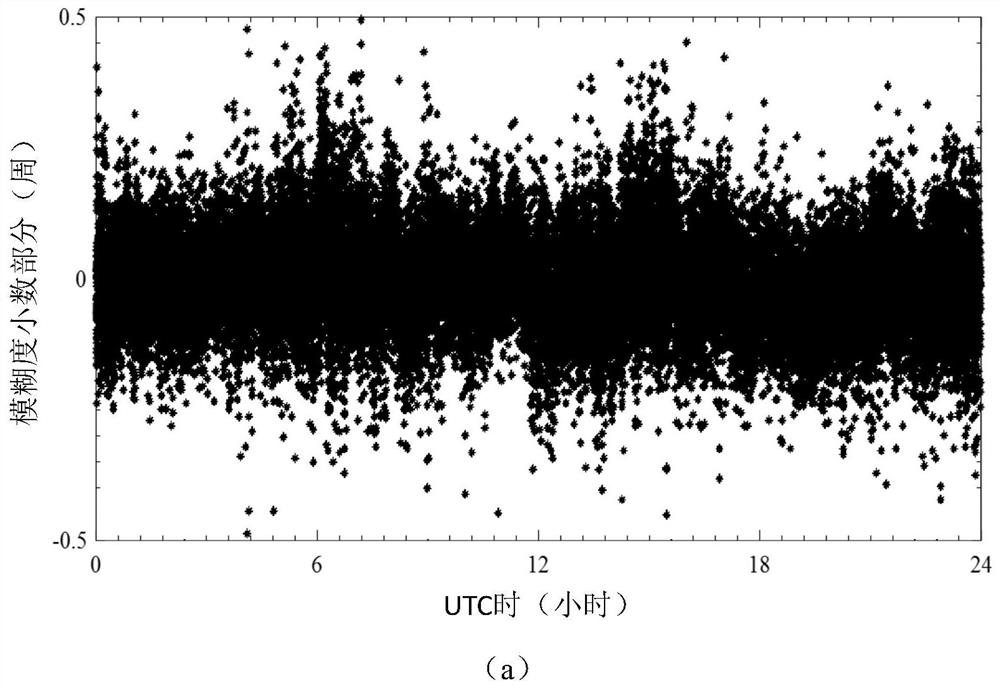
[0073] Step 1, using the tri-frequency data to fix the ambiguity of the ultra-wide lane combination (0, -1, 1), thereby assisting the solution of the ambiguity of the wide lane combination (1, -1, 0);

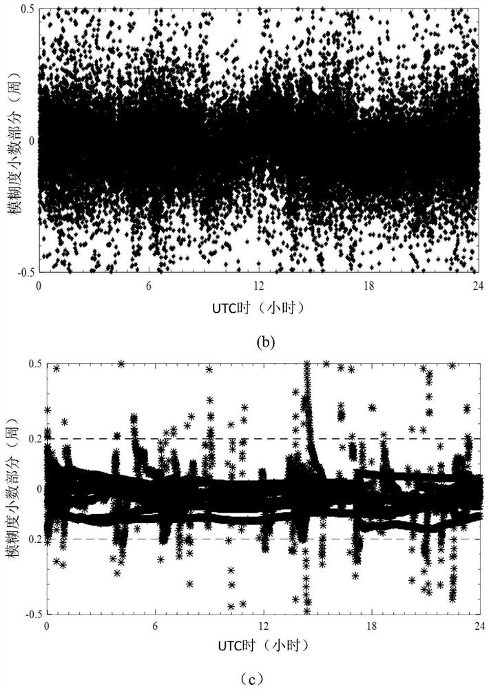
[0074] Step 2, with the BDS as the reference system, construct the double-difference wide-lane combination model in the BDS system and the double-difference wide-lane combination model between the BDS / GPS systems;

[0075] Step 3, reparameterize the ambiguity of the double-difference wide-lane combination between BDS / GPS systems and perform parameter...


PUM


Abstract

The invention discloses a three-frequency wide-lane tight combination positioning method fused by BDS and GPS. First, the ambiguity of the ultra-wide-lane combination (0, -1, 1) is fixed by using three-frequency data, thereby assisting the wide-lane combination ( 1, ‑1, 0) ambiguity solution; on this basis, with BDS as the reference system, the ambiguity of the double-difference wide-lane combination between BDS / GPS systems is reparameterized and the parameters are de-correlated, and the real-time estimation is based on the The carrier differential intersystem bias (DISB) of the lane combination, and the DISB is converted when the reference satellite changes to achieve the continuous estimability of the DISB, and its time-varying characteristics are statistically analyzed; BDS and GPS tight combination positioning model for wide-lane combination. The results show that the ultra-wide lane / wide lane ambiguity can be quickly and reliably fixed under the medium baseline, and the tight combination model between systems can significantly improve the positioning accuracy, especially in the occlusion environment with a small number of visible satellites.

Description

technical field [0001] The invention relates to the technical field of GNSS (Global Navigation Satellite System) positioning and navigation, in particular to a three-bandwidth lane-tight combined positioning method integrating BDS and GPS. Background technique [0002] RTK technology is one of the most widely used GNSS precision positioning technologies, and enables users to obtain high-precision positioning results in real time. Fast and reliable fixation of ambiguity is critical for obtaining real-time high-precision localization results. At present, in RTK positioning, the basic ambiguity of L1 or L2 is generally solved for positioning solution, but it is affected by factors such as distance between base stations, atmospheric delay error, observation environment, etc., the success of ambiguity solution in a short period of time The rate of ambiguity is low, and its initialization time is very long. In the case of poor observation environment, the ambiguity cannot be fixe...

Claims


Application Information

Patent Timeline
Patent Type & Authority Patents(China)
IPC IPC(8): G01S19/46G01S19/44
CPCG01S19/44G01S19/46
Inventor 潘树国闻贺高旺赵庆刘力玮赵越王云凤盛超
Owner SOUTHEAST UNIV
Why Eureka
Try Eureka