Geographic information identification method and device based on deep learning
A deep learning and geographic information technology, applied in the field of geographic information recognition, can solve the problem of low accuracy of geographic information recognition, and achieve the effect of solving the problem of low recognition accuracy, improving efficiency and accuracy, and accurate geographic information recognition.
- Summary
- Abstract
- Description
- Claims
- Application Information
AI Technical Summary
Problems solved by technology
Method used
Image
Examples
Embodiment 1
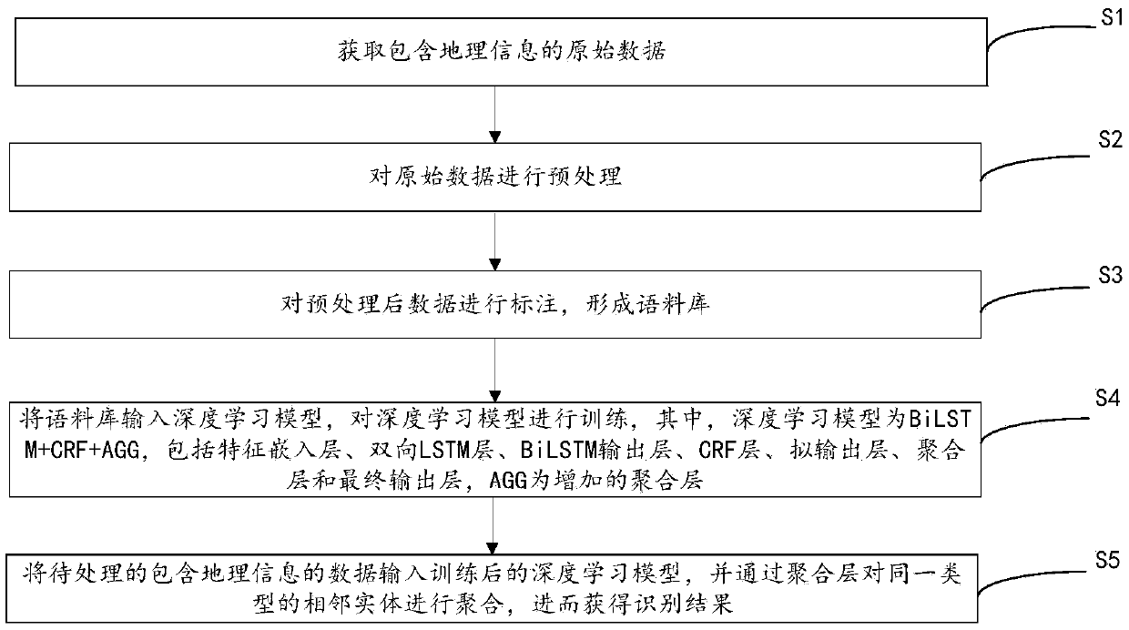
[0051] This embodiment provides a method for identifying geographic information based on deep learning, please refer to figure 1 , the method includes:
[0052] First, step S1 is executed: obtaining raw data including geographic information.
[0053] Specifically, raw data can be obtained through existing tools or from existing databases. For example, get it from the network through a crawler.
[0054] Then execute step S2: preprocessing the original data.
[0055] Specifically, due to duplication or errors in the acquired raw data, in order to ensure the quality of the annotation, these data need to be preprocessed, such as data screening, cleaning, etc.
[0056] Next, step S3 is executed: labeling the preprocessed data to form a corpus.
[0057] Specifically, the way of labeling can be manual labeling, automatic labeling or a combination of both. Among them, the automatic labeling method can adopt an active learning strategy, that is, according to the preset selection r...
Embodiment 2
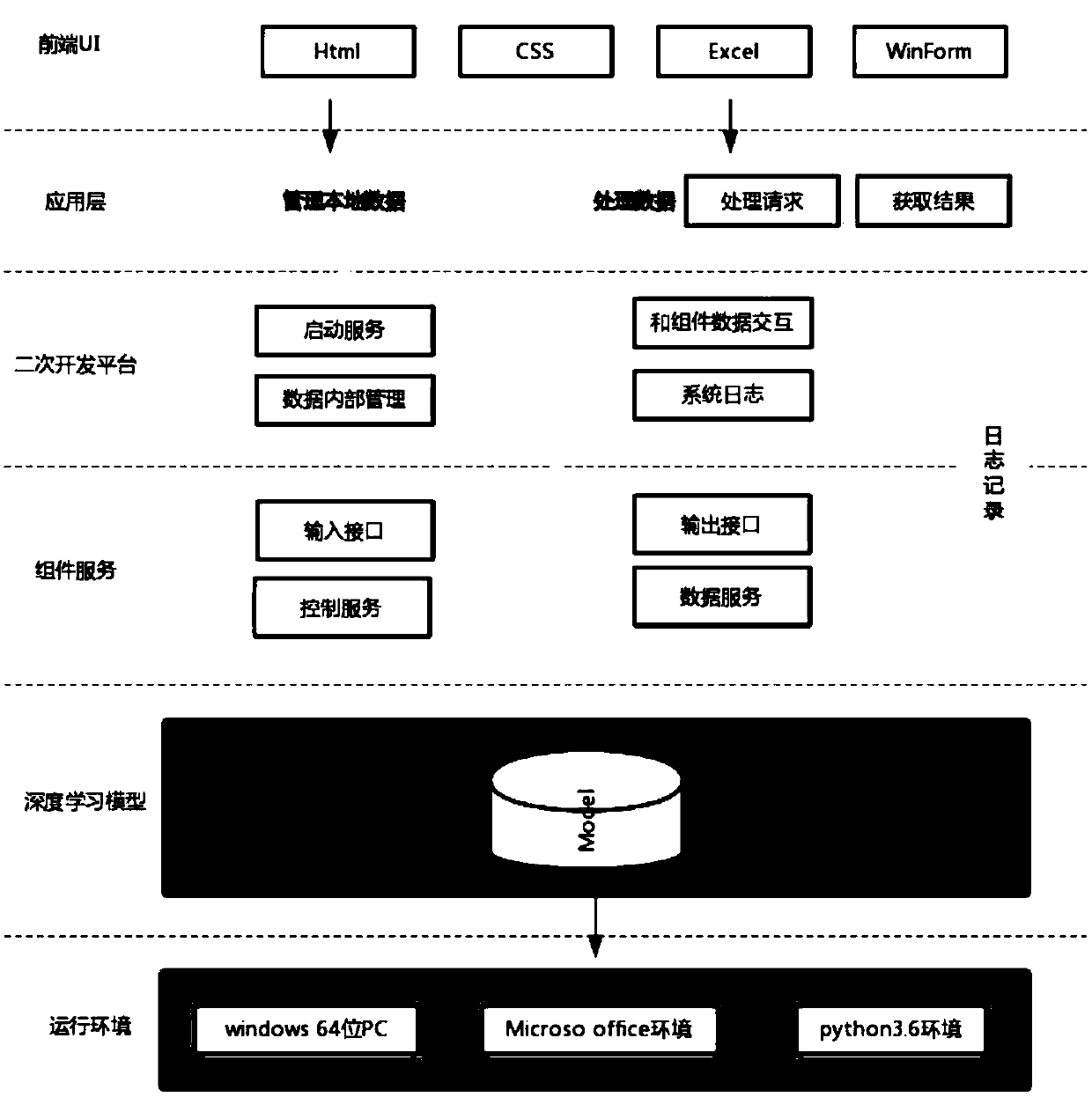
[0156] This embodiment provides a recognition device based on deep learning geographic information, please refer to Figure 9 , the device consists of:
[0157] An acquisition module 601, configured to acquire raw data containing geographic information;
[0158] A preprocessing module 602, configured to preprocess the raw data;
[0159] Annotation module 603, configured to annotate the preprocessed data to form a corpus;
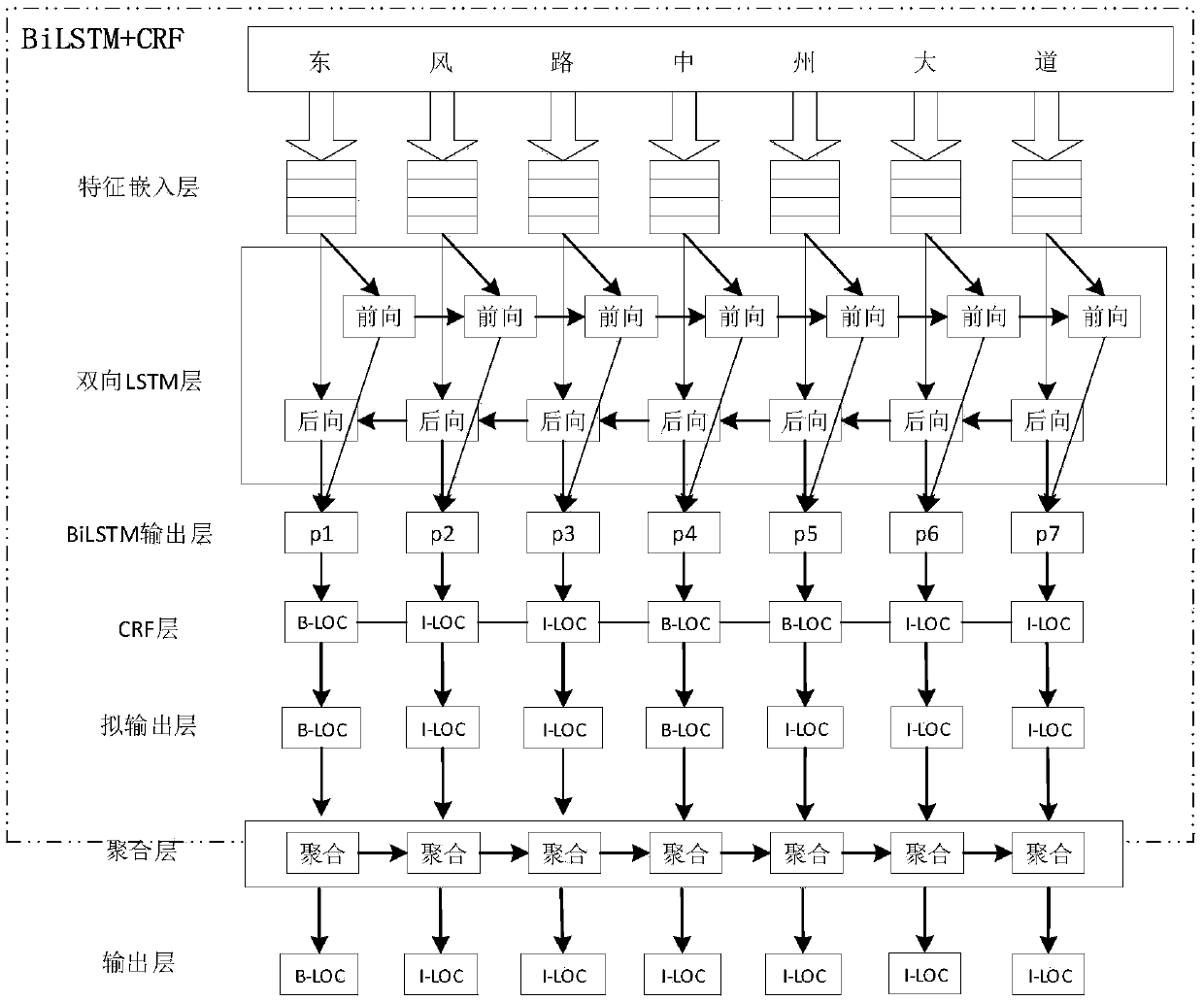
[0160] The training module 604 is used to input the corpus into the deep learning model to train the deep learning model, wherein the deep learning model is BiLSTM+CRF+AGG, including a feature embedding layer, a bidirectional LSTM layer, a BiLSTM output layer, a CRF layer, and a quasi-output layer Layer, aggregation layer and final output layer, AGG is the added aggregation layer;
[0161] The recognition module 605 is configured to input the data containing geographic information to be processed into the trained deep learning model, and aggregate adjacen...
PUM
 Abstract
Description
Claims
Application Information
 - R&D
- Intellectual Property
- Life Sciences
- Materials
- Tech Scout
- Unparalleled Data Quality
- Higher Quality Content
- 60% Fewer Hallucinations
Browse by: Latest US Patents, China's latest patents, Technical Efficacy Thesaurus, Application Domain, Technology Topic, Popular Technical Reports.
© 2025 PatSnap. All rights reserved.Legal|Privacy policy|Modern Slavery Act Transparency Statement|Sitemap|About US| Contact US: help@patsnap.com


