Surveying and mapping method and device, computer equipment and storage medium

A computer program and calculated technology, applied in the direction of electromagnetic measuring device, electric/magnetic area measurement, etc., can solve problems such as poor user experience, time-consuming and labor-intensive, unsuitable for people's daily use, etc.

Active Publication Date: 2019-04-16
SHENZHEN WATER WORLD INFORMATION CO LTD
View PDF8 Cites 3 Cited by
  • Summary
  • Abstract
  • Description
  • Claims
  • Application Information

AI Technical Summary

Problems solved by technology

[0002] At present, most of the land area is measured by professional measuring instruments and manual measurement; using a measuring instrument to measure the area requires professionals to use it correctly, and at the same time, the measuring instrument is expensive and not suitable for people's daily use; and manual measurement requires manual throughput. Use a ruler to measure

Method used


Image

  • Surveying and mapping method and device, computer equipment and storage medium
  • Surveying and mapping method and device, computer equipment and storage medium
  • Surveying and mapping method and device, computer equipment and storage medium

Examples


Embodiment Construction

[0050] It should be understood that the specific embodiments described here are only used to explain the present invention, not to limit the present invention.

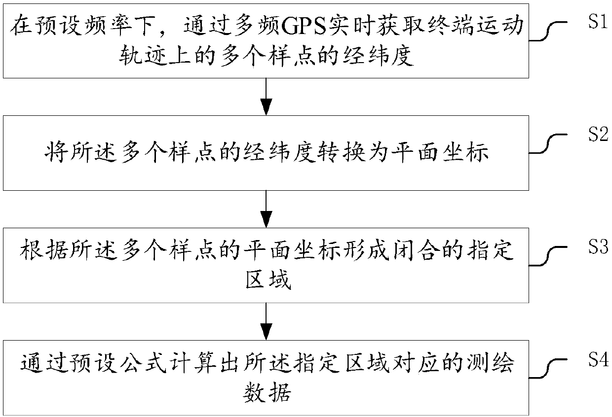
[0051] refer to figure 1 , an embodiment of the surveying and mapping method of the present invention, comprising:

[0052] S1, at a preset frequency, obtain the latitude and longitude of multiple sample points on the terminal movement track in real time through multi-frequency GPS;

[0053] S2, converting the latitude and longitude of the plurality of sample points into plane coordinates;

[0054] S3, forming a closed designated area according to the plane coordinates of the plurality of sample points;

[0055] S4. Calculate the surveying and mapping data corresponding to the specified area through a preset formula.

[0056] This method can be applied to terminals, but is not limited to the above-mentioned terminals. The above-mentioned terminals include any terminal equipment such as mobile phones, tablet compute...


PUM


Abstract

The invention discloses a surveying and mapping method and device, computer equipment and a storage medium. The method comprises the following steps that: under preset frequency, through a multi-frequency GPS (Global Positioning System), obtaining the longitudes and latitudes of a plurality of sample points on a terminal movement locus; converting the longitudes and latitudes of the plurality of sample points into plane coordinates; according to the plane coordinates of the plurality of sample points, forming a closed appointed zone; and through a preset formula, calculating surveying and mapping data corresponding to the appointed zone. By use of the method, the built-in multi-frequency GPS of an intelligent terminal is used for realizing sub-meter level positioning, sample points with ahighest amount in the appointed zone are collected, the plurality of collected sample points are fit into a polygonal appointed zone, and therefore, the area and the perimeter of the polygonal appointed zone are calculated.

Description

technical field [0001] The invention relates to the technical field of digital measurement, in particular to a surveying and mapping method, device, computer equipment and storage medium. Background technique [0002] At present, most of the land area is measured by professional measuring instruments and manual measurement; using a measuring instrument to measure the area requires professionals to use it correctly, and at the same time, the measuring instrument is expensive and not suitable for people's daily use; and manual measurement requires manual throughput. Using a ruler to measure and manually calculate the area, manual measurement is time-consuming and laborious, and the accuracy is low. [0003] Therefore, in the prior art, the built-in GPS of the smart phone is used to measure the area, and the positioning error is more than 5 meters, which cannot be used for high-precision area measurement, so the accuracy is low and the user experience is not good. Contents of...

Claims


Application Information

Patent Timeline
IPC IPC(8): G01B7/32
CPCG01B7/32
Inventor 郑勇夏志祥黄夏清王辉
Owner SHENZHEN WATER WORLD INFORMATION CO LTD
Why Eureka
Try Eureka