
A self-organization method of geospatial data based on information entropy

A geospatial data and information entropy technology, applied in the field of geospatial data self-organization based on information entropy, can solve problems such as complex customer groups, loss of search efficiency and accuracy, and achieve the effect of improving accuracy and efficiency

Active Publication Date: 2021-08-10
BEIJING AEROSPACE TITAN TECH CO LTD
View PDF4 Cites 0 Cited by
  • Summary
  • Abstract
  • Description
  • Claims
  • Application Information

AI Technical Summary

Problems solved by technology

[0012] The purpose of the present invention is to solve the problem in the prior art that due to the wide application of geospatial data in the industry and the complexity of customer groups, the efficiency and accuracy of search will be lost in the face of changing search purposes in the same data organization mode

Method used


Image

  • A self-organization method of geospatial data based on information entropy
  • A self-organization method of geospatial data based on information entropy
  • A self-organization method of geospatial data based on information entropy

Examples


Embodiment

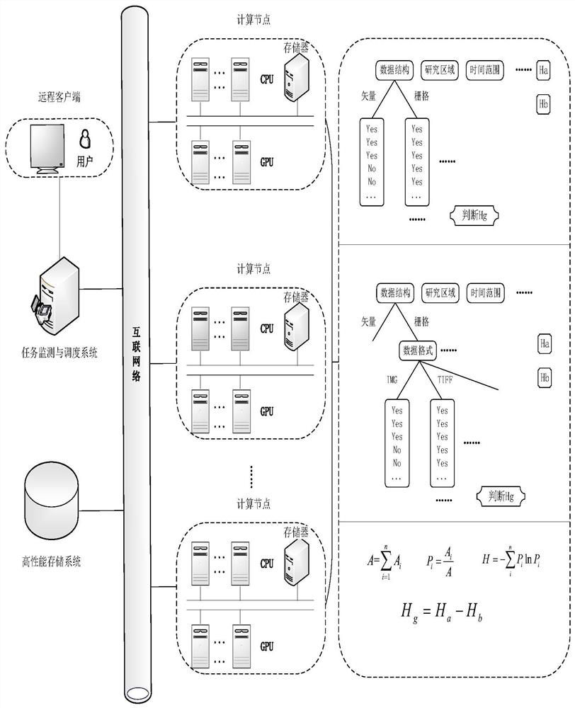
[0064] S1. The user enters search conditions on the client terminal. Due to the complexity of geospatial data, multiple conditions are set for the user to choose, including data format, research area, time range, cloud cover and scale / spatial resolution, etc.;

[0065] S2. The client sends the search condition to the blade server in the form of an instruction, and the blade server takes out the geospatial data from the disk array for model calculation;

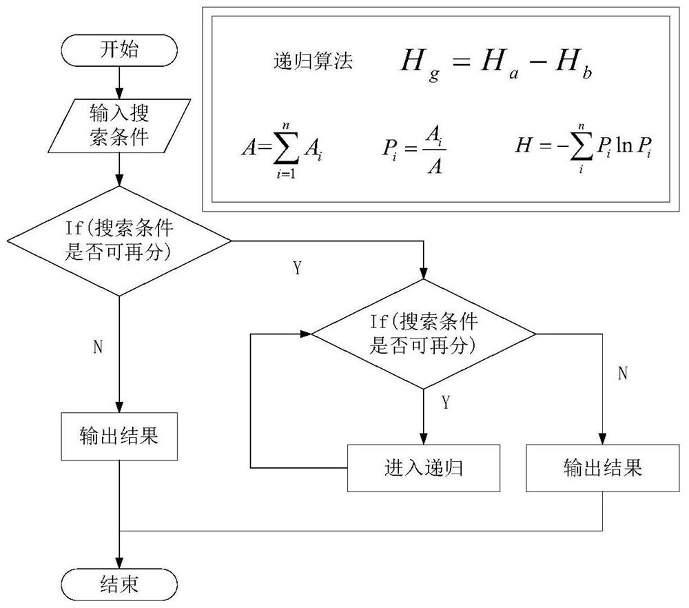
[0066] S3. First construct the search condition information entropy H according to the Shannon entropy formula, and the number of types of the search conditions is n: the first type of search condition A 1 , ..., the i-th search condition A i ...the nth category of search criteria A n ;

[0067] Such as figure 2 As shown, take each type of search condition as the parent node; calculate the information entropy H of the parent node a :

[0068]

[0069]

[0070]

[0071] Where: P i It is the percentage of various...


PUM


Abstract

A self-organizing method for geospatial data based on information entropy of the present invention is used to realize self-organized storage of geospatial data on a spatio-temporal information cloud service platform; the method includes: step 1) receiving search conditions, and reading according to the search conditions Geospatial data; step 2) constructing an optimal decision tree based on information entropy according to the search conditions; step 3) classifying the geospatial data according to the optimal decision tree model to realize self-organizing storage and management. Improve the efficiency of users searching for geospatial data; improve the accuracy of navigation and positioning; meet the wide range of industry applications, complex, personalized and diversified search needs of customer groups; effectively utilize the distributed processing capabilities of multi-machine clusters, adopt High-speed storage system network and related services to realize TB-level massive geospatial data storage, management and access.

Description

technical field [0001] The present invention relates to the technical field of big data mining, in particular to a self-organizing method for geospatial data based on information entropy. Background technique [0002] Information entropy was proposed by American data scientist Shannon based on information theory in 1948, and it is used to reflect the lack of people's internal configuration information of the system or the measurement of the uncertainty of a random event. The formula for calculating the information entropy is as follows: [0003] n possible information X 1 ,X 2 ,...,X n , the probability of which is P 1 ,P 2 ,...,P n ,and function [0004] Where k is a proportional coefficient, and the information entropy is used to represent the average amount of information provided by each piece of information after the information source is output, or the average degree of uncertainty before the information source is output. That is, the greater the uncertai...

Claims


Application Information

Patent Timeline
Patent Type & Authority Patents(China)
IPC IPC(8): G06F16/29
Inventor 钱晓明许青云
Owner BEIJING AEROSPACE TITAN TECH CO LTD
Learn More