Urban design digitization and visualization interaction system

A technology of urban design and interactive system, applied in the direction of digital data processing, computing, special data processing applications, etc., can solve the problem of poor urban design effect, the inability to intuitively display urban design landscape, style, features, and reduce the efficiency of urban design and other issues to achieve the effect of increasing public interaction, increasing satisfaction, and improving results

Pending Publication Date: 2019-04-30
广州市天作建筑规划设计有限公司
View PDF3 Cites 9 Cited by
  • Summary
  • Abstract
  • Description
  • Claims
  • Application Information

AI Technical Summary

Problems solved by technology

At present, urban design only has two-dimensional results in text, and the design process lacks a platform for public interaction and participation. It is impossible t

Method used


Image

  • Urban design digitization and visualization interaction system

Examples


Embodiment Construction

[0024] The present invention will be described in further detail below in conjunction with the accompanying drawings.

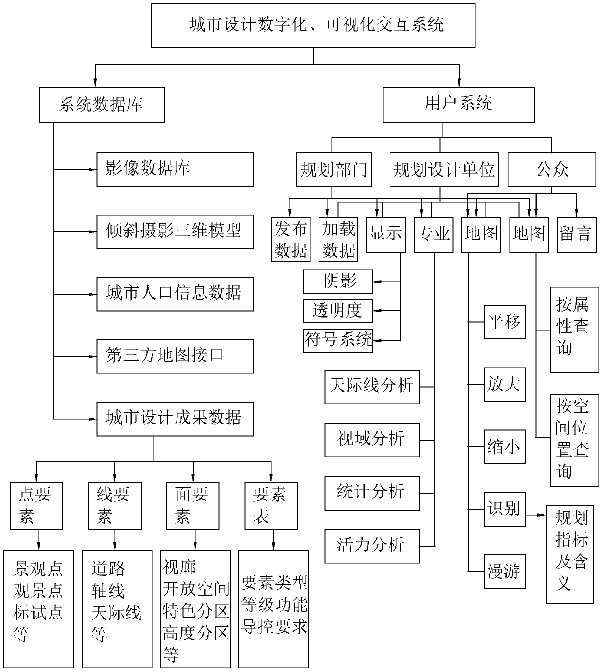
[0025] refer to figure 1 , a digital and visual interactive system for urban design disclosed by the present invention, including a system database and a user system.

[0026] The digital and visual interactive system of urban design is a platform developed through the secondary development of gis. The spatial database function, professional analysis function and display adjustment function in this platform convert the urban planning and design results in text or two-dimensional view into three-dimensional urban design Model and publicize the 3D urban design model approved by the government in the user system, and obtain the public's suggestions and opinions to modify and adjust the 3D urban design model to obtain the final urban design plan.

[0027] The system database refers to the database that stores the basic data of urban planning. The database can b...


PUM


Abstract

The invention relates to the technical field of urban planning, in particular to an urban design digitization and visualization interaction system which comprises a system database and a user system.The system database comprises a basic spatial geographic database, an oblique photography three-dimensional model database and an urban design spatial database; the space basic sand table module comprises a basic image base map and oblique photography three-dimensional model data retrieved from an oblique photography three-dimensional model database; wherein the space basic sand table module is used for calling a basic image base map from the basic space geographic database and calling corresponding oblique photography three-dimensional model data from the oblique photography three-dimensionalmodel data set library, and the space basic sand table module is used for constructing an urban design three-dimensional model in the urban design space database. The method has the effect of reflecting the urban planning result by constructing the urban design three-dimensional model.

Description

technical field [0001] The invention relates to the technical field of urban planning, in particular to a digitized and visualized interactive system for urban design. Background technique [0002] At present, in order to improve the level of urban design and carry out urban design work, through urban design, the urban architectural layout is coordinated from the overall plane and three-dimensional space, the urban landscape style is coordinated, and the urban regional characteristics, national characteristics and the style of the times are reflected. At present, urban design only has two-dimensional results in text, and the design process lacks a platform for public interaction and participation. It is impossible to intuitively display the landscape, style, and characteristics of urban design, which makes the effect of urban design poor and reduces the efficiency of urban design. Contents of the invention [0003] The purpose of the present invention is to provide a digit...

Claims


Application Information

Patent Timeline
IPC IPC(8): G06F17/50
CPCG06F30/13
Inventor 郑书剑郑燕
Owner 广州市天作建筑规划设计有限公司
Why Eureka
Try Eureka